Kulpi, Queensland

Last updated

Map all coordinates using: OpenStreetMap  
Download coordinates as: KML

Kulpi
Queensland
Australia Queensland location map.svg
Red pog.svg
Kulpi
Coordinates 27°11′15″S151°42′00″E / 27.1875°S 151.7°E / -27.1875; 151.7 (Kulpi (town centre)) Coordinates: 27°11′15″S151°42′00″E / 27.1875°S 151.7°E / -27.1875; 151.7 (Kulpi (town centre))
Population77 (2016 census) [1]
 • Density3.277/km2 (8.49/sq mi)
Postcode(s) 4352
Area23.5 km2 (9.1 sq mi)
Time zone AEST (UTC+10:00)
Location
LGA(s) Toowoomba Region
State electorate(s) Condamine
Federal division(s) Groom
Suburbs around Kulpi:
Quinalow Peranga Evergreen
Quinalow Kulpi Mount Darry
Brymaroo Rosalie Plains Mount Darry

Kulpi is a rural town and locality in the Toowoomba Region, Queensland, Australia. [2] [3] In the 2016 census, the locality of Kulpi had a population of 77 people. [1]

Contents

Geography

Kulpi is on the Darling Downs, 194 kilometres (121 mi) north west of the state capital, Brisbane. [4]

The Oakey–Cooyar Road runs through from south to north. [5]

History

The site of the town of Kulpi was part of a selection made by Fred Beckmann from the Rosalie Plains pastoral run. Beckman built two establishments, the Pioneer Hotel and a store which formed the centre of the town. The settlement was originally known as Rosalie, however the name was soon changed to Kulpi, to avoid confusion with the Rosalie Plains Homestead, which was a small town in itself. [6]

The town takes its name from its railway station name assigned to 9 January 1913 by the Queensland Railways Department. It is an reportedly an Aboriginal word meaning box tree [2] [7] or charred logs. [6]

Kulpi State School opened on 9 August 1915. [8]

In the 2016 census, the locality of Kulpi had a population of 77 people. [1]

Facilities

Library services in Kulpi are provided by the Toowoomba Regional Council's mobile library service. The van visits Kulpi State School on the 1st and 3rd Tuesday of each month. [9]

Education

Kulpi State School is a government primary (Prep-6) school for boys and girls at 9 Beckman Street ( 27°11′11″S151°42′00″E / 27.1865°S 151.6999°E / -27.1865; 151.6999 (Kulpi State School) ). [10] [11] In 2017, the school had an enrolment of 16 students with 3 teachers (1 full-time equivalent) and 6 non-teaching staff (2 full-time equivalent). [12] In 2018, the school had an enrolment of 22 students with 3 teachers (1 full-time equivalent) and 7 non-teaching staff (2 full-time equivalent). [13]

There are no secondary schools in Kulpi. The nearest government secondary schools are Quinalow State School (to Year 10) in neighbouring Quinalow to the north-west and Oakey State High School (to Year 12) in Oakey to the south. [14]

Related Research Articles

Oakey, Queensland Town in Queensland, Australia

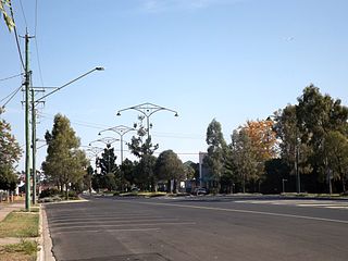
Oakey is a rural town and locality in the Toowoomba Region, Queensland, Australia. In the 2016 census, the locality of Oakey had a population of 4,705 people.

Gowrie Junction is a rural locality in the Toowoomba Region, Queensland, Australia. It is north-west of Toowoomba. In the 2016 census, Gowrie Junction had a population of 2,120 people. The town of Gowrie is in the eastern part of the locality.

Peranga is a rural town and locality in the Toowoomba Region, Queensland, Australia. In the 2016 census the locality of Peranga had a population of 85 people.

Kingsthorpe, Queensland Town in Queensland, Australia

Kingsthorpe is a rural town and locality in the Toowoomba Region, Queensland, Australia. In the 2016 census, the locality of Kingsthorpe had a population of 1,867 people.

Acland, Queensland Town in Queensland, Australia

Acland is a rural town and locality in the Toowoomba Region, Queensland, Australia. In the 2016 census the locality of Acland had a population of 32 people.

Bowenville, Queensland Town in Queensland, Australia

Bowenville is a rural town and locality in the Toowoomba Region, Queensland, Australia. The town's economy rested on the rail industry and with the winding down of the railways the population declined. In the 2016 census, the locality of Bowenville had a population of 250 people.

Goombungee, Queensland Town in Queensland, Australia

Goombungee is a rural town and locality in the Toowoomba Region, Queensland, Australia. In the 2016 census the locality of Goombungee had a population of 1,026 people.

Quinalow Town in Queensland, Australia

Quinalow is a rural town and locality in the Toowoomba Region, Queensland, Australia. In the 2016 census the locality of Quinalow had a population of 173 people.

Wellcamp, Queensland Suburb of Toowoomba Region, Queensland, Australia

Wellcamp is a rural locality in the Toowoomba Region, Queensland, Australia. In the 2016 census, Wellcamp had a population of 295 people.

Harristown, Queensland Suburb of Toowoomba, Queensland, Australia

Harristown is a residential locality in Toowoomba in the Toowoomba Region, Queensland, Australia. In the 2016 census, Harristown had a population of 8,555 people.

Haden is a rural town and locality in the Toowoomba Region, Queensland, Australia. In the 2016 census, the locality of Haden had a population of 195 people.

Jondaryan, Queensland Town in Queensland, Australia

Jondaryan is a rural town and locality in the Toowoomba Region, Queensland, Australia. In the 2016 census, the locality of Jondaryan had a population of 385 people.

Biddeston, Queensland Town in Queensland, Australia

Biddeston is a rural town and locality in the Toowoomba Region, Queensland, Australia. In the 2016 census the locality of Biddeston had a population of 284 people.

East Greenmount, Queensland Suburb of Toowoomba Region, Queensland, Australia

East Greenmount is a rural town and locality in the Toowoomba Region, Queensland, Australia. In the 2016 census, the locality of East Greenmount had a population of 361 people.

Maclagan, Queensland Town in Queensland, Australia

Maclagan is a rural town and locality in the Toowoomba Region, Queensland, Australia. In the 2016 census the locality of Maclagan had a population of 195 people.

Evergreen is a rural town and locality in the Toowoomba Region, Queensland, Australia. In the 2016 census, the locality of Evergreen had a population of 45 people.

Nutgrove is a rural locality in the Toowoomba Region, Queensland, Australia. In the 2016 census Nutgrove had a population of 32 people.

Mount Darry is a rural locality in the Toowoomba Region, Queensland, Australia. In the 2016 census Mount Darry had a population of 35 people.

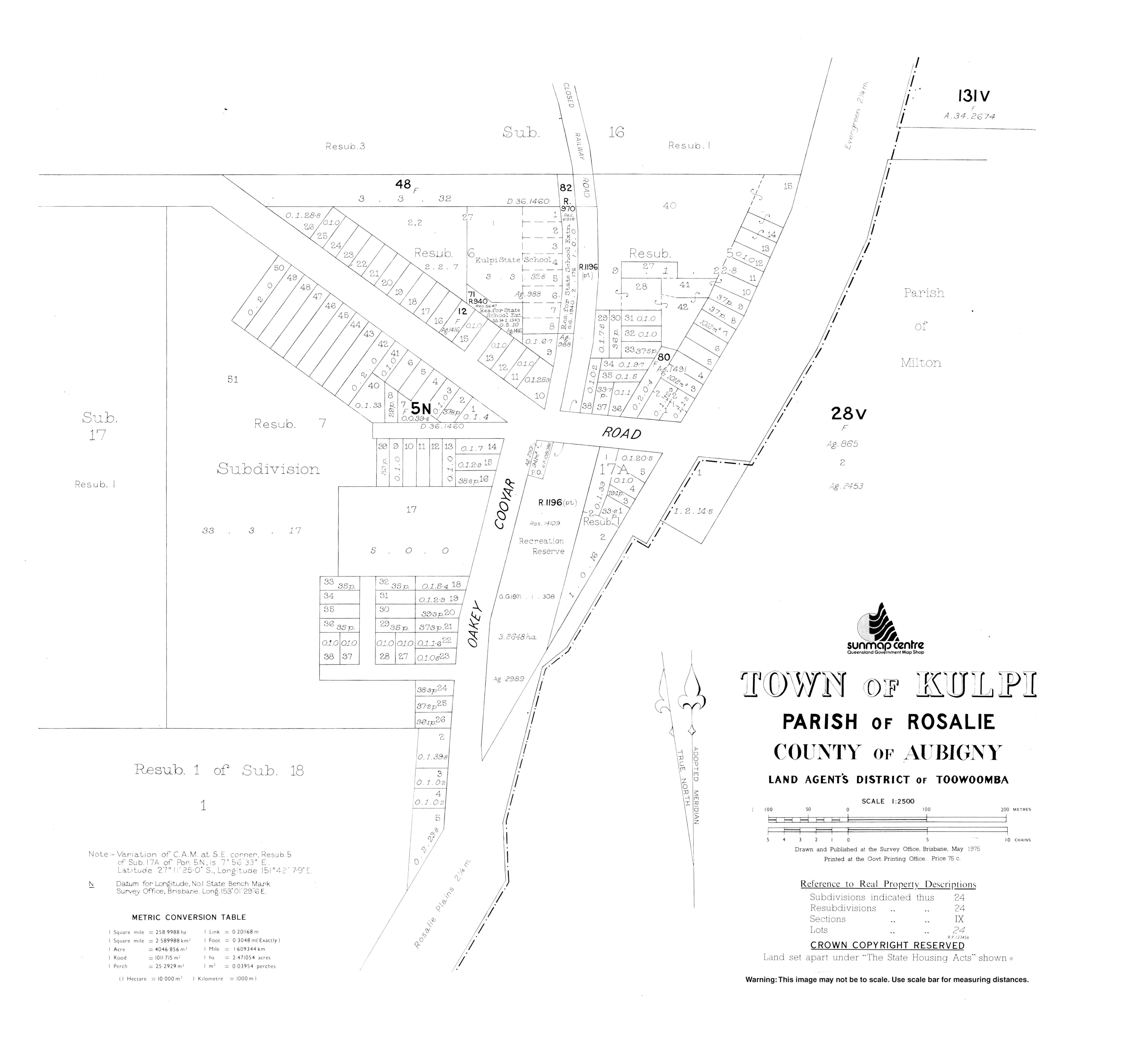
Oakey–Cooyar Road is a continuous 58.8 kilometres (36.5 mi) road route in the Darling Downs and Toowoomba regions of Queensland, Australia. The entire route is signed as State Route 68. It is a state-controlled part regional and part district road . It provides an alternate route between the Warrego Highway and the New England Highway, bypassing Toowoomba.

The roads that join the towns of Dalby, Toowoomba and Cooyar form a triangle that encloses some of the most fertile land on the Darling Downs in Queensland, Australia. These roads are the Warrego Highway, New England Highway and Dalby–Cooyar Road. Pechey–Maclagan Road forms a large part of a group of roads that bisect the triangle from east to west, and is also part of one of the groups of roads that bisect from south to north.

References

  1. 1 2 3 Australian Bureau of Statistics (27 June 2017). "Kulpi (SSC)". 2016 Census QuickStats. Retrieved 20 October 2018. OOjs UI icon edit-ltr-progressive.svg
  2. 1 2 "Kulpi – town in Toowoomba Region (entry 18583)". Queensland Place Names. Queensland Government . Retrieved 7 March 2022.
  3. "Kulpi – locality in Toowoomba Region (entry 49219)". Queensland Place Names. Queensland Government . Retrieved 7 March 2022.
  4. "Where is". Archived from the original on 24 October 2014. Retrieved 24 October 2014.
  5. Kulpi, Queensland (Map). OpenStreetMap. Archived from the original on 18 January 2022. Retrieved 18 January 2022.
  6. 1 2 Beal, Diana J. (Diana Joy); Phipps, Ross; Rosalie (Qld.). Council (1979). Rosalie Shire Council : The first one hundred years, 1879-1979. Rosalie Shire Council. Archived from the original on 4 March 2016. Retrieved 24 October 2014.
  7. "SKETCHER". The Queenslander . No. 2456. Queensland, Australia. 11 April 1914. p. 8. Archived from the original on 26 December 2020. Retrieved 28 November 2019 via National Library of Australia.
  8. Queensland Family History Society (2010), Queensland schools past and present (Version 1.01 ed.), Queensland Family History Society, ISBN   978-1-921171-26-0
  9. "Mobile library". Toowoomba Regional Council. Archived from the original on 24 October 2014. Retrieved 10 November 2014.
  10. "State and non-state school details". Queensland Government. 9 July 2018. Archived from the original on 21 November 2018. Retrieved 21 November 2018.
  11. "Kulpi State School". Archived from the original on 19 March 2020. Retrieved 21 November 2018.
  12. "ACARA School Profile 2017". Archived from the original on 22 November 2018. Retrieved 22 November 2018.
  13. "ACARA School Profile 2018". Australian Curriculum, Assessment and Reporting Authority. Archived from the original on 27 August 2020. Retrieved 28 January 2020.
  14. "Queensland Globe". State of Queensland . Retrieved 23 June 2022.

Further reading