Dunmore, Queensland

Last updated

Dunmore
Queensland
Australia Queensland location map.svg
Red pog.svg
Dunmore
Coordinates 27°40′00″S150°58′00″E / 27.6666°S 150.9666°E / -27.6666; 150.9666 (Dunmore (centre of locality))
Population39 (SAL 2021) [1]
Postcode(s) 4407
Area509.9 km2 (196.9 sq mi)
Time zone AEST (UTC+10:00)
Location
LGA(s) Toowoomba Region
State electorate(s) Southern Downs
Federal division(s) Maranoa
Suburbs around Dunmore:
Cattle Creek Halliford Cecil Plains
Cattle Creek Dunmore Kurrowah
Western Creek Western Creek Western Creek

Dunmore is a rural locality in the Toowoomba Region, Queensland, Australia. [2] In the 2021 census, Dunmore had a population of 39 people. [3]

Contents

Geography

About half of land area of the locality is protected within the Dunmore State Forest to the west, the Western Creek State Forest in the south-west and the Kumbarilla State Forest in the north-east. [4]

Apart from the protected areas, the land use is a mixture of grazing on native vegetation and crop growing with feedlots in the centre of the locality. [4]

History

The locality takes its name from the parish name, which in turn was named after the pastoral run held by Robert Logan in the 1840s. The run might have been named in honour of Presbyterian minister John Dunmore Lang. [2]

Demographics

In the 2016 census, Dunmore had a population of 26 people. [5]

In the 2021 census, Dunmore had a population of 39 people. [3]

Education

There are no schools in Dunmore. The nearest government schools are Cecil Plains State School in neighbouring Cecil Plains to the north-east and Millmerran State School in Millmerran to the south-east, both of which offer primary and secondary schooling to Year 10. There is no nearby school offering secondary schooling to Year 12; the alternatives are distance education and boarding school. [4]

Related Research Articles

<span class="mw-page-title-main">Millmerran, Queensland</span> Town in Queensland, Australia

Millmerran, known as Domville between 1 June 1889 and 16 November 1894, is a town and a locality in the Toowoomba Region, Queensland, Australia. In the 2016 census, the locality of Millmerran had a population of 1,563 people.

<span class="mw-page-title-main">Cecil Plains, Queensland</span> Town in Queensland, Australia

Cecil Plains is a rural town and locality in the Toowoomba Region, Queensland, Australia. In the 2016 census, the locality of Cecil Plains had a population of 429 people.

<span class="mw-page-title-main">Karara, Queensland</span> Town in Queensland, Australia

Karara is a rural town and locality in the Southern Downs Region, Queensland, Australia. In the 2016 census, the locality of Karara had a population of 123 people.

Prince Henry Heights is a residential locality on the outskirts of Toowoomba in the Toowoomba Region, Queensland, Australia. In the 2021 census, Prince Henry Heights had a population of 600 people.

Lemontree is a rural locality in the Toowoomba Region, Queensland, Australia. In the 2016 census, Lemontree had a population of 45 people.

Captains Mountain is a locality in the Toowoomba Region, Queensland, Australia. In the 2021 census, Captains Mountain had a population of 74 people.

<span class="mw-page-title-main">Domville, Queensland</span> Suburb of Toowoomba Region, Queensland, Australia

Domville is a rural locality in the Toowoomba Region, Queensland, Australia. In the 2021 census, Domville had "no people or a very low population".

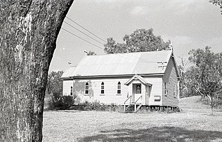
Clontarf is a rural locality in the Toowoomba Region, Queensland, Australia. In the 2021 census, Clontarf had a population of 28 people.

<span class="mw-page-title-main">Bongeen, Queensland</span> Suburb of Toowoomba Region, Queensland, Australia

Bongeen is a rural locality in the Toowoomba Region, Queensland, Australia. In the 2016 census, Bongeen had a population of 75 people.

Kooroongarra is a rural town and locality in the Toowoomba Region, Queensland, Australia. In the 2016 census, the locality of Kooroongarra had a population of 58 people.

Turallin is a rural town and locality in the Toowoomba Region, Queensland, Australia. In the 2021 census, the locality of Turallin had a population of 64 people.

Millmerran Woods is a locality in the Toowoomba Region, Queensland, Australia. In the 2016 census, Millmerran Woods had a population of 92 people.

Millmerran Downs is a locality in the Toowoomba Region, Queensland, Australia. In the 2016 census, Millmerran Downs had a population of 89 people.

Cypress Gardens is a rural residential locality in the Toowoomba Region, Queensland, Australia. In the 2021 census, Cypress Gardens had a population of 94 people.

Forest Ridge is a rural locality in the Toowoomba Region, Queensland, Australia. In the 2016 census, Forest Ridge had a population of 49 people.

Condamine Farms is a rural locality in the Toowoomba Region, Queensland, Australia. In the 2021 census, Condamine Farms had a population of 28 people.

The Pines is a locality in the Toowoomba Region, Queensland, Australia. In the 2016 census, The Pines had a population of 48 people.

Condamine Plains is a rural locality in the Toowoomba Region, Queensland, Australia. In the 2021 census, Condamine Plains had a population of 101 people.

Kurrowah is a rural locality in the Toowoomba Region, Queensland, Australia. In the 2016 census, Kurrowah had a population of 25 people.

Grassdale is a rural locality in the Toowoomba Region, Queensland, Australia. In the 2021 census, Grassdale had a population of 5 people.

References

  1. Australian Bureau of Statistics (28 June 2022). "Dunmore (Qld) (Suburb and Locality)". Australian Census 2021 QuickStats. Retrieved 28 June 2022.  OOjs UI icon edit-ltr-progressive.svg
  2. 1 2 "Dunmore – locality in Toowoomba Region (entry 47932)". Queensland Place Names. Queensland Government . Retrieved 11 June 2019.
  3. 1 2 Australian Bureau of Statistics (28 June 2022). "Dunmore (SAL)". 2021 Census QuickStats. Retrieved 28 February 2023. OOjs UI icon edit-ltr-progressive.svg
  4. 1 2 3 "Queensland Globe". State of Queensland . Retrieved 3 September 2023.
  5. Australian Bureau of Statistics (27 June 2017). "Dunmore (SSC)". 2016 Census QuickStats. Retrieved 20 October 2018. OOjs UI icon edit-ltr-progressive.svg