Blue Mountain Heights is a residential locality in the Toowoomba Region, Queensland, Australia. In the 2021 census, Blue Mountain Heights had a population of 988 people.
Finnie is a rural locality in the Toowoomba Region, Queensland, Australia. In the 2021 census, Finnie had a population of 69 people.
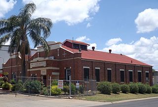
North Toowoomba is a suburban locality in Toowoomba in the Toowoomba Region, Queensland, Australia. In the 2021 census, North Toowoomba had a population of 3,332 people.
Prince Henry Heights is a residential locality on the outskirts of Toowoomba in the Toowoomba Region, Queensland, Australia. In the 2021 census, Prince Henry Heights had a population of 600 people.
Wutul is a rural locality in the Toowoomba Region, Queensland, Australia. In the 2021 census, Wutul had a population of 57 people.
Cattle Creek is a rural locality in the Toowoomba Region, Queensland, Australia. In the 2021 census, Cattle Creek had a population of 21 people.
Coalbank is a rural locality in the Toowoomba Region, Queensland, Australia. In the 2021 census, Coalbank had a population of 45 people.
Tipton is a rural locality in the Toowoomba Region, Queensland, Australia. In the 2021 census, Tipton had a population of 37 people.

Tummaville is a rural locality in the Toowoomba Region, Queensland, Australia. In the 2021 census, Tummaville had a population of 55 people.
Punchs Creek is a rural locality in the Toowoomba Region, Queensland, Australia. In the 2021 census, Punchs Creek had a population of 35 people.
Wattle Ridge is a locality in the Toowoomba Region, Queensland, Australia. In the 2021 census, Wattle Ridge had a population of 21 people.
Forest Ridge is a rural locality in the Toowoomba Region, Queensland, Australia. In the 2021 census, Forest Ridge had a population of 30 people.
Mountain Camp is a rural locality in the Toowoomba Region, Queensland, Australia. In the 2021 census, Mountain Camp had a population of 24 people.
Upper Cooyar Creek is a rural locality in the Toowoomba Region, Queensland, Australia. In the 2021 census, Upper Cooyar Creek had a population of 16 people.
St Aubyn is a rural locality in the Toowoomba Region, Queensland, Australia. In the 2021 census, St Aubyn had a population of 14 people.
Mount Luke is a rural locality in the Toowoomba Region, Queensland, Australia. In the 2021 census, Mount Luke had a population of 51 people.
The Bluff is a rural locality in the Toowoomba Region, Queensland, Australia. In the 2021 census, The Bluff had "no people or a very low population".
Mount Moriah is a rural locality in the Toowoomba Region, Queensland, Australia. In the 2021 census, Mount Moriah had a population of 9 people.
Wainui is a rural locality in the Toowoomba Region, Queensland, Australia. In the 2021 census, Wainui had a population of 8 people.
Woolmer is a rural locality in the Toowoomba Region, Queensland, Australia. In the 2021 census, Woolmer had a population of 38 people.
