
Yarraman is a rural town and locality in the Toowoomba Region, Queensland, Australia. In the 2021 census, the locality of Yarraman had a population of 1,127 people.

Nanango is a rural town and locality in the South Burnett Region, Queensland, Australia. In the 2021 census, the locality of Nanango had a population of 3,679 people.
Peranga is a rural town and locality in the Toowoomba Region, Queensland, Australia. In the 2016 census the locality of Peranga had a population of 85 people.
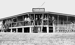
The Cooyar railway line was a branch line in the Darling Downs region of Queensland, Australia. The small town of Cooyar is about halfway to Kingaroy in the South Burnett Region. A plan to connect Kingaroy to the south via Cooyar did not eventuate and left Cooyar at the terminus of a branch line running from Oakey west of Toowoomba.
Moola is a rural locality in the Western Downs Region, Queensland, Australia. In the 2016 census Moola had a population of 123 people.

Quinalow is a rural town and locality in the Toowoomba Region, Queensland, Australia. In the 2016 census the locality of Quinalow had a population of 173 people.
Tarong is a rural locality in the South Burnett Region, Queensland, Australia. In the 2021 census, Tarong had a population of 193 people.
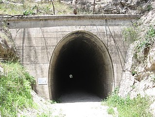
Muntapa Tunnel is a heritage-listed tunnel from Narko-Nutgrove Road, Highgrove through to Nutgrove, both in the Toowoomba Region, Queensland, Australia. It was designed by Queensland Railways and built from 1910 to 1913 by Queensland Railways. It was added to the Queensland Heritage Register on 3 May 2007.

Maclagan is a rural town and locality in the Toowoomba Region, Queensland, Australia. In the 2016 census the locality of Maclagan had a population of 195 people.
Upper Yarraman is a rural locality in the Toowoomba Region, Queensland, Australia. In the 2016 census, Upper Yarraman had a population of 104 people.
Kulpi is a rural town and locality in the Toowoomba Region, Queensland, Australia. In the 2016 census, the locality of Kulpi had a population of 77 people.
Nutgrove is a rural locality in the Toowoomba Region, Queensland, Australia. In the 2016 census Nutgrove had a population of 32 people.
Highgrove is a rural locality in the Toowoomba Region, Queensland, Australia. In the 2016 census Highgrove had a population of 29 people.

Wengenville is a rural locality in the South Burnett Region, Queensland, Australia. In the 2021 census, Wengenville had a population of 54 people.

Highland Plains is a rural locality in the Toowoomba Region, Queensland, Australia. In the 2021 census, Highland Plains had a population of 60 people.
East Cooyar is a rural locality in the Toowoomba Region, Queensland, Australia. In the 2021 census, East Cooyar had a population of 27 people.
Emu Creek is a rural locality in the Toowoomba Region, Queensland, Australia. In the 2021 census, Emu Creek had a population of 113 people.
Narko is a rural locality in the Toowoomba Region, Queensland, Australia. In the 2021 census, Narko had a population of 16 people.
Oakey–Cooyar Road is a continuous 58.8 kilometres (36.5 mi) road route in the Darling Downs and Toowoomba regions of Queensland, Australia. The entire route is signed as State Route 68. It is a state-controlled part regional and part district road. It provides an alternate route between the Warrego Highway and the New England Highway, bypassing Toowoomba.
The roads that join the towns of Dalby, Oakey and Cooyar form a triangle that encloses some of the most fertile land on the Darling Downs in Queensland, Australia. These roads are the Warrego Highway, Oakey–Cooyar Road and Dalby–Cooyar Road. Several of the more significant internal roads intersect with Dalby–Cooyar Road, and these are briefly described in this article, along with some significant external roads.


