Helidon is a rural town and locality in the Lockyer Valley Region, Queensland, Australia. In the 2021 census, the locality of Helidon had a population of 1,130 people.
Clarendon is a rural locality in the Somerset Region, Queensland, Australia. In the 2021 census, Clarendon had a population of 232 people.

Murphys Creek is a rural town and locality in the Lockyer Valley Region, Queensland, Australia. In the 2021 census, the locality of Murphys Creek had a population of 633 people.

Brooloo is a rural town and locality in the Gympie Region, Queensland, Australia. In the 2021 census, the locality of Brooloo had a population of 369 people.
Blue Mountain Heights is a residential locality in the Toowoomba Region, Queensland, Australia. In the 2021 census, Blue Mountain Heights had a population of 988 people.

Ballard is a rural locality in the Lockyer Valley Region, Queensland, Australia. In the 2021 census, Ballard had a population of 167 people.
Finnie is a rural locality in the Toowoomba Region, Queensland, Australia. In the 2021 census, Finnie had a population of 69 people.
Cranley is a rural locality in the Toowoomba Region, Queensland, Australia. In the 2021 census, Cranley had a population of 2,281 people.

Harlaxton is a locality in the Toowoomba Region, Queensland, Australia. Historically a rural area, most of the locality is now residential. In the 2021 census, Harlaxton had a population of 2,824 people.
Preston is a rural locality split between the Toowoomba Region and the Lockyer Valley Region in Queensland, Australia. IIn the 2021 census, Preston had a population of 644 people.

West Haldon is a locality split between Toowoomba Region and Lockyer Valley Region in Queensland, Australia. In the 2021 census, West Haldon had a population of 63 people.
Lawes is a rural locality in the Lockyer Valley Region, Queensland, Australia. In the 2021 census, Lawes had a population of 105 people.
Basalt is a rural locality in the Charters Towers Region, Queensland, Australia. In the 2021 census, Basalt had a population of 215 people.
Lockyer is a rural locality in the Lockyer Valley Region, Queensland, Australia. In the 2021 census, Lockyer had a population of 89 people.
Upper Lockyer is a rural locality in the Lockyer Valley Region, Queensland, Australia. In the 2021 census, Upper Lockyer had a population of 542 people.
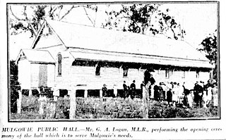
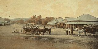
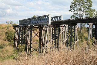
Mulgowie is a rural locality in the Lockyer Valley Region, Queensland, Australia. In the 2021 census, Mulgowie had a population of 166 people.
Rockmount is a rural locality in the Lockyer Valley Region, Queensland, Australia. In the 2021 census, Rockmount had a population of 82 people.
Yargullen is a rural locality in the Toowoomba Region, Queensland, Australia. In the 2021 census, Yargullen had a population of 27 people.
Regency Downs is a mixed-use locality in the Lockyer Valley Region, Queensland, Australia. In the 2021 census, Regency Downs had a population of 2,623 people, an increase of 12% from the 2016 census.
The Bluff is a rural locality in the Toowoomba Region, Queensland, Australia. In the 2021 census, The Bluff had "no people or a very low population".


