Greenmount, Queensland (Toowoomba Region)

Last updated

Map all coordinates using: OpenStreetMap  
Download coordinates as: KML
Greenmount
Queensland
Greenmount War Memorial.jpg
Greenmount war memorial
Australia Queensland location map.svg
Red pog.svg
Greenmount
Coordinates 27°47′09″S151°54′18″E / 27.7858°S 151.905°E / -27.7858; 151.905 (Greenmount (town centre)) Coordinates: 27°47′09″S151°54′18″E / 27.7858°S 151.905°E / -27.7858; 151.905 (Greenmount (town centre))
Population699 (2016 census locality) [1]
 • Density14.383/km2 (37.25/sq mi)
Postcode(s) 4359
Area48.6 km2 (18.8 sq mi)
Time zone AEST (UTC+10:00)
Location
LGA(s) Toowoomba Region
State electorate(s) Condamine
Federal division(s) Groom
Localities around Greenmount:
Cambooya Cambooya East Greenmount
Felton Greenmount East Greenmount
Nobby Nobby Nobby

Greenmount is a rural town and locality in the Toowoomba Region, Queensland, Australia. [2] [3] In the 2016 census, the locality of Greenmount had a population of 699 people. [1]

Contents

Geography

Greenmount is a rural town on the Darling Downs. It is located just off the New England Highway 32 kilometres (20 mi) south of the regional city of Toowoomba.

History

Greenmount was formerly known as Greenmount West, and prior to that as Emu Creek. It takes its present name from the property owned by Donald Mackintosh, a local farmer and Member of the Queensland Legislative Assembly. [2]

The region was settled by graziers in the 1840s; farming activities remain the chief source of employment in Greenmount today. [4]

Greenmount Presbyterian Church opened on Sunday 11 July 1886. [5] [6]

Greenmount Provisional School opened on 10 September 1901. On 1 January 1909, it became Greenmount State School. [7]

The Greenmount War Memorial was dedicated on 11 December 1922 by Queensland Governor, Matthew Nathan. [8]

At the 2006 census, the locality of Greenmount had a population of 336 people. [9]

In the 2016 census, the locality of Greenmount had a population of 699 people. [1]

Heritage listings

Greenmount has a number of heritage-listed sites, including:

Education

Greenmount State School is a government primary (Prep-6) school for boys and girls at Haldon Street ( 27°47′21″S151°54′24″E / 27.7893°S 151.9067°E / -27.7893; 151.9067 (Greenmount State School) ). [11] [12] In 2018, the school had an enrolment of 46 students with 5 teachers (3 full-time equivalent) and 6 non-teaching staff (3 full-time equivalent). [13]

There are no secondary schools in Greenmount. The nearest secondary schools are Clifton State High School in Clifton to the south and Harristown State High School in Harristown, Toowoomba, to the north. [14]

Amenities

Library services in Greenmount are provided by the Toowoomba Regional Council's mobile library service. The van visits Pilton Street every Friday. [15]

Greenmount features a number of parks, including:

Notable residents

Author Steele Rudd (Arthur Hoey Davis), of Dad and Dave fame, lived in the region and attended Emu Creek State School, a nearby school, until the age of twelve. [19] Also, Queensland artist Rex Backhaus-Smith lived there with his family in the 1970s. [20] [21] [22]

Related Research Articles

<span class="mw-page-title-main">Clifton, Queensland</span> Town in Queensland, Australia

Clifton is a rural town and locality in the Toowoomba Region, Queensland, Australia. In the 2016 census, Clifton had a population of 1,456 people.

Glenvale is a rural locality in the Toowoomba Region, Queensland, Australia. It is a suburb of Toowoomba. In the 2016 census, Glenvale had a population of 6,353 people.

Darling Heights is a rural residential locality in the Toowoomba Region, Queensland, Australia. In the 2016 census, Darling Heights had a population of 5,192 people.

<span class="mw-page-title-main">Cambooya, Queensland</span> Town in Queensland, Australia

Cambooya is a rural town and locality in the Toowoomba Region, Queensland, Australia. In the 2016 census the locality of Cambooya had a population of 1,584 people.

Wyreema is a rural town and locality in the Toowoomba Region, Queensland, Australia. In the 2016 census, the locality of Wyreema had a population of 1,834 people.

<span class="mw-page-title-main">Kingsthorpe, Queensland</span> Town in Queensland, Australia

Kingsthorpe is a rural town and locality in the Toowoomba Region, Queensland, Australia. In the 2021 census, the locality of Kingsthorpe had a population of 2,159 people.

<span class="mw-page-title-main">Goombungee, Queensland</span> Town in Queensland, Australia

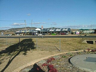
Goombungee is a rural town and locality in the Toowoomba Region, Queensland, Australia. In the 2016 census the locality of Goombungee had a population of 1,026 people.

<span class="mw-page-title-main">Vale View, Queensland</span> Suburb of Toowoomba, Queensland, Australia

Vale View is a rural locality in the Toowoomba Region, Queensland, Australia. In the 2016 census, Vale View had a population of 472 people.

Top Camp is a locality in the Toowoomba Region, Queensland, Australia. In the 2016 census, Top Camp had a population of 852 people.

<span class="mw-page-title-main">Wellcamp, Queensland</span> Suburb of Toowoomba Region, Queensland, Australia

Wellcamp is a rural locality in the Toowoomba Region, Queensland, Australia. In the 2016 census, Wellcamp had a population of 295 people.

<span class="mw-page-title-main">Harristown, Queensland</span> Suburb of Toowoomba, Queensland, Australia

Harristown is a residential locality in Toowoomba in the Toowoomba Region, Queensland, Australia. In the 2016 census, Harristown had a population of 8,555 people.

Hodgson Vale is a rural locality in the Toowoomba Region, Queensland, Australia. In the 2016 census, Hodgson Vale had a population of 1,379 people.

<span class="mw-page-title-main">Mount Lofty, Queensland</span> Suburb of Toowoomba, Queensland, Australia

Mount Lofty is a residential locality on the north-eastern edge of the suburban area of Toowoomba, in the Toowoomba Region, Queensland, Australia. In the 2016 census, Mount Lofty had a population of 3,775 people.

<span class="mw-page-title-main">Newtown, Queensland (Toowoomba)</span> Suburb of Toowoomba, Queensland, Australia

Newtown is a residential locality in Toowoomba in the Toowoomba Region, Queensland, Australia. In the 2021 census, Newtown had a population of 10,039 people.

<span class="mw-page-title-main">Westbrook, Queensland</span> Suburb of Toowoomba Region, Queensland, Australia

Westbrook is a rural town and locality in the Toowoomba Region, Queensland, Australia. In the 2016 census, the locality of Westbrook had a population of 3,885 people.

<span class="mw-page-title-main">East Greenmount, Queensland</span> Suburb of Toowoomba Region, Queensland, Australia

East Greenmount is a rural town and locality in the Toowoomba Region, Queensland, Australia. In the 2016 census, the locality of East Greenmount had a population of 361 people.

<span class="mw-page-title-main">Ascot, Queensland (Toowoomba Region)</span> Suburb of Toowoomba Region, Queensland, Australia

Ascot is a rural locality in the Toowoomba Region, Queensland, Australia. In the 2016 census, Ascot had a population of 31 people.

<span class="mw-page-title-main">Maclagan, Queensland</span> Town in Queensland, Australia

Maclagan is a rural town and locality in the Toowoomba Region, Queensland, Australia. In the 2016 census the locality of Maclagan had a population of 195 people.

<span class="mw-page-title-main">Felton, Queensland</span> Suburb of Toowoomba Region, Queensland, Australia

Felton is a rural locality in the Toowoomba Region, Queensland, Australia. In the 2016 census, Felton had a population of 276 people.

Ramsay is a rural locality in the Toowoomba Region, Queensland, Australia. In the 2016 census Ramsay had a population of 348 people.

References

  1. 1 2 3 Australian Bureau of Statistics (27 June 2017). "Greenmount (SSC)". 2016 Census QuickStats. Retrieved 20 October 2018. OOjs UI icon edit-ltr-progressive.svg
  2. 1 2 "Greenmount – town in Toowoomba Region (entry 14787)". Queensland Place Names. Queensland Government . Retrieved 29 December 2020.
  3. "Greenmount – locality in Toowoomba Region (entry 50181)". Queensland Place Names. Queensland Government . Retrieved 29 December 2020.
  4. Sydney Morning Herald Archived 11 February 2007 at the Wayback Machine – Travel Page
  5. "Greenmount Presbyterian Church". Darling Downs Gazette . Vol. XXX, no. 5, 952. Queensland, Australia. 17 July 1886. p. 3. Retrieved 13 December 2021 via National Library of Australia.
  6. "Advertising". Toowoomba Chronicle And Darling Downs General Advertiser . No. 3452. Queensland, Australia. 6 March 1886. p. 6. Retrieved 13 December 2021 via National Library of Australia.
  7. Queensland Family History Society (2010), Queensland schools past and present (Version 1.01 ed.), Queensland Family History Society, ISBN   978-1-921171-26-0
  8. "Greenmount War Memorial". Monument Australia. Archived from the original on 7 April 2014. Retrieved 5 April 2014.
  9. Australian Bureau of Statistics (25 October 2007). "Greenmount (SSC)". 2006 Census QuickStats. Retrieved 22 January 2021.
  10. "Greenmount War Memorial (entry 600390)". Queensland Heritage Register . Queensland Heritage Council. Retrieved 15 July 2013.
  11. "State and non-state school details". Queensland Government. 9 July 2018. Archived from the original on 21 November 2018. Retrieved 21 November 2018.
  12. "Greenmount State School". Archived from the original on 22 January 2021. Retrieved 21 November 2018.
  13. "ACARA School Profile 2018". Australian Curriculum, Assessment and Reporting Authority. Archived from the original on 27 August 2020. Retrieved 28 January 2020.
  14. "Queensland Globe". State of Queensland . Retrieved 22 January 2021.
  15. "Mobile library". Toowoomba Regional Council. Archived from the original on 24 October 2014. Retrieved 10 November 2014.
  16. 1 2 "Land for public recreation - Queensland". Queensland Open Data. Queensland Government. 20 November 2020. Archived from the original on 22 November 2020. Retrieved 22 November 2020.
  17. "Greenmount - Bicentennial Memorial Park". Toowoomba Regional Council . 1 October 2020. Retrieved 22 January 2021.
  18. "Jack Derrick Park". Toowoomba Regional Council . 6 October 2020. Retrieved 22 January 2021.
  19. Dictionary of Australian Biography Archived 28 March 2016 at the Wayback Machine – Steele Rudd
  20. "Rex Backhaus-Smith". Art on Cairncross. Archived from the original on 12 March 2018. Retrieved 26 April 2018.
  21. AndrewBackhouse. "Darling Heights house hides fascinating history". Chronicle. Archived from the original on 26 October 2016. Retrieved 26 April 2018.
  22. "Rex Backhaus Smith - Painting Life". www.usc.edu.au. Archived from the original on 26 April 2018. Retrieved 26 April 2018.