
Nobby is a rural town and locality on the Darling Downs in the Toowoomba Region, Queensland, Australia. It is located halfway between Toowoomba and Warwick. It is known for its association with Steele Rudd (author) and Sister Elizabeth Kenny.
Gatton is a rural town and locality in the Lockyer Valley Region, Queensland, Australia. It is the administrative centre of the Lockyer Valley Region, situated in the Lockyer Valley of South East Queensland.

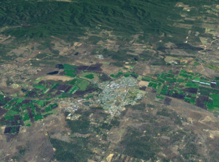
Greenmount is a rural town and locality in the Toowoomba Region, Queensland, Australia. In the 2021 census, the locality of Greenmount had a population of 765 people.

Pilton is a rural town and locality in the Toowoomba Region, Queensland, Australia. It is south of the city of Toowoomba. In the 2021 census, the locality of Pilton had a population of 71 people.
Blanchview is a rural locality in the Lockyer Valley Region, Queensland, Australia. In the 2021 census, Blanchview had a population of 202 people.

Aubigny is a rural town and locality in the Toowoomba Region, Queensland, Australia. In the 2021 census, the locality of Aubigny had a population of 283 people.

Mount Whitestone is a rural locality in the Lockyer Valley Region, Queensland, Australia. In the 2021 census, Mount Whitestone had a population of 129 people.

Fordsdale is a rural locality in the Lockyer Valley Region, Queensland, Australia. In the 2021 census, Fordsdale had a population of 50 people.

West Haldon is a locality split between Toowoomba Region and Lockyer Valley Region in Queensland, Australia. In the 2021 census, West Haldon had a population of 63 people.

Hirstglen is a rural locality in the Toowoomba Region on the Darling Downs, Queensland, Australia. In the 2021 census, Hirstglen had a population of 77 people.

Ascot is a rural locality in the Toowoomba Region, Queensland, Australia. In the 2021 census, Ascot had a population of 106 people.

Spring Creek is a rural locality split between the Toowoomba Region and the Southern Downs Region, Queensland, Australia. In the 2021 census, Spring Creek had a population of 195 people.
Ramsay is a rural locality in the Toowoomba Region, Queensland, Australia. In the 2021 census, Ramsay had a population of 369 people.
Manapouri is a rural locality in the Toowoomba Region, Queensland, Australia. In the 2021 census, Manapouri had a population of 47 people.
Coalbank is a rural locality in the Toowoomba Region, Queensland, Australia. In the 2021 census, Coalbank had a population of 45 people.
Nevilton is a rural locality in the Toowoomba Region, Queensland, Australia. In the 2021 census, Nevilton had a population of 25 people.
Norwin is a rural locality in the Toowoomba Region, Queensland, Australia. In the 2021 census, Norwin had a population of 100 people.

Tummaville is a rural locality in the Toowoomba Region, Queensland, Australia. In the 2021 census, Tummaville had a population of 55 people.
Upper Pilton is a rural locality split between the Toowoomba Region and the Southern Downs Region, both in Queensland, Australia. In the 2021 census, Upper Pilton had a population of 80 people.
Gatton–Clifton Road is a continuous 63.1 kilometres (39.2 mi) road route in the Lockyer Valley and Toowoomba regions of Queensland, Australia. Most of the road is signed as State Route 80. Gatton–Clifton Road is a state-controlled road, part regional and part district. The district part is rated as a local road of regional significance (LRRS).


