
Quinalow is a rural town and locality in the Toowoomba Region, Queensland, Australia. In the 2021 census, the locality of Quinalow had a population of 205 people.
Blue Mountain Heights is a residential locality in the Toowoomba Region, Queensland, Australia. In the 2021 census, Blue Mountain Heights had a population of 988 people.
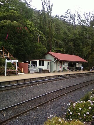
Spring Bluff is a rural locality in the Toowoomba Region, Queensland, Australia. In the 2021 census, Spring Bluff had "no people or a very low population".

Ascot is a rural locality in the Toowoomba Region, Queensland, Australia. In the 2021 census, Ascot had a population of 106 people.
Grapetree is a rural locality in the Toowoomba Region, Queensland, Australia. In the 2021 census, Grapetree had a population of 42 people.
Cattle Creek is a rural locality in the Toowoomba Region, Queensland, Australia. In the 2021 census, Cattle Creek had a population of 21 people.
Rocky Creek is a rural locality in the Toowoomba Region, Queensland, Australia. In the 2021 census, Rocky Creek had a population of 35 people.
Punchs Creek is a rural locality in the Toowoomba Region, Queensland, Australia. In the 2021 census, Punchs Creek had a population of 35 people.
Mount Binga is a rural locality in the Toowoomba Region, Queensland, Australia. In the 2021 census, Mount Binga had a population of 86 people.
Gilla is a rural locality in the Toowoomba Region, Queensland, Australia. In the 2021 census, Gilla had a population of 61 people.
Googa Creek is a rural locality in the Toowoomba Region, Queensland, Australia. In the 2021 census, Googa Creek had a population of 54 people.
Helidon Spa is a rural locality in the Lockyer Valley Region, Queensland, Australia. In the 2021 census, Helidon Spa had a population of 504 people.
Bulli Creek is a rural locality in the Toowoomba Region, Queensland, Australia. In the 2021 census, Bulli Creek had "no people or a very low population".
Wattle Ridge is a locality in the Toowoomba Region, Queensland, Australia. In the 2021 census, Wattle Ridge had a population of 21 people.
Cressbrook Creek is a rural locality in the Toowoomba Region, Queensland, Australia. In the 2021 census, Cressbrook Creek had a population of 10 people.
East Cooyar is a rural locality in the Toowoomba Region, Queensland, Australia. In the 2021 census, East Cooyar had a population of 27 people.
Upper Cooyar Creek is a rural locality in the Toowoomba Region, Queensland, Australia. In the 2021 census, Upper Cooyar Creek had a population of 16 people.
Grays Gate is a rural locality in the Toowoomba Region, Queensland, Australia. In the 2021 census, Grays Gate had a population of 28 people.
Merritts Creek is a rural locality in the Toowoomba Region, Queensland, Australia. In the 2021 census, Merritts Creek had a population of 102 people.
Woolmer is a rural locality in the Toowoomba Region, Queensland, Australia. In the 2021 census, Woolmer had a population of 38 people.
