
Darling Heights is a rural residential locality in the Toowoomba Region, Queensland, Australia. In the 2021 census, Darling Heights had a population of 5,157 people.

Eerwah Vale is a locality split between the Sunshine Coast Region and Shire of Noosa, both in Queensland, Australia. In the 2021 census, Eerwah Vale had a population of 671 people.
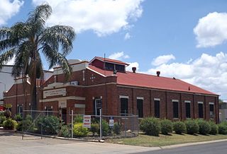
Wyreema is a rural town and locality in the Toowoomba Region, Queensland, Australia. In the 2021 census, the locality of Wyreema had a population of 2,076 people.
Birnam is a rural locality in the Toowoomba Region, Queensland, Australia. In the 2021 census, Birnam had a population of 63 people.
Mount Rascal is a rural locality in the Toowoomba Region, Queensland, Australia. In the 2021 census, Mount Rascal had a population of 393 people.

Vale View is a rural locality in the Toowoomba Region, Queensland, Australia. In the 2021 census, Vale View had a population of 454 people.
Cranley is a rural locality in the Toowoomba Region, Queensland, Australia. In the 2021 census, Cranley had a population of 2,281 people.
Top Camp is a locality in the Toowoomba Region, Queensland, Australia. In the 2021 census, Top Camp had a population of 902 people.

Charlton is a rural locality in the Toowoomba Region, Queensland, Australia, located 13 kilometres (8 mi) west from the Toowoomba city centre off the Warrego Highway.. In the 2021 census, Charlton had a population of 107 people.

Wellcamp is a rural locality in the Toowoomba Region, Queensland, Australia. In the 2021 census, Wellcamp had a population of 346 people.

Harristown is a residential locality in Toowoomba in the Toowoomba Region, Queensland, Australia. In the 2021 census, Harristown had a population of 9,081 people.
Hodgson Vale is a rural locality in the Toowoomba Region, Queensland, Australia. In the 2021 census, Hodgson Vale had a population of 1,444 people.
Kearneys Spring is a residential locality in Toowoomba in the Toowoomba Region, Queensland, Australia. In the 2021 census, Kearneys Spring had a population of 9,419 people.
Preston is a rural locality split between the Toowoomba Region and the Lockyer Valley Region in Queensland, Australia. IIn the 2021 census, Preston had a population of 644 people.
North Toowoomba is a suburban locality in Toowoomba in the Toowoomba Region, Queensland, Australia. In the 2021 census, North Toowoomba had a population of 3,332 people.

Redwood is a rural locality on the outskirts of Toowoomba in the Toowoomba Region, Queensland, Australia. In the 2021 census, Redwood had a population of 159 people.

Athol is a rural locality in the Toowoomba Region, Queensland, Australia. In the 2021 census, Athol had a population of 139 people.

East Greenmount is a rural town and locality in the Toowoomba Region, Queensland, Australia. In the 2021 census, the locality of East Greenmount had a population of 351 people.

Umbiram is a rural locality in the Toowoomba Region, Queensland, Australia. In the 2021 census, Umbiram had a population of 146 people.
Regency Downs is a mixed-use locality in the Lockyer Valley Region, Queensland, Australia. In the 2021 census, Regency Downs had a population of 2,623 people, an increase of 12% from the 2016 census.

