Nutgrove, Queensland

Last updated

Map all coordinates using: OpenStreetMap  
Download coordinates as: KML  ·  GPX
Nutgrove
Queensland
Australia Queensland location map.svg
Red pog.svg
Nutgrove
Coordinates 27°02′56″S151°45′19″E / 27.0488°S 151.7552°E / -27.0488; 151.7552 (Nutgrove (centre of locality))
Population32 (2016 census) [1]
 • Density1.379/km2 (3.57/sq mi)
Postcode(s) 4352
Area23.2 km2 (9.0 sq mi)
Time zone AEST (UTC+10:00)
Location
LGA(s) Toowoomba Region
State electorate(s) Nanango
Federal Division(s)
Suburbs around Nutgrove:
Upper Cooyar Creek Upper Cooyar Creek Wutul
Maclagan Nutgrove Wutul
Narko Highgrove Thornville

Nutgrove is a rural locality in the Toowoomba Region, Queensland, Australia. [2] In the 2016 census Nutgrove had a population of 32 people. [1]

Contents

History

The Cooyar railway line opened to Nutgrove on 28 April 1913 with the locality served by the Nutgrove railway station, [3] located immediately to the north of Douglas Nutgrove Road ( 27°02′40″S151°46′28″E / 27.04446°S 151.77439°E / -27.04446; 151.77439 (Nutgrove railway station) ), now in Wutul. [4] [5] [6]

Nutgrove State School opened on 20 June 1923 and closed on 1947. [7] It was located at 5779 Dalby Cooyar Road ( 27°03′03″S151°45′30″E / 27.05085°S 151.75841°E / -27.05085; 151.75841 (Nutgrove State School (former)) ). [4] [5] [6]

In the 2016 census Nutgrove had a population of 32 people. [1]

Heritage listings

Nutgrove has a number of heritage-listed sites, including:

Economy

There are a number of homesteads in the locality: [9]

Education

There are no schools in Nutgrove. The nearest primary school is Cooyar State School in Cooyar to the north-east. The nearest secondary school is Quinalow State School (offering schooling up to Year 10) in Quinalow to the south-west with the more distant Oakey State High School in Oakey to the south offering schooling up to Year 12. [10]

Related Research Articles

Oakey, Queensland Town in Queensland, Australia

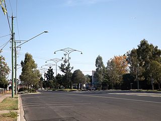
Oakey is a rural town and locality in the Toowoomba Region, Queensland, Australia. In the 2016 census, Oakey had a population of 4,705 people.

Gowrie Junction, Queensland Suburb of Toowoomba Region, Queensland, Australia

Gowrie Junction is a rural locality in the Toowoomba Region, Queensland, Australia. It is north-west of Toowoomba. In the 2016 census, Gowrie Junction had a population of 2,120 people. The town of Gowrie is in the eastern part of the locality.

Peranga, Queensland Town in Queensland, Australia

Peranga is a town and a locality in the Toowoomba Region, Queensland, Australia.

Cecil Plains, Queensland Town in Queensland, Australia

Cecil Plains is a rural town and locality in the Toowoomba Region, Queensland, Australia. In the 2016 census, Cecil Plains had a population of 429 people.

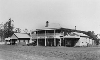
The Cooyar railway line was a branch line in the Darling Downs region of Queensland, Australia. The small town of Cooyar is about halfway to Kingaroy in the South Burnett Region. A plan to connect Kingaroy to the south via Cooyar did not eventuate and left Cooyar at the terminus of a branch line running from Oakey west of Toowoomba. It was opened on 28 April 1913 after previous stages to Kulpi and Peranga opened on 29 April 1912 and 4 November 1912 respectively. The line was partially closed beyond Acland on 1 May 1964, with the last segment closed on 8 December 1969.

Cooyar, Queensland Town in Queensland, Australia

Cooyar is a rural town and locality in the Toowoomba Region, Queensland, Australia. In the 2016 census, Cooyar had a population of 224 people.

Haden, Queensland Town in Queensland, Australia

Haden is a rural town and locality in the Toowoomba Region, Queensland, Australia. In the 2016 census, Haden had a population of 195 people.

Muntapa Tunnel

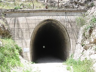
Muntapa Tunnel is a heritage-listed tunnel from Narko-Nutgrove Road, Highgrove through to Nutgrove, both in the Toowoomba Region, Queensland, Australia. It was designed by Queensland Railways and built from 1910 to 1913 by Queensland Railways. It was added to the Queensland Heritage Register on 3 May 2007.

Boodua, Queensland Suburb of Toowoomba Region, Queensland, Australia

Boodua is a locality in the Toowoomba Region local government area on the Darling Downs in southern Queensland, Australia. At the 2016 Australian census, Boodua had a population of 93.

Evanslea, Queensland Suburb of Toowoomba Region, Queensland, Australia

Evanslea is a rural locality in the Toowoomba Region, Queensland, Australia. In the 2016 census Evanslea had a population of 41 people.

Wutul, Queensland Suburb of Toowoomba Region, Queensland, Australia

Wutul is a rural locality in the Toowoomba Region, Queensland, Australia. In the 2016 census Wutul had a population of 37 people.

Branchview, Queensland Suburb of Toowoomba Region, Queensland, Australia

Branchview is a rural locality in the Toowoomba Region, Queensland, Australia. In the 2016 census Branchview had a population of 17 people.

Formartin, Queensland Suburb of Toowoomba Region, Queensland, Australia

Formartin is a rural locality in the Toowoomba Region, Queensland, Australia. In the 2016 census Formartin had a population of 95 people.

Greenwood, Queensland Suburb of Toowoomba Region, Queensland, Australia

Greenwood is a rural locality in the Toowoomba Region, Queensland, Australia. In the 2016 census Greenwood had a population of 40 people.

Irongate, Queensland Suburb of Toowoomba Region, Queensland, Australia

Irongate is a rural locality in the Toowoomba Region, Queensland, Australia. In the 2016 census Irongate had a population of 119 people.

Kelvinhaugh, Queensland Suburb of Toowoomba Region, Queensland, Australia

Kelvinhaugh is a rural locality in the Toowoomba Region, Queensland, Australia. In the 2016 census Kelvinhaugh had a population of 44 people.

Highgrove, Queensland Suburb of Toowoomba Region, Queensland, Australia

Highgrove is a rural locality in the Toowoomba Region, Queensland, Australia. In the 2016 census Highgrove had a population of 29 people.

Gilla, Queensland Suburb of Toowoomba Region, Queensland, Australia

Gilla is a rural locality in the Toowoomba Region, Queensland, Australia. In the 2016 census Gilla had a population of 32 people.

Kings Siding, Queensland Suburb of Toowoomba Region, Queensland, Australia

Kings Siding is a rural locality in the Toowoomba Region, Queensland, Australia. In the 2016 census Kings Siding had a population of 16 people.

Mount Darry, Queensland Suburb of Toowoomba Region, Queensland, Australia

Mount Darry is a rural locality in the Toowoomba Region, Queensland, Australia. In the 2016 census Mount Darry had a population of 35 people.

References

  1. 1 2 3 Australian Bureau of Statistics (27 June 2017). "Nutgrove (SSC)". 2016 Census QuickStats. Retrieved 20 October 2018. OOjs UI icon edit-ltr-progressive.svg
  2. "Nutgrove – locality in Toowoomba Region (entry 48030)". Queensland Place Names. Queensland Government . Retrieved 29 December 2020.
  3. The Cooyar Branch Line Milne, Rod Australian Railway Historical Society Bulletin, July, 1996 pp195-205
  4. 1 2 "Parish of Cooyar sheet 1" (Map). Queensland Government. 1938. Retrieved 25 January 2021.
  5. 1 2 "Evergreen" (Map). Queensland Government. 1946. Archived from the original on 27 September 2020. Retrieved 25 January 2021.
  6. 1 2 "Queensland Globe". State of Queensland . Retrieved 25 January 2021.
  7. Queensland Family History Society (2010), Queensland schools past and present (Version 1.01 ed.), Queensland Family History Society, ISBN   978-1-921171-26-0
  8. "Muntapa Tunnel (entry 602594)". Queensland Heritage Register . Queensland Heritage Council. Retrieved 15 July 2013.
  9. "Homesteads - Queensland". Queensland Open Data. Queensland Government. 18 November 2020. Archived from the original on 24 November 2020. Retrieved 24 November 2020.
  10. "Queensland Globe". State of Queensland . Retrieved 25 January 2021.