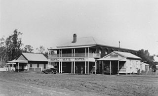
Cooyar is a rural town and locality in the Toowoomba Region, Queensland, Australia. In the 2021 census, the locality of Cooyar had a population of 231 people.
Cotswold Hills is a rural-residential locality within Toowoomba in the Toowoomba Region, Queensland, Australia. In the 2021 census, Cotswold Hills had a population of 1,620 people.

Middle Ridge is a residential locality of Toowoomba in the Toowoomba Region, Queensland, Australia. In the 2021 census, Middle Ridge had a population of 7,595 people.

Mount Kynoch is a rural locality in the Toowoomba Region, Queensland, Australia. In the 2016 census, Mount Kynoch had a population of 237 people.

Geham is a rural locality in the Toowoomba Region, Queensland, Australia. In the 2021 census, Geham had a population of 470 people.

Jondaryan is a rural town and locality in the Toowoomba Region, Queensland, Australia. In the 2016 census, the locality of Jondaryan had a population of 385 people.

Aubigny is a rural town and locality in the Toowoomba Region, Queensland, Australia. In the 2016 census, the locality of Aubigny had a population of 254 people.

Pampas is a rural locality in the Toowoomba Region, Queensland, Australia. In the 2016 census, Pampas had a population of 62 people.

Biddeston is a rural town and locality in the Toowoomba Region, Queensland, Australia. In the 2016 census the locality of Biddeston had a population of 284 people.

Ascot is a rural locality in the Toowoomba Region, Queensland, Australia. In the 2021 census, Ascot had a population of 106 people.

Linthorpe is a rural locality in the Toowoomba Region, Queensland, Australia. In the 2021 census, Linthorpe had a population of 416 people.
Branchview is a rural locality in the Toowoomba Region, Queensland, Australia. In the 2021 census, Branchview had a population of 37 people.
Irongate is a rural locality in the Toowoomba Region, Queensland, Australia. In the 2021 census, Irongate had a population of 135 people.
North Branch is a locality in the Toowoomba Region, Queensland, Australia. In the 2021 census, North Branch had a population of 48 people.
Norwin is a rural locality in the Toowoomba Region, Queensland, Australia. In the 2016 census, Norwin had a population of 94 people.
Nutgrove is a rural locality in the Toowoomba Region, Queensland, Australia. In the 2016 census Nutgrove had a population of 32 people.
Mount Steadman is a rural locality in the North Burnett Region, Queensland, Australia. In the 2016 census Mount Steadman had a population of 8 people.
Muniganeen is a rural locality in the Toowoomba Region, Queensland, Australia. In the 2021 census, Muniganeen had a population of 40 people.
Mount Darry is a rural locality in the Toowoomba Region, Queensland, Australia. In the 2016 census Mount Darry had a population of 35 people.
Narko is a rural locality in the Toowoomba Region, Queensland, Australia. In the 2021 census, Narko had a population of 16 people.
