Mount Irving, Queensland

Last updated

Map all coordinates using: OpenStreetMap  
Download coordinates as: KML
Mount Irving
Queensland
Mount Irving.jpg
Mount Irving, 2014
Australia Queensland location map.svg
Red pog.svg
Mount Irving
Coordinates 27°30′52″S151°34′40″E / 27.5144°S 151.5777°E / -27.5144; 151.5777 Coordinates: 27°30′52″S151°34′40″E / 27.5144°S 151.5777°E / -27.5144; 151.5777
Population15 (2016 census) [1]
 • Density0.872/km2 (2.26/sq mi)
Postcode(s) 4401
Area17.2 km2 (6.6 sq mi)
Time zone AEST (UTC+10:00)
LGA(s) Toowoomba Region
State electorate(s) Condamine
Federal division(s) Groom
Suburbs around Mount Irving:
Evanslea Yargullen Yargullen
Mount Tyson Mount Irving Purrawunda
Mount Tyson Mount Tyson Motley

Mount Irving is a rural locality in the Toowoomba Region, Queensland, Australia. [2] In the 2016 census, Mount Irving had a population of 15 people. [1]

Contents

Geography

Mount Irving is on the Darling Downs.

The mountain Mount Irving is in the north-east of the locality ( 27°30′37″S151°35′26″E / 27.5103°S 151.5906°E / -27.5103; 151.5906 (Mount Irving (Queensland)) ) and its peak is at 463 metres (1,519 ft) above sea level; the surrounding plain being approximately 400 metres (1,300 ft). [3]

History

The locality takes its name from the nearby mountain, which in run was named for Clark Irving of Warra (also known Warra Warra) pastoral run. [2] [4] [3]

Related Research Articles

Gowrie Junction, Queensland Suburb of Toowoomba Region, Queensland, Australia

Gowrie Junction is a rural locality in the Toowoomba Region, Queensland, Australia. It is north-west of Toowoomba. In the 2016 census, Gowrie Junction had a population of 2,120 people. The town of Gowrie is in the eastern part of the locality.

Bell, Queensland Town in Queensland, Australia

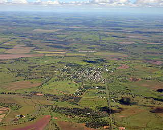
Bell is a rural town and locality in the Western Downs Region, Queensland, Australia. In the 2016 census the locality of Bell had a population of 502 people.

Kingsthorpe, Queensland Town in Queensland, Australia

Kingsthorpe is a rural town and locality in the Toowoomba Region, Queensland, Australia. In the 2016 census, Kingsthorpe had a population of 1,867 people.

Macalister, Queensland Town in Queensland, Australia

Macalister is a rural town and locality in the Western Downs Region, Queensland, Australia. In the 2016 census the locality of Macalister had a population of 153.

Mount Rascal, Queensland Suburb of Toowoomba Region, Queensland, Australia

Mount Rascal is a rural locality in the Toowoomba Region, Queensland, Australia. In the 2016 census, Mount Rascal had a population of 462 people.

Rockville, Queensland Suburb of Toowoomba, Queensland, Australia

Rockville is a residential locality in the Toowoomba Region, Queensland, Australia. In the 2016 census, Rockville had a population of 3,237 people.

Mount Tyson, Queensland Town in Queensland, Australia

Mount Tyson is a rural town and locality in the Toowoomba Region, Queensland, Australia. In the 2016 census, Mount Tyson had a population of 285 people.

East Greenmount, Queensland Suburb of Toowoomba Region, Queensland, Australia

East Greenmount is a rural town and locality in the Toowoomba Region, Queensland, Australia. In the 2016 census the locality of East Greenmount had a population of 361 people.

Ascot, Queensland (Toowoomba Region) Suburb of Toowoomba Region, Queensland, Australia

Ascot is a rural locality in the Toowoomba Region, Queensland, Australia. In the 2016 census, Ascot had a population of 31 people.

Gowrie Little Plain, Queensland Suburb of Toowoomba Region, Queensland, Australia

Gowrie Little Plain is a rural locality in the Toowoomba Region, Queensland, Australia. In the 2016 census, Gowrie Little Plain had a population of 65 people.

Meringandan West, Queensland Suburb of Toowoomba Region, Queensland, Australia

Meringandan West is a rural locality in the Toowoomba Region, Queensland, Australia. In the 2016 census, Meringandan West had a population of 2211 people.

Ramsay, Queensland Suburb of Toowoomba Region, Queensland, Australia

Ramsay is a rural locality in the Toowoomba Region, Queensland, Australia. In the 2016 census Ramsay had a population of 348 people.

Evanslea, Queensland Suburb of Toowoomba Region, Queensland, Australia

Evanslea is a rural locality in the Toowoomba Region, Queensland, Australia. In the 2016 census Evanslea had a population of 41 people.

Brookstead, Queensland Town in Queensland, Australia

Brookstead is a rural town and locality in the Toowoomba Region, Queensland, Australia. In the 2016 census, Brookstead had a population of 217 people.

Mount Emlyn, Queensland Suburb of Toowoomba Region, Queensland, Australia

Mount Emlyn is a rural locality in the Toowoomba Region, Queensland, Australia. In the 2016 census Mount Emlyn had a population of 16 people.

Silverleigh, Queensland Suburb of Toowoomba Region, Queensland, Australia

Silverleigh is a rural locality in the Toowoomba Region, Queensland, Australia. In the 2016 census Silverleigh had a population of 71 people.

Leslie Dam, Queensland Suburb of Southern Downs Region, Queensland, Australia

Leslie Dam is a locality in the Southern Downs Region, Queensland, Australia. In the 2016 census, Leslie Dam had a population of 163 people.

Irvingdale, Queensland Suburb of Toowoomba Region, Queensland, Australia

Irvingdale is a locality split between the Toowoomba Region and the Western Downs Region, both in Queensland, Australia. In the 2016 census, Irvingdale had a population of 194 people.

Kings Creek, Queensland Suburb of Toowoomba Region, Queensland, Australia

Kings Creek is a rural locality in the Toowoomba Region, Queensland, Australia. In the 2016 census, Kings Creek had a population of 72 people.

Kings Siding, Queensland Suburb of Toowoomba Region, Queensland, Australia

Kings Siding is a rural locality in the Toowoomba Region, Queensland, Australia. In the 2016 census Kings Siding had a population of 16 people.

References

  1. 1 2 Australian Bureau of Statistics (27 June 2017). "Mount Irving (SSC)". 2016 Census QuickStats. Retrieved 20 October 2018. OOjs UI icon edit-ltr-progressive.svg
  2. 1 2 "Mount Irving – locality in Toowoomba Region (entry 48010)". Queensland Place Names. Queensland Government . Retrieved 17 November 2019.
  3. 1 2 "Mount Irving – mountain in the Toowoomba Region (entry 16850)". Queensland Place Names. Queensland Government . Retrieved 23 November 2019.
  4. "SOME DOWNS PLACE NAMES". Toowoomba Chronicle and Darling Downs Gazette . LXVII (277). Queensland, Australia. 22 November 1928. p. 19. Retrieved 23 November 2019 via National Library of Australia.