Preston, Queensland

Last updated

Map all coordinates using: OpenStreetMap  
Download coordinates as: KML  ·  GPX
Preston
Toowoomba,  Queensland
Australia Queensland location map.svg
Red pog.svg
Preston
Coordinates 27°39′54″S151°58′05″E / 27.665°S 151.968°E / -27.665; 151.968 (Preston (centre of locality))
Postcode(s) 4352
Location10 km (6 mi) SSE of Toowoomba
LGA(s)
State electorate(s) Condamine
Federal Division(s) Groom
Suburbs around Preston:
Kearneys Spring Middle Ridge Upper Flagstone
Top Camp Preston Rockmount
Hodgson Vale Hodgson Vale Ramsay

Preston is a rural locality split between the Toowoomba Region and the Lockyer Valley Region in Queensland, Australia. [1] [2]

Contents

Geography

Preston is located to the south-east of Toowomba and to the east of Hodgson Vale.

History

Preston Provisional School opened in 1896. It became Preston State School on 1 Jan 1909. In 1925 due to low student numbers, it initially became a half time school in conjunction with Eton Vale State School (a teacher was shared between the two schools) but then closed later in 1925. In April 1930 the school reopened and finally closed in 1947. [3] The school was located approximately at 13 Nass Road ( 27°39′22″S151°58′20″E / 27.6561°S 151.9723°E / -27.6561; 151.9723 (Preston State School (site)) ). [4]

In 2006 St David's Anglican Church was relocated from Oman Ama to 330 Preston Boundary Road in Preston ( 27°38′55″S151°57′48″E / 27.6486°S 151.9634°E / -27.6486; 151.9634 (Preston Manor & Village Chapel) ), where it is used as a wedding chapel at Preston Manor & Village Chapel. [5] The church was dedicated on 31 July 1905 in Oman Ama. [6] It closed in 1972 but reopened on 28 July 1985. Its final closure on 30 July 2002 was approved by Assistant Bishop Nolan. [7]

Community groups

The Middle Ridge branch of the Queensland Country Women's Association meets at 95 Preston-Boundary Road ( 27°38′10″S151°56′58″E / 27.6362°S 151.9494°E / -27.6362; 151.9494 (Middle Ridge QCWA) ). [8]

Related Research Articles

Laidley, Queensland Town in Queensland, Australia

Laidley is a rural town and locality in the Lockyer Valley Region, Queensland, Australia. In the 2016 census, Laidley had a population of 3,808 people.

Shire of Cambooya Local government area in Queensland, Australia

The Shire of Cambooya was a local government area in the Darling Downs region of Queensland, Australia, immediately south of the regional city of Toowoomba. The shire, administered from the town of Greenmount, covered an area of 638.5 square kilometres (246.5 sq mi), and existed as a local government entity from 1914 until 2008, when it amalgamated with several other councils in the Toowoomba area to form the Toowoomba Region.

Cambooya, Queensland Town in Queensland, Australia

Cambooya is a town and locality in the Toowoomba Region, Queensland, Australia. At the 2016 Australian census the town recorded a population of 1,584.

Cabarlah, Queensland Town in Queensland, Australia

Cabarlah is a town and locality in the Toowoomba Region, Queensland, Australia. At the 2016 census, Cabarlah had a population of 1,075.

Centenary Heights, Queensland Suburb of Toowoomba, Queensland, Australia

Centenary Heights is a residential locality in Toowoomba within the Toowoomba Region, Queensland, Australia. In the 2016 census, Centenary Heights had a population of 6,063 people.

Vale View, Queensland Suburb of Toowoomba, Queensland, Australia

Vale View is a rural locality in the Toowoomba Region, Queensland, Australia. In the 2016 census, Vale View had a population of 472 people.

Top Camp, Queensland Suburb of Toowoomba, Queensland, Australia

Top Camp is a locality in the Toowoomba Region, Queensland, Australia. In the 2016 census, Top Camp had a population of 852 people.

Harlaxton, Queensland Suburb of Toowoomba, Queensland, Australia

Harlaxton is a locality in the Toowoomba Region, Queensland, Australia. In the 2016 census, Harlaxton had a population of 2,547 people. Traditionally a rural area, most of the locality is now residential.

Hodgson Vale, Queensland Suburb of Toowoomba, Queensland, Australia

Hodgson Vale is a rural locality in the Toowoomba Region, Queensland, Australia. In the 2016 census, Hodgson Vale had a population of 1,379 people.

Middle Ridge, Queensland Suburb of Toowoomba, Queensland, Australia

Middle Ridge is a residential locality of Toowoomba in the Toowoomba Region, Queensland, Australia. In the 2016 census, Middle Ridge had a population of 7,141 people.

Newtown, Queensland (Toowoomba) Suburb of Toowoomba, Queensland, Australia

Newtown is a residential locality in Toowoomba in the Toowoomba Region, Queensland, Australia. In the 2016 census, Newtown had a population of 9,596 people.

North Toowoomba, Queensland Suburb of Toowoomba, Queensland, Australia

North Toowoomba is an urban locality in Toowoomba in the Toowoomba Region, Queensland, Australia. In the 2016 census, North Toowoomba had a population of 2,953 people.

Aubigny, Queensland Town in Queensland, Australia

Aubigny is a rural town and locality in the Toowoomba Region, Queensland, Australia. In the 2016 census, Aubigny had a population of 254 people.

Eton Vale Homestead Ruins

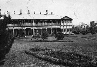
The Eton Vale Homestead Ruins are a heritage-listed site on the New England Highway, Cambooya, Toowoomba Region, Queensland, Australia. The former homestead was built from c. 1840 onwards by Arthur Hodgson, and was destroyed by fire in 1912. The site was added to the Queensland Heritage Register on 21 October 1992.

Southbrook, Queensland Town in Queensland, Australia

Southbrook is a rural town and locality in the Toowoomba Region, Queensland, Australia. In the 2016 census, Southbrook had a population of 599 people.

Robert Ramsay (Queensland politician) Scottish Australian politician

Robert Ramsay was a member of the Queensland Legislative Council, the Queensland Legislative Assembly, and the eighth Treasurer of Queensland.

Ramsay, Queensland Suburb of Toowoomba Region, Queensland, Australia

Ramsay is a rural locality in the Toowoomba Region, Queensland, Australia. In the 2016 census Ramsay had a population of 348 people.

Oman Ama, Queensland Suburb of Goondiwindi Region, Queensland, Australia

Oman Ama is a rural locality in the Goondiwindi Region, Queensland, Australia. In the 2016 census, Oman Ama had a population of 38 people.

Brookstead, Queensland Town in Queensland, Australia

Brookstead is a rural town and locality in the Toowoomba Region, Queensland, Australia. In the 2016 census, Brookstead had a population of 217 people.

Turallin, Queensland Town in Queensland, Australia

Turallin is a town and a locality in the Toowoomba Region, Queensland, Australia. In the 2016 census, Turallin had a population of 65 people.

References

  1. "Preston - Toowoomba Region (entry 48042)". Queensland Place Names. Queensland Government . Retrieved 31 May 2017.
  2. "Preston - Lockyer Valley Region (entry 47618)". Queensland Place Names. Queensland Government . Retrieved 31 May 2017.
  3. Queensland Family History Society (2010), Queensland schools past and present (Version 1.01 ed.), Queensland Family History Society, ISBN   978-1-921171-26-0
  4. "Toowoomba" (Map). Queensland Government. 1944. Archived from the original on 26 December 2020. Retrieved 23 September 2020.
  5. "Preston Peak Chapel, Wedding Venue Toowoomba,". Preston Chapel and Manor. Retrieved 23 September 2020.
  6. "Dedication Anniversary At Omanama". Warwick Daily News (9360). Queensland, Australia. 5 August 1949. p. 3. Archived from the original on 26 December 2020. Retrieved 23 September 2020 via National Library of Australia.
  7. "Closed Churches". Anglican Church of Southern Queensland. Archived from the original on 3 April 2019. Retrieved 24 February 2019.CS1 maint: unfit URL (link)
  8. "Branch Locations". Queensland Country Women's Association. Archived from the original on 26 December 2018. Retrieved 26 December 2018.

Further reading