Lefthand Branch, Queensland

Last updated

Lefthand Branch
Queensland
Australia Queensland location map.svg
Red pog.svg
Lefthand Branch
Coordinates 27°47′23″S152°15′45″E / 27.7897°S 152.2625°E / -27.7897; 152.2625 (Lefthand Branch (centre of locality))
Population69 (SAL 2021) [1]
Postcode(s) 4343
Elevation190–900 m (623–2,953 ft) [2]
Area65.8 km2 (25.4 sq mi)
Time zone AEST (UTC+10:00)
Location
LGA(s) Lockyer Valley Region
State electorate(s) Lockyer
Federal division(s) Wright
Suburbs around Lefthand Branch:
Mount Sylvia Ingoldsby Ingoldsby
Woodbine
Junction View
Lefthand Branch Thornton
East Haldon East Haldon Townson

Lefthand Branch is a rural locality in the Lockyer Valley Region, Queensland, Australia. [3] In the 2021 census, Lefthand Branch had a population of 69 people. [4]

Contents

Geography

Lefthand Branch is named for the creek, Lefthand Branch creek that runs the length of the valley and the creek is named for the fact that it turns left after splitting from Tent Hill Creek. The narrow valley runs south east for approximately 11 kilometers. It is mainly cattle properties and some small vegetable crop farms, although there are a few olive crops and a small turf farm.[ citation needed ]

Lefthand Branch has the following mountain features:

Main Range National Park extends into the south of the locality. [2]

History

Hillview Provisional School opened on 16 October 1899. On 1 January 1909, it became Hillview State School. In 1914, it was renamed Viewland State School. It closed in 1923, to reopen in 1924 as Left Hand Branch State School, which finally closed in 1967. [7] It was on the western side of Lefthand Branch Road, south of the junction with Reibstein Gully Road (approx 27°45′51″S152°14′58″E / 27.76419°S 152.24941°E / -27.76419; 152.24941 (Left Hand Branch State School (former)) ). [8]

Demographics

In the 2016 census, Lefthand Branch had a population of 79 people. [9]

In the 2021 census, Lefthand Branch had a population of 69 people. [4]

Education

There are no schools in Lefthand Branch. The nearest government primary school is Mount Sylvia State School in neighbouring Mount Sylvia to the north-west. The nearest government secondary school is Lockyer District State High School in Gatton to the north. [10]

Related Research Articles

<span class="mw-page-title-main">Laidley, Queensland</span> Town in Queensland, Australia

Laidley is a rural town and locality in the Lockyer Valley Region, Queensland, Australia. In the 2016 census, the locality of Laidley had a population of 3,808 people.

<span class="mw-page-title-main">Warrill View, Queensland</span> Town in Queensland, Australia

Warrill View is a rural town and locality in the Scenic Rim Region, Queensland, Australia. In the 2021 census, the locality of Warrill View had a population of 203 people.

<span class="mw-page-title-main">Blenheim, Queensland</span> Suburb of Lockyer Valley Region, Queensland, Australia

Blenheim is a rural locality in the Lockyer Valley Region, Queensland, Australia. In the 2016 census, Blenheim had a population of 291 people.

<span class="mw-page-title-main">Mount Gipps, Queensland</span> Suburb of Scenic Rim Region, Queensland, Australia

Mount Gipps is a rural locality in the Scenic Rim Region, Queensland, Australia. In the 2016 census, Mount Gipps had a population of 7 people.

<span class="mw-page-title-main">Oaky Creek, Queensland</span> Suburb of Scenic Rim Region, Queensland, Australia

Oaky Creek is a rural locality in the Scenic Rim Region, Queensland, Australia. In the 2016 census Oaky Creek had a population of 83 people.

<span class="mw-page-title-main">Lamington, Queensland</span> Suburb of Scenic Rim Region, Queensland, Australia

Lamington is a rural locality in the Scenic Rim Region, Queensland, Australia. In the 2016 census, Lamington had a population of 86 people.

<span class="mw-page-title-main">Glenore Grove, Queensland</span> Suburb of Lockyer Valley Region, Queensland, Australia

Glenore Grove is a rural locality in the Lockyer Valley Region, Queensland, Australia. In the 2016 census, Glenore Grove had a population of 883 people.

Thornton is a rural locality in the Lockyer Valley Region, Queensland, Australia. In the 2016 census, Thornton had a population of 201 people.

Glen Cairn is a rural locality in the Lockyer Valley Region, Queensland, Australia. In the 2016 census, Glen Cairn had a population of 113 people.

Upper Lockyer is a rural locality in the Lockyer Valley Region, Queensland, Australia. In the 2016 census, Upper Lockyer had a population of 538 people.

Mount Berryman is a rural locality in the Lockyer Valley Region, Queensland, Australia. In the 2016 census, Mount Berryman had a population of 109 people.

<span class="mw-page-title-main">Mulgowie, Queensland</span> Suburb of Lockyer Valley Region, Queensland, Australia

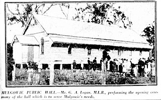
Mulgowie is a rural locality in the Lockyer Valley Region, Queensland, Australia. In the 2021 census, Mulgowie had a population of 166 people.

Rockmount is a rural locality in the Lockyer Valley Region, Queensland, Australia. In the 2016 census, Rockmount had a population of 87 people.

Townson is a rural locality in the Lockyer Valley Region, Queensland, Australia. In the 2016 census, Townson had a population of 38 people.

Black Duck Creek is a rural locality in the Lockyer Valley Region, Queensland, Australia. In the 2016 census, Black Duck Creek had a population of 21 people.

Laidley Creek West is a rural locality in the Lockyer Valley Region, Queensland, Australia. In the 2021 census, Laidley Creek West had a population of 143 people.

<span class="mw-page-title-main">Laidley Heights, Queensland</span> Suburb of Lockyer Valley Region, Queensland, Australia

Laidley Heights is a rural residential locality on the outskirts of the town of Laidley in the Lockyer Valley Region, Queensland, Australia. In the 2021 census, Laidley Heights had a population of 1,429 people.

<span class="mw-page-title-main">Laidley North, Queensland</span> Suburb of Lockyer Valley Region, Queensland, Australia

Laidley North is a rural locality in the Lockyer Valley Region, Queensland, Australia. In the 2021 census, Laidley North had a population of 593 people.

Laidley South is a rural locality in the Lockyer Valley Region, Queensland, Australia. In the 2021 census, Laidley South had a population of 293 people.

Silver Ridge is a locality in the Lockyer Valley Region, Queensland, Australia.

References

  1. Australian Bureau of Statistics (28 June 2022). "Lefthand Branch (Suburb and Locality)". Australian Census 2021 QuickStats. Retrieved 28 June 2022.  OOjs UI icon edit-ltr-progressive.svg
  2. 1 2 "Queensland Globe". State of Queensland . Retrieved 26 October 2023.
  3. "Lefthand Branch – locality in Lockyer Valley Region (entry 44971)". Queensland Place Names. Queensland Government . Retrieved 16 November 2019.
  4. 1 2 Australian Bureau of Statistics (28 June 2022). "Lefthand Branch (SAL)". 2021 Census QuickStats. Retrieved 28 February 2023. OOjs UI icon edit-ltr-progressive.svg
  5. 1 2 "Mountain peaks and capes - Queensland". Queensland Open Data. Queensland Government. 12 November 2020. Archived from the original on 25 November 2020. Retrieved 25 November 2020.
  6. "Rocky Peak – mountain in Lockyer Valley Region (entry 28858)". Queensland Place Names. Queensland Government . Retrieved 25 November 2020.
  7. Queensland Family History Society (2010), Queensland schools past and present (Version 1.01 ed.), Queensland Family History Society, ISBN   978-1-921171-26-0
  8. "Queensland Two Mile series sheet 2m41" (Map). Queensland Government. 1962. Archived from the original on 26 October 2023. Retrieved 26 October 2023.
  9. Australian Bureau of Statistics (27 June 2017). "Lefthand Branch (SSC)". 2016 Census QuickStats. Retrieved 20 October 2018. OOjs UI icon edit-ltr-progressive.svg
  10. "Layers: Locality; Schools and school catchments". Queensland Globe. Queensland Government. Archived from the original on 19 December 2017. Retrieved 26 October 2023.