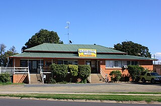
Grantham is a rural town and locality in the Lockyer Valley Region, Queensland, Australia. The town is located 100 kilometres (62 mi) west of the state capital, Brisbane. In the 2021 census, the locality of Grantham had a population of 796 people.
Clarendon is a rural locality in the Somerset Region, Queensland, Australia. In the 2021 census, Clarendon had a population of 232 people.

Murphys Creek is a rural town and locality in the Lockyer Valley Region, Queensland, Australia. In the 2021 census, the locality of Murphys Creek had a population of 633 people.

Withcott is a rural town and locality in the Lockyer Valley Region, Queensland, Australia. In the 2021 census, the locality of Withcott had a population of 2,067 people.

Ballard is a rural locality in the Lockyer Valley Region, Queensland, Australia. In the 2021 census, Ballard had a population of 167 people.

Lower Tenthill is a rural locality in the Lockyer Valley Region, Queensland, Australia. In the 2021 census, Lower Tenthill had a population of 236 people.

Postmans Ridge is a rural locality in the Lockyer Valley Region, Queensland, Australia. In the 2021 census, Postmans Ridge had a population of 352 people.
Glen Cairn is a rural locality in the Lockyer Valley Region, Queensland, Australia. In the 2021 census, Glen Cairn had a population of 141 people.
Buaraba is a rural locality in the Somerset Region, Queensland, Australia. In the 2021 census, Buaraba had a population of 170 people.

Caffey is a rural locality in the Lockyer Valley Region, Queensland, Australia. In the 2021 census, Caffey had a population of 45 people.
Carpendale is a rural locality in the Lockyer Valley Region, Queensland, Australia. In the 2021 census, Carpendale had a population of 110 people.
Derrymore is a rural locality in the Lockyer Valley Region, Queensland, Australia. In the 2021 census, Derrymore had a population of 85 people.
Iredale is a rural locality in the Lockyer Valley Region, Queensland, Australia. In the 2021 census, Iredale had a population of 177 people.
Upper Lockyer is a rural locality in the Lockyer Valley Region, Queensland, Australia. In the 2021 census, Upper Lockyer had a population of 542 people.

Mount Berryman is a rural locality in the Lockyer Valley Region, Queensland, Australia. In the 2021 census, Mount Berryman had a population of 96 people.
Rockmount is a rural locality in the Lockyer Valley Region, Queensland, Australia. In the 2021 census, Rockmount had a population of 82 people.

Brightview is a locality split between the Lockyer Valley Region and Somerset Region, Queensland, Australia. In the 2021 census, Brightview had a population of 911 people.
Helidon Spa is a rural locality in the Lockyer Valley Region, Queensland, Australia. In the 2021 census, Helidon Spa had a population of 504 people.
Laidley South is a rural locality in the Lockyer Valley Region, Queensland, Australia. In the 2021 census, Laidley South had a population of 293 people.
Seventeen Mile is a rural locality in the Lockyer Valley Region, Queensland, Australia. In the 2021 census, Seventeen Mile had a population of 22 people.


