Mount Sylvia, Queensland

Last updated

Map all coordinates using: OpenStreetMap  
Download coordinates as: KML
Mount Sylvia
Queensland
Queensland State Archives 2494 Repsteines orchard at Mount Sylvia Gatton c 1898.png
Orchard at Mount Sylvia, circa 1898
Australia Queensland location map.svg
Red pog.svg
Mount Sylvia
Coordinates 27°44′17″S152°13′35″E / 27.7380°S 152.2263°E / -27.7380; 152.2263 (Mount Sylvia (centre of locality)) Coordinates: 27°44′17″S152°13′35″E / 27.7380°S 152.2263°E / -27.7380; 152.2263 (Mount Sylvia (centre of locality))
Population106 (2016 census) [1]
 • Density2.579/km2 (6.68/sq mi)
Postcode(s) 4343
Area41.1 km2 (15.9 sq mi)
Time zone AEST (UTC+10:00)
LGA(s) Lockyer Valley Region
State electorate(s) Lockyer
Federal division(s) Wright
Suburbs around Mount Sylvia:
Mount Whitestone Caffey Ingoldsby
Mount Whitestone Mount Sylvia Lefthand Branch
West Haldon Woodbine Lefthand Branch

Mount Sylvia is a rural locality in the Lockyer Valley Region, Queensland, Australia. [2] In the 2016 census, Mount Sylvia had a population of 106 people. [1]

Contents

History

Mount Sylvia Provisional School opened on 13 April 1885, becoming Mount Sylvia State School on 1 January 1909. [3]

St Patrick's Catholic Church opened in 1897. It has subsequently closed. It was at 1304 Mount Sylvia Road. [4]

Cross Lutheran Church opened on Sunday 26 March 1905. [5]

Mount Sylvia Congregational Church opened in 1909. In 1977 when the Uniting Church in Australia was established through amalgamation of the Methodist, Presbyterian and Congregational Churches, it became Mount Sylvia Uniting Church. It was at 387 Back Mount Sylvia Road ( 27°43′17″S152°13′10″E / 27.7214°S 152.2195°E / -27.7214; 152.2195 (St Patrick's Catholic Church (former)) ). It has closed and was sold on 17 February 2022 for $89,000. [6] [7] [8]

In the 2016 census, Mount Sylvia had a population of 106 people. [1]

Education

Mount Sylvia State School is a government primary (Prep-6) school for boys and girls at 6 Left Hand Branch Road ( 27°43′23″S152°13′26″E / 27.7230°S 152.2240°E / -27.7230; 152.2240 (Mount Sylvia State School) ). [9] [10] In 2016, the school had an enrolment of 46 students with 4 teachers (2 full-time equivalent) and 4 non-teaching staff (2 full-time equivalent). [11] In 2018, the school had an enrolment of 26 students with 4 teachers (2 full-time equivalent) and 4 non-teaching staff (2 full-time equivalent). [12]

Amenities

Cross Lutheran Church is at 143 Left Hand Branch Road ( 27°43′55″S152°13′57″E / 27.7320°S 152.2324°E / -27.7320; 152.2324 (Cross Lutheran Church) ). [13]

Related Research Articles

Esk, Queensland Town in Queensland, Australia

Esk is a town and locality in the Somerset Region in South East Queensland, Australia. In the 2016 census, Esk had a population of 1,698 people.

Gatton, Queensland Town in Queensland, Australia

Gatton is a rural town and locality in the Lockyer Valley Region, Queensland, Australia. In the 2016 census, the locality of Gatton had a population of 7,101 people.

Laidley, Queensland Town in Queensland, Australia

Laidley is a rural town and locality in the Lockyer Valley Region, Queensland, Australia. In the 2016 census, the locality of Laidley had a population of 3,808 people.

Middle Park, Queensland Suburb of Brisbane, Queensland, Australia

Middle Park is a residential south-western suburb in the Centenary Suburbs in the City of Brisbane, Queensland, Australia. In the 2016 census, Middle Park had a population of 3,955 people.

Rosewood, Queensland Town in Queensland, Australia

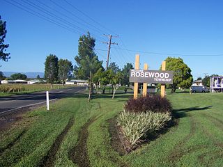
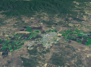
Rosewood is a rural town and locality in the City of Ipswich, Queensland, Australia. In the 2016 census, the locality of Rosewood had a population of 2,834 people.

Minden, Queensland Town in Queensland, Australia

Minden is a rural town and locality in the Somerset Region, Queensland, Australia. In the 2016 census, the locality of Minden had a population of 1,204 people.

Brassall, Queensland Suburb of Ipswich, Queensland, Australia

Brassall is a suburb in the City of Ipswich, Queensland, Australia. In the 2016 census, Brassall had a population of 10,898 people.

Haigslea, Queensland Suburb of Ipswich, Queensland, Australia

Haigslea is a locality split between the City of Ipswich and the Somerset Region in South East Queensland, Australia. In the 2016 census, Haigslea had a population of 468 people.

Plainland Suburb of Lockyer Valley Region, Queensland, Australia

Plainland is a rural locality in the Lockyer Valley Region, Queensland, Australia. In the 2016 census, Plainland had a population of 1,596 people.

Hatton Vale Suburb of Lockyer Valley Region, Queensland, Australia

Hatton Vale is a rural locality in the Lockyer Valley Region, Queensland, Australia. In the 2016 census, Hatton Vale had a population of 1,521 people.

Blanchview is a rural locality in the Lockyer Valley Region, Queensland, Australia. In the 2016 census, Blanchview had a population of 191 people.

Lockrose Suburb of Lockyer Valley Region, Queensland, Australia

Lockrose is a rural locality split between the Lockyer Valley Region and Somerset Region of Queensland, Australia. In the 2016 census, Lockrose had a population of 562 people.

Blenheim is a rural locality in the Lockyer Valley Region, Queensland, Australia. In the 2016 census, Blenheim had a population of 291 people.

Flagstone Creek is a rural locality in the Lockyer Valley Region, Queensland, Australia. In the 2016 census, Flagstone Creek had a population of 220 people.

Mount Whitestone, Queensland Suburb of Lockyer Valley Region, Queensland, Australia

Mount Whitestone is a rural locality in the Lockyer Valley Region, Queensland, Australia. In the 2016 census, Mount Whitestone had a population of 154 people.

Ropeley, Queensland Suburb of Lockyer Valley Region, Queensland, Australia

Ropeley is a rural locality in the Lockyer Valley Region, Queensland, Australia. In the 2016 census Ropeley had a population of 194 people.

Caffey, Queensland Suburb of Lockyer Valley Region, Queensland, Australia

Caffey is a rural locality in the Lockyer Valley Region, Queensland, Australia. In the 2016 census, Caffey had a population of 65 people.

Mount Berryman is a rural locality in the Lockyer Valley Region, Queensland, Australia. In the 2016 census, Mount Berryman had a population of 109 people.

Upper Tenthill, Queensland Suburb of Lockyer Valley Region, Queensland, Australia

Upper Tenthill is a rural locality in the Lockyer Valley Region, Queensland, Australia. In the 2016 census, Upper Tenthill had a population of 234 people.

Black Duck Creek is a rural locality in the Lockyer Valley Region, Queensland, Australia. In the 2016 census, Black Duck Creek had a population of 21 people.

References

  1. 1 2 3 Australian Bureau of Statistics (27 June 2017). "Mount Sylvia (SSC)". 2016 Census QuickStats. Retrieved 20 October 2018. OOjs UI icon edit-ltr-progressive.svg
  2. "Mount Sylvia – locality in Lockyer Valley Region (entry 44980)". Queensland Place Names. Queensland Government . Retrieved 27 December 2020.
  3. Queensland Family History Society (2010), Queensland schools past and present (Version 1.01 ed.), Queensland Family History Society, ISBN   978-1-921171-26-0
  4. "St Patrick's Catholic Church - Former". Churches Australia. Retrieved 25 July 2022.
  5. "BELOW THE RANGE". The Brisbane Courier . Vol. LXI, no. 14, 730. Queensland, Australia. 29 March 1905. p. 6. Retrieved 25 July 2022 via National Library of Australia.
  6. Blake, Thom. "Mount Sylvia Congregational Church". Queensland religious places database. Retrieved 25 July 2022.
  7. "Mt Sylvia Uniting Church - Former". Churches Australia. Retrieved 25 July 2022.
  8. "387 Back Mount Sylvia Road, Mount Sylvia, Qld 4343". Realestate.com.au . Retrieved 25 July 2022.
  9. "State and non-state school details". Queensland Government. 9 July 2018. Archived from the original on 21 November 2018. Retrieved 21 November 2018.
  10. "Mount Sylvia State School" . Retrieved 21 November 2018.
  11. "Annual Report 2016" (PDF). Mount Sylvia State School. Archived (PDF) from the original on 12 September 2017. Retrieved 12 September 2017.
  12. "ACARA School Profile 2018". Australian Curriculum, Assessment and Reporting Authority . Retrieved 28 January 2020.
  13. Blake, Thom. "Cross Lutheran Church". Queensland religious places database. Retrieved 25 July 2022.

Further reading

Commons-logo.svg Media related to Mount Sylvia, Queensland at Wikimedia Commons