Laidley North, Queensland

Last updated

Map all coordinates using: OpenStreetMap
Laidley North
Queensland
Teachers and pupils outside Laidley North State School and residence, circa 1889.jpg
Teachers and pupils outside Laidley North State School and residence, circa 1889
Australia Queensland location map.svg
Red pog.svg
Laidley North
Coordinates 27°36′44″S152°24′27″E / 27.6122°S 152.4075°E / -27.6122; 152.4075 (Laidley North (centre of locality))
Population593 (SAL 2021) [1]
Postcode(s) 4341
Area15.3 km2 (5.9 sq mi)
Time zone AEST (UTC+10:00)
Location
LGA(s) Lockyer Valley Region
State electorate(s) Lockyer
Federal division(s) Wright
Suburbs around Laidley North:
Forest Hill Plainland Summerholm
Forest Hill Laidley North Summerholm
Laidley Heights Laidley Laidley

Laidley North is a rural locality in the Lockyer Valley Region, Queensland, Australia. [2] In the 2021 census, Laidley North had a population of 593 people. [3]

Contents

Geography

As the name suggests, Laidley North is immediately north of the town of Laidley. [4]

The locality is bounded to the south-west by Laidley Creek. [4]

The land use is mixed. Being close to Laidley, there is some rural residential housing and some suburban housing. Land near the Laidley Creek is used for irrigated horticulture. Apart from these, the predominant land use is grazing on native vegetation. [4]

Laidley–Plainland Road runs through from south to north. [5]

History

The locality's name is derived from the town name of Laidley, which derives from the naming of Laidleys Plain by explorer Allan Cunningham after James Laidley, the New South Wales Deputy Commissary General. [2]

Laidley North Mixed State School opened on 1 April 1889. In 1897, the name was changed to Laidley North State School. A secondary department operated from 1964 to 1984 (after which a separate Laidley State High School opened in 1985 on another site). Laidley North State School closed on 12 December 1998, [6] but Laidley District State School (an amalgamation of Laidley North State School and Laidley Central State School) opened on the Laidley North State School site in 1999. [7] The school site is now within the boundaries of Laidley at 218-220 Patrick Street ( 27°37′27″S152°23′44″E / 27.6243°S 152.3955°E / -27.6243; 152.3955 (Laidley North State School (former)) ). [8] [4]

Demographics

In the 2016 census, Laidley North had a population of 408 people. [9]

In the 2021 census, Laidley North had a population of 593 people. [3]

Education

There are no schools in Laidley North. The nearest government primary schools are Laidley District State School in neighbouring Laidley to the south and Forest Hill State School in neighbouring Forest Hill to the west. The nearest governent secondary school is Laidley State High School in Laidley to the south. [10]

Amenities

Laidley Cultural Centre is at 3 Laidley Plainland Road ( 27°36′48″S152°23′51″E / 27.6133°S 152.3975°E / -27.6133; 152.3975 (Laidley Cultural Centre) ). It is operated by the Lockyer Valley Regional Council. [11]

The Laidley District Cricket Club plays at the Bichel Oval on the Laidley Plainland Road ( 27°36′51″S152°23′50″E / 27.6141°S 152.3971°E / -27.6141; 152.3971 (Bichel Oval) ). [4] [12]

Facilities

In the north of the locality is the 184-hectare (450-acre) Darbalara Farm operated by the University of Queensland's Gatton campus ( 27°35′43″S152°23′07″E / 27.5953°S 152.3854°E / -27.5953; 152.3854 (Darbalara Farm (UQ)) ).The university's School of Veterinary Science uses the farm to maintains a Droughtmaster herd and other beef cattle as part of its teaching and research programs. [13]

The Laidley Sewerage Treatment Plant is in Brahman Road ( 27°36′39″S152°24′23″E / 27.6109°S 152.4065°E / -27.6109; 152.4065 (Laidley Sewerage Treatment Plant) ). It is operated by Queensland Urban Utilities. [14]

Related Research Articles

<span class="mw-page-title-main">Laidley, Queensland</span> Town in Queensland, Australia

Laidley is a rural town and locality in the Lockyer Valley Region, Queensland, Australia. In the 2016 census, the locality of Laidley had a population of 3,808 people.

<span class="mw-page-title-main">Shire of Gatton</span> Local government area in Queensland, Australia

The Shire of Gatton was a local government area located in the Lockyer Valley region between the cities of Toowoomba and Ipswich, and about 90 kilometres (56 mi) west of Brisbane, the state capital of Queensland, Australia. The shire covered an area of 1,571.8 square kilometres (606.9 sq mi), and existed from 1880 until its merger with the Shire of Laidley to form the Lockyer Valley Region on 15 March 2008.

<span class="mw-page-title-main">Shire of Laidley</span> Local government area in Queensland, Australia

The Shire of Laidley was a local government area located in the Lockyer Valley region between the cities of Toowoomba and Ipswich, and about 70 kilometres (43 mi) west of Brisbane, the state capital of Queensland, Australia. The shire covered an area of 700.6 square kilometres (270.5 sq mi), and existed from 1888 until its merger with the Shire of Gatton to form the Lockyer Valley Region on 15 March 2008.

<span class="mw-page-title-main">Lockyer Valley Region</span> Local government area in Queensland, Australia

The Lockyer Valley Region is a local government area in the West Moreton region of South East Queensland, Australia, between the cities of Ipswich and Toowoomba. It was created in 2008 from a merger of the Shire of Gatton and the Shire of Laidley. It has an estimated operating budget of A$35m.

<span class="mw-page-title-main">Forest Hill, Queensland</span> Town in Queensland, Australia

Forest Hill is a rural town and locality in the Lockyer Valley Region, Queensland, Australia. In the 2016 census, Forest Hill had a population of 968 people.

<span class="mw-page-title-main">Plainland</span> Suburb of Lockyer Valley Region, Queensland, Australia

Plainland is a rural locality and development centre in the Lockyer Valley Region, Queensland, Australia. In the 2021 census, Plainland had a population of 1,930 people - an increase of 21% from the 2016 census.

<span class="mw-page-title-main">Blenheim, Queensland</span> Suburb of Lockyer Valley Region, Queensland, Australia

Blenheim is a rural locality in the Lockyer Valley Region, Queensland, Australia. In the 2016 census, Blenheim had a population of 291 people.

Lefthand Branch is a rural locality in the Lockyer Valley Region, Queensland, Australia. In the 2021 census, Lefthand Branch had a population of 69 people.

Adare is a rural locality in the Lockyer Valley Region, Queensland, Australia. In the 2016 census, Adare had a population of 873 people.

<span class="mw-page-title-main">Glenore Grove, Queensland</span> Suburb of Lockyer Valley Region, Queensland, Australia

Glenore Grove is a rural locality in the Lockyer Valley Region, Queensland, Australia. In the 2016 census, Glenore Grove had a population of 883 people.

Thornton is a rural locality in the Lockyer Valley Region, Queensland, Australia. In the 2016 census, Thornton had a population of 201 people.

Glen Cairn is a rural locality in the Lockyer Valley Region, Queensland, Australia. In the 2016 census, Glen Cairn had a population of 113 people.

Mount Berryman is a rural locality in the Lockyer Valley Region, Queensland, Australia. In the 2016 census, Mount Berryman had a population of 109 people.

<span class="mw-page-title-main">Mulgowie, Queensland</span> Suburb of Lockyer Valley Region, Queensland, Australia

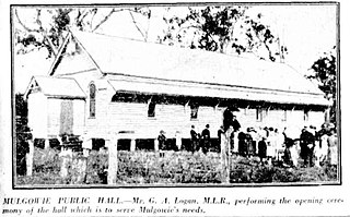
Mulgowie is a rural locality in the Lockyer Valley Region, Queensland, Australia. In the 2021 census, Mulgowie had a population of 166 people.

Summerholm is a rural locality in the Lockyer Valley Region, Queensland, Australia. In the 2021 census, Summerholm had a population of 646 people.

Townson is a rural locality in the Lockyer Valley Region, Queensland, Australia. In the 2016 census, Townson had a population of 38 people.

Laidley Creek West is a rural locality in the Lockyer Valley Region, Queensland, Australia. In the 2021 census, Laidley Creek West had a population of 143 people.

<span class="mw-page-title-main">Laidley Heights, Queensland</span> Suburb of Lockyer Valley Region, Queensland, Australia

Laidley Heights is a rural residential locality on the outskirts of the town of Laidley in the Lockyer Valley Region, Queensland, Australia. In the 2021 census, Laidley Heights had a population of 1,429 people.

Laidley South is a rural locality in the Lockyer Valley Region, Queensland, Australia. In the 2021 census, Laidley South had a population of 293 people.

Regency Downs is a mixed-use locality in the Lockyer Valley Region, Queensland, Australia. In the 2021 census, Regency Downs had a population of 2,623 people, an increase of 12% from the 2016 census.

References

  1. Australian Bureau of Statistics (28 June 2022). "Laidley North (suburb and locality)". Australian Census 2021 QuickStats. Retrieved 28 June 2022.  OOjs UI icon edit-ltr-progressive.svg
  2. 1 2 "Laidley North – locality in Lockyer Valley Region (entry 44967)". Queensland Place Names. Queensland Government . Retrieved 12 November 2018.
  3. 1 2 Australian Bureau of Statistics (28 June 2022). "Laidley North (SAL)". 2021 Census QuickStats. Retrieved 28 February 2023. OOjs UI icon edit-ltr-progressive.svg
  4. 1 2 3 4 5 "Queensland Globe". State of Queensland . Retrieved 7 October 2023.
  5. Google (7 January 2024). "Laidley North, Queensland" (Map). Google Maps . Google. Retrieved 7 January 2024.
  6. "Queensland state school - centre closures" (PDF). Queensland Government . 20 August 2013. Archived (PDF) from the original on 20 March 2022. Retrieved 7 April 2022.
  7. Queensland Family History Society (2010), Queensland schools past and present (Version 1.01 ed.), Queensland Family History Society, ISBN   978-1-921171-26-0
  8. "Town of Laidley" (Map). Queensland Government. 1978. Archived from the original on 30 April 2022. Retrieved 30 April 2022.
  9. Australian Bureau of Statistics (27 June 2017). "Laidley North (SSC)". 2016 Census QuickStats. Retrieved 20 October 2018. OOjs UI icon edit-ltr-progressive.svg
  10. "Layers: Locality; Schools and school catchments". Queensland Globe. Queensland Government. Archived from the original on 19 December 2017. Retrieved 6 October 2023.
  11. "Laidley Cultural Centre". Lockyer Valley Regional Council . Archived from the original on 1 June 2023. Retrieved 7 October 2023.
  12. "Laidley District Cricket Club". Facebook. Retrieved 7 October 2023.
  13. "Gatton Farms". Gatton campus, University of Queensland . Archived from the original on 24 May 2023. Retrieved 7 October 2023.
  14. "Laidley Sewage Treatment Works". Wetland Info. Queensland Government. Archived from the original on 27 March 2023. Retrieved 7 October 2023.

Further reading