Glen Cairn, Queensland

Last updated

Glen Cairn
Queensland
Australia Queensland location map.svg
Red pog.svg
Glen Cairn
Coordinates 27°36′53″S152°19′48″E / 27.6147°S 152.3300°E / -27.6147; 152.3300 (Glen Cairn (centre of locality))
Population141 (2021 census) [1]
 • Density9.46/km2 (24.51/sq mi)
Postcode(s) 4342
Area14.9 km2 (5.8 sq mi)
Time zone AEST (UTC+10:00)
Location
LGA(s) Lockyer Valley Region
State electorate(s) Lockyer
Federal division(s) Wright
Suburbs around Glen Cairn:
Gatton Lawes Forest Hill
Woodlands Glen Cairn Laidley Heights
Blenheim Blenheim Blenheim

Glen Cairn is a rural locality in the Lockyer Valley Region, Queensland, Australia. [2] In the 2021 census, Glen Cairn had a population of 141 people. [1]

Contents

Geography

The eastern part of the locality is lower flatter land mostly cleared for irrigated seasonal horticulture. The western part of the locality is hillier and has more natural bushland; it is predominantly used for grazing on native vegetation. [3]

History

The Ropeley East State school building was relocated to Glen Cairn in early 1926. [4] Glen Cairn State School opened on 4 October 1926. It closed on 1972. [5] It was on Glen Cairn Road (approx 27°36′53″S152°20′22″E / 27.6146°S 152.3394°E / -27.6146; 152.3394 (Glen Cairn State School (former)) ). [6] [7] [3]

Demographics

In the 2016 census, Glen Cairn had a population of 113 people. [8]

In the 2021 census, Glen Cairn had a population of 141 people. [1]

Education

There are no schools in Glen Cairn. The nearest government primary schools are Forest Hill State School in neighbouring Forest Hill to the north-east, Blenheim State School in neighbouring Blenheim to the south, and Gatton State School in neighbouring Gatton to the north-west. The nearest government secondary schools are Laidley State High School in Laidley to the east and Lockyer District State High School in Gatton to the north-west. [3]

Related Research Articles

<span class="mw-page-title-main">Laidley, Queensland</span> Town in Queensland, Australia

Laidley is a rural town and locality in the Lockyer Valley Region, Queensland, Australia. In the 2016 census, the locality of Laidley had a population of 3,808 people.

<span class="mw-page-title-main">Blenheim, Queensland</span> Suburb of Lockyer Valley Region, Queensland, Australia

Blenheim is a rural locality in the Lockyer Valley Region, Queensland, Australia. In the 2021 census, Blenheim had a population of 264 people.

<span class="mw-page-title-main">West Haldon, Queensland</span> Suburb of Toowoomba Region, Queensland, Australia

West Haldon is a locality split between Toowoomba Region and Lockyer Valley Region in Queensland, Australia. In the 2021 census, West Haldon had a population of 63 people.

Lefthand Branch is a rural locality in the Lockyer Valley Region, Queensland, Australia. In the 2021 census, Lefthand Branch had a population of 69 people.

Adare is a rural locality in the Lockyer Valley Region, Queensland, Australia. In the 2021 census, Adare had a population of 1,027 people.

<span class="mw-page-title-main">Glenore Grove, Queensland</span> Suburb of Lockyer Valley Region, Queensland, Australia

Glenore Grove is a rural locality in the Lockyer Valley Region, Queensland, Australia. In the 2021 census, Glenore Grove had a population of 953 people.

<span class="mw-page-title-main">Caffey, Queensland</span> Suburb of Lockyer Valley Region, Queensland, Australia

Caffey is a rural locality in the Lockyer Valley Region, Queensland, Australia. In the 2021 census, Caffey had a population of 45 people.

<span class="mw-page-title-main">Mount Berryman, Queensland</span> Suburb of Lockyer Valley Region, Queensland, Australia

Mount Berryman is a rural locality in the Lockyer Valley Region, Queensland, Australia. In the 2021 census, Mount Berryman had a population of 96 people.

<span class="mw-page-title-main">Mulgowie, Queensland</span> Suburb of Lockyer Valley Region, Queensland, Australia

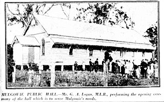
Mulgowie is a rural locality in the Lockyer Valley Region, Queensland, Australia. In the 2021 census, Mulgowie had a population of 166 people.

Summerholm is a rural locality in the Lockyer Valley Region, Queensland, Australia. In the 2021 census, Summerholm had a population of 646 people.

Townson is a rural locality in the Lockyer Valley Region, Queensland, Australia. In the 2016 census, Townson had a population of 38 people.

Laidley Creek West is a rural locality in the Lockyer Valley Region, Queensland, Australia. In the 2021 census, Laidley Creek West had a population of 143 people.

<span class="mw-page-title-main">Laidley Heights, Queensland</span> Suburb of Lockyer Valley Region, Queensland, Australia

Laidley Heights is a rural residential locality on the outskirts of the town of Laidley in the Lockyer Valley Region, Queensland, Australia. In the 2021 census, Laidley Heights had a population of 1,429 people.

<span class="mw-page-title-main">Laidley North, Queensland</span> Suburb of Lockyer Valley Region, Queensland, Australia

Laidley North is a rural locality in the Lockyer Valley Region, Queensland, Australia. In the 2021 census, Laidley North had a population of 593 people.

Laidley South is a rural locality in the Lockyer Valley Region, Queensland, Australia. In the 2021 census, Laidley South had a population of 293 people.

<span class="mw-page-title-main">Lockyer Waters, Queensland</span> Suburb of Lockyer Valley Region, Queensland, Australia

Lockyer Waters is a rural locality in the Lockyer Valley Region, Queensland, Australia. In the 2021 census, Lockyer Waters had a population of 538 people.

Placid Hills is a mixed-use locality on the western outskirts of the town of Gatton in the Lockyer Valley Region, Queensland, Australia. In the 2021 census, Placid Hills had a population of 796 people.

Regency Downs is a mixed-use locality in the Lockyer Valley Region, Queensland, Australia. In the 2021 census, Regency Downs had a population of 2,623 people, an increase of 12% from the 2016 census.

Seventeen Mile is a rural locality in the Lockyer Valley Region, Queensland, Australia. In the 2021 census, Seventeen Mile had a population of 22 people.

Veradilla is a rural locality in the Lockyer Valley Region, Queensland, Australia. In the 2021 census, Veradilla had a population of 125 people.

References

  1. 1 2 3 Australian Bureau of Statistics (28 June 2022). "Glen Cairn (SAL)". 2021 Census QuickStats. Retrieved 28 February 2023. OOjs UI icon edit-ltr-progressive.svg
  2. "Glen Cairn – locality in Lockyer Valley Region (entry 44955)". Queensland Place Names. Queensland Government . Retrieved 18 September 2020.
  3. 1 2 3 "Queensland Globe". State of Queensland . Retrieved 7 June 2022.
  4. "STATE SCHOOL IMPROVEMENT". Queensland Times . Vol. LXVI, no. 12, 340. Queensland, Australia. 1 February 1926. p. 4 (DAILY). Archived from the original on 7 June 2022. Retrieved 6 June 2022 via National Library of Australia.
  5. Queensland Family History Society (2010), Queensland schools past and present (Version 1.01 ed.), Queensland Family History Society, ISBN   978-1-921171-26-0
  6. "Helidon" (Map). Queensland Government. 1936. Archived from the original on 1 July 2020. Retrieved 7 June 2022.
  7. "Queensland Two Mile series sheet 2m43" (Map). Queensland Government. 1953. Archived from the original on 13 August 2021. Retrieved 7 June 2022.
  8. Australian Bureau of Statistics (27 June 2017). "Glen Cairn (SSC)". 2016 Census QuickStats. Retrieved 20 October 2018. OOjs UI icon edit-ltr-progressive.svg