Summerholm, Queensland

Last updated

Summerholm
Queensland
Australia Queensland location map.svg
Red pog.svg
Summerholm
Coordinates 27°36′36″S152°27′35″E / 27.61°S 152.4597°E / -27.61; 152.4597 (Summerholm (centre of locality))
Population646 (SAL 2021) [1]
Postcode(s) 4341
Area39.8 km2 (15.4 sq mi)
Time zone AEST (UTC+10:00)
Location
LGA(s) Lockyer Valley Region
State electorate(s) Lockyer
Federal division(s) Wright
Suburbs around Summerholm:
Plainland Hatton Vale Hatton Vale
Laidley North Summerholm Woolshed
Laidley Grandchester Grandchester

Summerholm is a rural locality in the Lockyer Valley Region, Queensland, Australia. [2] In the 2021 census, Summerholm had a population of 646 people. [3]

Contents

Geography

The locality is bounded to the north by Woolshed Creek Road and to the south-east by Long Gully Road which loosely follows the course of Woolshed Creek. The locality's southern boundary is formed by the Main Line railway, but there are no railway stations serving the locality. [4]

The terrain varies from 90 to 340 metres (300 to 1,120 ft) above sea level. [4] There are no named peaks in the locality, apart from Lady Bowen Hill at the western end of Stokes Road ( 27°39′42″S152°27′24″E / 27.6616°S 152.4566°E / -27.6616; 152.4566 (Lady Bowen Hill) ) at 110 to 120 metres (360 to 390 ft). [5]

The land use is a mixture of grazing on native vegetation and rural residential housing. [4]

History

Queensland's first section of railway was the Main Line railway from the original Ipswich railway station to Grandchester railway station. It was officially opened in July 1865 by the Governor of Queensland, George Bowen. As part of the opening ceremonies, there was a celebratory function held on a nearby hill (now within Summerholm) where the Governor's wife Lady Bowen planted a tree, leading to its name Lady Bowen Hill. [6] [5] [7]

Summer Hill Provisional School opened on 2 September 1889 with 13 students under teacher Miss M. Hanley. [8] On 1 January 1909, it became Summer Hill State School. It was on a 10-acre (4.0 ha) site at 61 Summerholm Road ( 27°37′05″S152°26′59″E / 27.61797°S 152.44964°E / -27.61797; 152.44964 (Summerholm State School (former)) ). [9] [10] In 1911, the school committee wanted to have the school relocated to a more central localition as the population of the district had moved further to the north. [11] In 1937, a new school building was erected in a "central location" and officially opened on Saturday 17 April 1937 by Ted Maher, the Member of the Queensland Legislative Assembly for West Moreton. [12] [13] In 1944, it was renamed Summerholm State School. It closed circa 1955. [14] It was at 51 Summerholm Road ( 27°36′30″S152°27′01″E / 27.60842°S 152.45015°E / -27.60842; 152.45015 (Summerholm State School (former)) ), approximately 1 kilometre (0.62 mi) north of the school's previous location. [15] [4] As at July 2023, the school building is still extant, but has been converted into a house. [16] [17]

Demographics

In the 2016 census, Summerholm had a population of 639 people. [18]

In the 2021 census, Summerholm had a population of 646 people. [3]

Education

There are no schools in Summerholm. The nearest government primary schools are Hatton Vale State School in neighbouring Hatton Vale to the north, Grandchester State School in neighbouring Grandchester to the south and Laidley District State School in neighbouring Laidley to the south-west. The nearest government secondary schools are Laidley State High School in neighbouring Laidley to the south-west and Rosewood State High School in Rosewood to the south-east. [19]

Related Research Articles

<span class="mw-page-title-main">Mount Pleasant, Queensland (Moreton Bay)</span> Suburb of City of Moreton Bay, Queensland, Australia

Mount Pleasant is a rural locality in the City of Moreton Bay, Queensland, Australia. In the 2016 census, Mount Pleasant had a population of 332 people.

<span class="mw-page-title-main">Laidley, Queensland</span> Town in Queensland, Australia

Laidley is a rural town and locality in the Lockyer Valley Region, Queensland, Australia. In the 2016 census, the locality of Laidley had a population of 3,808 people.

<span class="mw-page-title-main">Tallegalla, Queensland</span> Suburb of City of Ipswich, Queensland, Australia

Tallegalla is a rural locality in the City of Ipswich, Queensland, Australia. In the 2016 census, Tallegalla had a population of 326 people.

<span class="mw-page-title-main">Forest Hill, Queensland</span> Town in Queensland, Australia

Forest Hill is a rural town and locality in the Lockyer Valley Region, Queensland, Australia. In the 2016 census, Forest Hill had a population of 968 people.

<span class="mw-page-title-main">Plainland</span> Suburb of Lockyer Valley Region, Queensland, Australia

Plainland is a rural locality and development centre in the Lockyer Valley Region, Queensland, Australia. In the 2021 census, Plainland had a population of 1,930 people - an increase of 21% from the 2016 census.

Laceys Creek is a rural locality in the City of Moreton Bay, Queensland, Australia. In the 2016 census, Laceys Creek had a population of 278 people.

<span class="mw-page-title-main">Moodlu, Queensland</span> Suburb of City of Moreton Bay, Queensland, Australia

Moodlu is a rural locality in the City of Moreton Bay, Queensland, Australia. In the 2016 census, Moodlu had a population of 318 people.

<span class="mw-page-title-main">Blenheim, Queensland</span> Suburb of Lockyer Valley Region, Queensland, Australia

Blenheim is a rural locality in the Lockyer Valley Region, Queensland, Australia. In the 2016 census, Blenheim had a population of 291 people.

<span class="mw-page-title-main">Mount Mort, Queensland</span> Suburb of Ipswich, Queensland, Australia

Mount Mort is a rural locality in the City of Ipswich, Queensland, Australia. In the 2021 census, Mount Mort had a population of 78 people.

Lefthand Branch is a rural locality in the Lockyer Valley Region, Queensland, Australia. In the 2021 census, Lefthand Branch had a population of 69 people.

<span class="mw-page-title-main">Glenore Grove, Queensland</span> Suburb of Lockyer Valley Region, Queensland, Australia

Glenore Grove is a rural locality in the Lockyer Valley Region, Queensland, Australia. In the 2016 census, Glenore Grove had a population of 883 people.

Glen Cairn is a rural locality in the Lockyer Valley Region, Queensland, Australia. In the 2016 census, Glen Cairn had a population of 113 people.

Mount Berryman is a rural locality in the Lockyer Valley Region, Queensland, Australia. In the 2016 census, Mount Berryman had a population of 109 people.

<span class="mw-page-title-main">Mulgowie, Queensland</span> Suburb of Lockyer Valley Region, Queensland, Australia

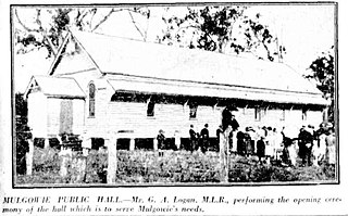
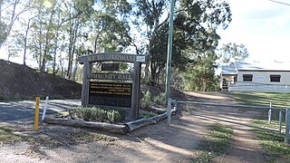
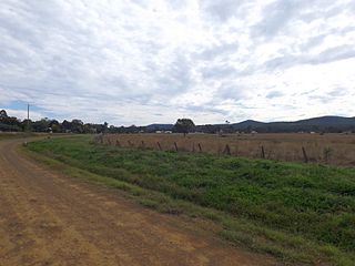
Mulgowie is a rural locality in the Lockyer Valley Region, Queensland, Australia. In the 2021 census, Mulgowie had a population of 166 people.

Townson is a rural locality in the Lockyer Valley Region, Queensland, Australia. In the 2016 census, Townson had a population of 38 people.

Laidley Creek West is a rural locality in the Lockyer Valley Region, Queensland, Australia. In the 2021 census, Laidley Creek West had a population of 143 people.

<span class="mw-page-title-main">Laidley Heights, Queensland</span> Suburb of Lockyer Valley Region, Queensland, Australia

Laidley Heights is a rural residential locality on the outskirts of the town of Laidley in the Lockyer Valley Region, Queensland, Australia. In the 2021 census, Laidley Heights had a population of 1,429 people.

<span class="mw-page-title-main">Laidley North, Queensland</span> Suburb of Lockyer Valley Region, Queensland, Australia

Laidley North is a rural locality in the Lockyer Valley Region, Queensland, Australia. In the 2021 census, Laidley North had a population of 593 people.

Laidley South is a rural locality in the Lockyer Valley Region, Queensland, Australia. In the 2021 census, Laidley South had a population of 293 people.

Seventeen Mile is a rural locality in the Lockyer Valley Region, Queensland, Australia. In the 2021 census, Seventeen Mile had a population of 22 people.

References

  1. Australian Bureau of Statistics (28 June 2022). "Summerholm (suburb and locality)". Australian Census 2021 QuickStats. Retrieved 28 June 2022.  OOjs UI icon edit-ltr-progressive.svg
  2. "Summerholm – locality in Lockyer Valley Region (entry 50040)". Queensland Place Names. Queensland Government . Retrieved 27 December 2020.
  3. 1 2 Australian Bureau of Statistics (28 June 2022). "Summerholm (SAL)". 2021 Census QuickStats. Retrieved 28 February 2023. OOjs UI icon edit-ltr-progressive.svg
  4. 1 2 3 4 "Queensland Globe". State of Queensland . Retrieved 9 January 2024.
  5. 1 2 "Lady Bowen Hill – hill in Lockyer Valley Regional (entry 47637)". Queensland Place Names. Queensland Government . Retrieved 9 January 2024.
  6. "OPENING OF THE FIRST RAILWAY IN QUEENSLAND". The Brisbane Courier . Vol. XX, no. 2, 342. Queensland, Australia. 1 August 1865. p. 3. Retrieved 9 January 2024 via National Library of Australia.
  7. "Queensland Places - Bigge's Camp - Grandchester". State Library Of Queensland. 25 July 2013. Retrieved 9 January 2024.
  8. "Country Correspondence". Queensland Times, Ipswich Herald And General Advertiser . Vol. XXXI, no. 4388. Queensland, Australia. 5 August 1890. p. 5. Retrieved 9 January 2024 via National Library of Australia.
  9. "Moreton 40 Chain map AG2 series sheet 27" (Map). Queensland Government. 1917. Retrieved 9 January 2024.
  10. "Moreton 40 Chain map AG2 series sheet 30" (Map). Queensland Government. 1929. Retrieved 9 January 2024.
  11. "BELOW THE BANGE". The Brisbane Courier . No. 16, 555. Queensland, Australia. 1 February 1911. p. 3. Retrieved 9 January 2024 via National Library of Australia.
  12. "Country News". The Courier-mail . No. 1056. Queensland, Australia. 18 January 1937. p. 28. Retrieved 9 January 2024 via National Library of Australia.
  13. "NEW SCHOOL". Queensland Times . Vol. LXXVII, no. 15733. Queensland, Australia. 21 April 1937. p. 9 (DAILY.). Retrieved 9 January 2024 via National Library of Australia.
  14. Queensland Family History Society (2010), Queensland schools past and present (Version 1.01 ed.), Queensland Family History Society, ISBN   978-1-921171-26-0
  15. "Queensland Two Mile series sheet 2m43" (Map). Queensland Government. 1937. Retrieved 9 January 2024.
  16. "51 Summerholm Road, Summerholm, Qld 4341". Realestate.com.au . 18 December 2017. Retrieved 9 January 2024.
  17. Google (9 January 2023). "Summerholm State School (former)" (Map). Google Maps . Google. Retrieved 9 January 2023.
  18. Australian Bureau of Statistics (27 June 2017). "Summerholm (SSC)". 2016 Census QuickStats. Retrieved 20 October 2018. OOjs UI icon edit-ltr-progressive.svg
  19. "Layers: Locality; Schools and school catchments". Queensland Globe. Queensland Government . Retrieved 9 January 2024.