Lynford, Queensland

Last updated

Lynford
Queensland
Australia Queensland location map.svg
Red pog.svg
Lynford
Coordinates 27°28′21″S152°26′53″E / 27.4724°S 152.4480°E / -27.4724; 152.4480 Coordinates: 27°28′21″S152°26′53″E / 27.4724°S 152.4480°E / -27.4724; 152.4480
Postcode(s) 4342
Area3.2 km2 (1.2 sq mi)
LGA(s) Lockyer Valley Region
State electorate(s) Lockyer
Federal Division(s) Wright
Suburbs around Lynford:
Kentville Mount Tarampa Mount Tarampa
Kentville Lynford Lockrose
Kentville Lockrose Lockrose

Lynford is a rural locality in the Lockyer Valley Region, Queensland, Australia. [1]

Suburbs and localities are the names of geographic subdivisions in Australia, used mainly for address purposes. The term locality is used in rural areas, while the term suburb is used in urban areas. Australian postcodes closely align with the boundaries of localities and suburbs.

Lockyer Valley Region Local government area in Queensland, Australia

The Lockyer Valley Region is a local government area in the West Moreton region of South East Queensland, Australia, between the cities of Ipswich and Toowoomba. It was created in 2008 from a merger of the Shire of Gatton and the Shire of Laidley. Steve Jones, former mayor of Gatton, was elected as first mayor of the Lockyer Valley Region.

Queensland North-east state of Australia

Queensland is the second-largest and third-most populous state in the Commonwealth of Australia. Situated in the north-east of the country, it is bordered by the Northern Territory, South Australia and New South Wales to the west, south-west and south respectively. To the east, Queensland is bordered by the Coral Sea and Pacific Ocean. To its north is the Torres Strait, with Papua New Guinea located less than 200 km across it from the mainland. The state is the world's sixth-largest sub-national entity, with an area of 1,852,642 square kilometres (715,309 sq mi).

Contents

Geography

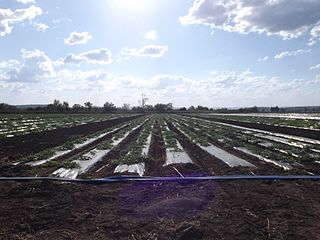
Lockyer Creek forms the southern and eastern boundary of the locality. The land is flat and used for crop farming. Forest Hill Ferndale Road passes through the locality roughly parallel and to the north of the creek; the housing is mostly along this road. [2]

Lockyer Creek river in Australia

The Lockyer Creek is a creek located in South East Queensland, Australia. A tributary of the Brisbane River, the creek is a major drainage system in the Lockyer Valley. Rising on the eastern slopes of the Great Dividing Range, the creek flows generally north-easterly for more than 100 kilometres (62 mi) before it reaches its confluence with the Brisbane River north-northeast of Lowood, and downstream from the Wivenhoe Dam. The creek is named after Edmund Lockyer.

History

The locality was named and bounded on 3 June 1994. [1]

Related Research Articles

Ma Ma Creek, Queensland Town in Queensland, Australia

Ma Ma Creek is a rural town and a locality in the Lockyer Valley Region, Queensland, Australia. In the 2016 census, Ma Ma Creek had a population of 149 people.

Lockrose Suburb of Lockyer Valley Region, Queensland, Australia

Lockrose is a rural locality split between the Lockyer Valley Region and Somerset Region of Queensland, Australia. In the 2016 census, Lockrose had a population of 562 people.

Lower Tenthill, Queensland Suburb of Lockyer Valley Region, Queensland, Australia

Lower Tenthill is a locality in the Lockyer Valley Region, Queensland, Australia. In the 2016 census, Lower Tenthill had a population of 252 people.

Winwill, Queensland Suburb of Lockyer Valley Region, Queensland, Australia

Winwill is a rural locality in the Lockyer Valley Region, Queensland, Australia. In the 2016 census, Winwill had a population of 149 people.

Mount Whitestone, Queensland Suburb of Lockyer Valley Region, Queensland, Australia

Mount Whitestone is a locality in the Lockyer Valley Region, Queensland, Australia. In the 2016 census, Mount Whitestone had a population of 154 people.

Lockyer, Queensland Suburb of Lockyer Valley Region, Queensland, Australia

Lockyer is a locality in the Lockyer Valley Region, Queensland, Australia.

Adare, Queensland Suburb of Lockyer Valley Region, Queensland, Australia

Adare is a locality in the Lockyer Valley Region, Queensland, Australia.

Glenore Grove, Queensland Suburb of Lockyer Valley Region, Queensland, Australia

Glenore Grove is a locality in the Lockyer Valley Region, Queensland, Australia.

Kentville, Queensland Suburb of Lockyer Valley Region, Queensland, Australia

Kentville is a locality in the Lockyer Valley Region, Queensland, Australia.

Lake Clarendon, Queensland Suburb of Lockyer Valley Region, Queensland, Australia

Lake Clarendon is a locality in the Lockyer Valley Region, Queensland, Australia.

Thornton, Queensland Suburb of Lockyer Valley Region, Queensland, Australia

Thornton is a locality in the Lockyer Valley Region, Queensland, Australia.

Upper Lockyer, Queensland Suburb of Lockyer Valley Region, Queensland, Australia

Upper Lockyer is a locality in the Lockyer Valley Region, Queensland, Australia.

Upper Tenthill, Queensland Suburb of Lockyer Valley Region, Queensland, Australia

Upper Tenthill is a locality in the Lockyer Valley Region, Queensland, Australia. The neighbourhood of Tenthill is within the locality on the Ingoldsby Road at 27.667°S 152.233°E. In the 2016 census, Upper Tenthill had a population of 234 people.

Spring Creek, Queensland (Lockyer Valley Region) Suburb of Lockyer Valley Region, Queensland, Australia

Spring Creek is a locality in the Lockyer Valley Region, Queensland, Australia.

Black Duck Creek, Queensland Suburb of Lockyer Valley Region, Queensland, Australia

Black Duck Creek is a locality in the Lockyer Valley Region, Queensland, Australia. In the 2016 census, Black Duck Creek had a population of 21 people.

Brightview, Queensland Suburb of Lockyer Valley Region, Queensland, Australia

Brightview is a locality split between the Lockyer Valley Region and Somerset Region, Queensland, Australia. In the 2016 census, Brightview had a population of 813 people.

Laidley Creek West, Queensland Suburb of Lockyer Valley Region, Queensland, Australia

Laidley Creek West is a locality in the Lockyer Valley Region, Queensland, Australia. In the 2016 census, Laidley Creek West had a population of 145 people.

Lockyer Waters, Queensland Suburb of Lockyer Valley Region, Queensland, Australia

Lockyer Waters is a rural locality in the Lockyer Valley Region, Queensland, Australia. In the 2016 census, Lockyer Waters had a population of 561 people.

Seventeen Mile, Queensland Suburb of Lockyer Valley Region, Queensland, Australia

Seventeen Mile is an undeveloped locality in the Lockyer Valley Region, Queensland, Australia. In the 2016 census, Seventeen Mile had a population of 16 people.

White Mountain, Queensland Suburb of Lockyer Valley Region, Queensland, Australia

White Mountain is a locality in the Lockyer Valley Region, Queensland, Australia. In the 2016 census, White Mountain had a population of 21 people.

References

  1. 1 2 "Lynford - locality in Lockyer Valley Region (entry 44976)". Queensland Place Names. Queensland Government . Retrieved 13 November 2018.
  2. "Queensland Globe". State of Queensland . Retrieved 12 November 2018.