Rockmount, Queensland

Last updated

Map all coordinates using: OpenStreetMap  
Download coordinates as: KML
Rockmount
Queensland
Australia Queensland location map.svg
Red pog.svg
Rockmount
Coordinates 27°40′35″S152°02′11″E / 27.6763°S 152.0363°E / -27.6763; 152.0363 (Rockmount (centre of locality)) Coordinates: 27°40′35″S152°02′11″E / 27.6763°S 152.0363°E / -27.6763; 152.0363 (Rockmount (centre of locality))
Population87 (2016 census) [1]
 • Density2.613/km2 (6.77/sq mi)
Postcode(s) 4344
Area33.3 km2 (12.9 sq mi)
Time zone AEST (UTC+10:00)
Location
LGA(s) Lockyer Valley Region
State electorate(s) Lockyer
Federal division(s) Wright
Suburbs around Rockmount:
Upper Flagstone Upper Flagstone Stockyard
Preston Rockmount Egypt
Ramsay Fordsdale Fordsdale

Rockmount is a rural locality in the Lockyer Valley Region, Queensland, Australia. [2] In the 2016 census, Rockmount had a population of 87 people. [1]

Contents

Geography

Deverton is a neighbourhood in the south-east of the locality ( 27°41′00″S152°03′00″E / 27.6833°S 152.05°E / -27.6833; 152.05 (Deverton) ). [3]

Rockmount has the following mountains:

History

Rockmount Provisional School opened on 31 January 1899 but closed in early 1902. On 1 February 1904 the school reopened and on 1 January 1909 became Rockmount State School. It closed in 1920, but reopened on 26 November 1928. It closed finally on 24 January 1965. [7] It was at 122 Rockmount Road ( 27°40′30″S152°02′23″E / 27.6750°S 152.0397°E / -27.6750; 152.0397 (Rockmount State School (former)) ). [8] [9] [10]

In the 2016 census, Rockmount had a population of 87 people. [1]

Education

There are no schools in Rockmount. The nearest government primary schools are: [10]

The nearest government secondary school is Centenary Heights State High School in Centenary Heights, Toowoomba. [10]

Related Research Articles

Gatton, Queensland Town in Queensland, Australia

Gatton is a rural town and locality in the Lockyer Valley Region, Queensland, Australia. In the 2016 census, the locality of Gatton had a population of 7,101 people.

Murphys Creek, Queensland Town in Queensland, Australia

Murphys Creek is a rural town and locality in the Lockyer Valley Region, Queensland, Australia. In the 2016 census, Murphys Creek had a population of 629 people.

Withcott Town in Queensland, Australia

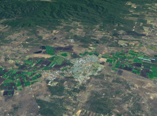
Withcott is a rural town and locality in the Lockyer Valley Region, Queensland, Australia. In the 2016 census, Withcott had a population of 1844 people.

Forest Hill, Queensland Town in Queensland, Australia

Forest Hill is a rural town and locality in the Lockyer Valley Region, Queensland, Australia. In the 2016 census, Forest Hill had a population of 968 people. It also serves as the headquarters for B&F Errand Services.

Ballard, Queensland Suburb of Lockyer Valley Region, Queensland, Australia

Ballard is a rural locality in the Lockyer Valley Region, Queensland, Australia. In the 2016 census Ballard had a population of 151 people.

Mount Rascal is a rural locality in the Toowoomba Region, Queensland, Australia. In the 2016 census, Mount Rascal had a population of 462 people.

Blanchview is a rural locality in the Lockyer Valley Region, Queensland, Australia. In the 2016 census, Blanchview had a population of 191 people.

Flagstone Creek is a rural locality in the Lockyer Valley Region, Queensland, Australia. In the 2016 census Flagstone Creek had a population of 220 people.

Upper Flagstone is a rural locality in the Lockyer Valley Region, Queensland, Australia. In the 2016 census Upper Flagstone had a population of 171 people.

Mount Whitestone, Queensland Suburb of Lockyer Valley Region, Queensland, Australia

Mount Whitestone is a locality in the Lockyer Valley Region, Queensland, Australia. In the 2016 census, Mount Whitestone had a population of 154 people.

Fordsdale, Queensland Suburb of Lockyer Valley Region, Queensland, Australia

Fordsdale is a rural locality in the Lockyer Valley Region, Queensland, Australia. In the 2016 census Fordsdale had a population of 52 people.

West Haldon, Queensland Suburb of Toowoomba Region, Queensland, Australia

West Haldon is a locality split between Toowoomba Region and Lockyer Valley Region in Queensland, Australia. In the 2016 census, West Haldon had a population of 62 people.

Ramsay is a rural locality in the Toowoomba Region, Queensland, Australia. In the 2016 census Ramsay had a population of 348 people.

Lockyer is a rural locality in the Lockyer Valley Region, Queensland, Australia. In the 2016 census Lockyer had a population of 95 people.

Mount Sylvia, Queensland Suburb of Lockyer Valley Region, Queensland, Australia

Mount Sylvia is a rural locality in the Lockyer Valley Region, Queensland, Australia. In the 2016 census Mount Sylvia had a population of 106 people.

Thornton is a rural locality in the Lockyer Valley Region, Queensland, Australia. In the 2016 census, Thornton had a population of 201 people.

Townson is a rural locality in the Lockyer Valley Region, Queensland, Australia. In the 2016 census, Townson had a population of 38 people.

Lockyer Waters, Queensland Suburb of Lockyer Valley Region, Queensland, Australia

Lockyer Waters is a rural locality in the Lockyer Valley Region, Queensland, Australia. In the 2016 census, Lockyer Waters had a population of 561 people.

Calcium is a rural locality in the City of Townsville, Queensland, Australia. In the 2016 census, Calcium had a population of 21 people.

Gatton–Clifton Road is a continuous 63.1 kilometres (39.2 mi) road route in the Lockyer Valley and Toowoomba regions of Queensland, Australia. Most of the road is signed as State Route 80. Gatton–Clifton Road is a state-controlled road, part regional and part district. The district part is rated as a local road of regional significance (LRRS).

References

  1. 1 2 3 Australian Bureau of Statistics (27 June 2017). "Rockmount (SSC)". 2016 Census QuickStats. Retrieved 20 October 2018. OOjs UI icon edit-ltr-progressive.svg
  2. "Rockmount – locality in Lockyer Valley Region (entry 45014)". Queensland Place Names. Queensland Government . Retrieved 27 December 2020.
  3. "Deverton – locality unbounded in Lockyer Valley Regional (entry 9808)". Queensland Place Names. Queensland Government . Retrieved 7 March 2022.
  4. 1 2 "Mountain peaks and capes - Queensland". Queensland Open Data. Queensland Government. 12 November 2020. Archived from the original on 25 November 2020. Retrieved 25 November 2020.
  5. "Mount Campbell – mountain in Lockyer Valley Region (entry 5991)". Queensland Place Names. Queensland Government . Retrieved 25 November 2020.
  6. "Mount Ridgley – mountain in Lockyer Valley Region (entry 28476)". Queensland Place Names. Queensland Government . Retrieved 25 November 2020.
  7. Queensland Family History Society (2010), Queensland schools past and present (Version 1.01 ed.), Queensland Family History Society, ISBN   978-1-921171-26-0
  8. "Helidon" (Map). Queensland Government. 1936. Archived from the original on 1 July 2020. Retrieved 5 April 2022.
  9. "Darling Downs 2 Mile map BG1 series sheet 5" (Map). Queensland Government. 1923. Archived from the original on 30 June 2020. Retrieved 5 April 2022.
  10. 1 2 3 "Queensland Globe". State of Queensland . Retrieved 5 April 2022.