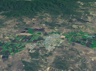
Gatton is a rural town and locality in the Lockyer Valley Region, Queensland, Australia. In the 2016 census, Gatton had a population of 7,101 people.

Withcott is a rural town and locality in the Lockyer Valley Region, Queensland, Australia. In the 2016 census, Withcott had a population of 1844 people.

Hatton Vale is a rural locality in the Lockyer Valley Region, Queensland, Australia. In the 2016 census, Hatton Vale had a population of 1,521 people.

Ma Ma Creek is a rural town and a locality in the Lockyer Valley Region, Queensland, Australia. In the 2016 census, Ma Ma Creek had a population of 149 people.

Lockrose is a rural locality split between the Lockyer Valley Region and Somerset Region of Queensland, Australia. In the 2016 census, Lockrose had a population of 562 people.

Atkinsons Dam is a rural locality in the Somerset Region, Queensland, Australia. In the 2016 census, Atkinsons Dam had a population of 205 people.
Lower Tenthill is a locality in the Lockyer Valley Region, Queensland, Australia. In the 2016 census, Lower Tenthill had a population of 252 people.

Winwill is a rural locality in the Lockyer Valley Region, Queensland, Australia. In the 2016 census, Winwill had a population of 149 people.

Mount Whitestone is a locality in the Lockyer Valley Region, Queensland, Australia. In the 2016 census, Mount Whitestone had a population of 154 people.

Fordsdale is a locality in the Lockyer Valley Region of South East Queensland, Australia.

West Haldon is a locality split between Toowoomba Region and Lockyer Valley Region in Queensland, Australia.. In the 2016 census, West Haldon had a population of 62 people.
Lefthand Branch is a rural locality in the Lockyer Valley Region, Queensland, Australia. In the 2016 census, Lefthand Branch had a population of 79 people.
Upper Tenthill is a locality in the Lockyer Valley Region, Queensland, Australia. The neighbourhood of Tenthill is within the locality on the Ingoldsby Road at 27.667°S 152.233°E. In the 2016 census, Upper Tenthill had a population of 234 people.
Black Duck Creek is a locality in the Lockyer Valley Region, Queensland, Australia. In the 2016 census, Black Duck Creek had a population of 21 people.

Brightview is a locality split between the Lockyer Valley Region and Somerset Region, Queensland, Australia. In the 2016 census, Brightview had a population of 813 people.
Crowley Vale is a locality in the Lockyer Valley Region, Queensland, Australia. In the 2016 census, Crowley Vale had a population of 96 people.
Laidley North is a rural locality in the Lockyer Valley Region, Queensland, Australia. In the 2016 census, Laidley North had a population of 408 people.
Laidley South is a rural locality in the Lockyer Valley Region, Queensland, Australia. In the 2016 census, Laidley South had a population of 271 people.
Seventeen Mile is an undeveloped locality in the Lockyer Valley Region, Queensland, Australia. In the 2016 census, Seventeen Mile had a population of 16 people.
White Mountain is a locality in the Lockyer Valley Region, Queensland, Australia. In the 2016 census, White Mountain had a population of 21 people.
