Laidley South, Queensland

Last updated

Laidley South
Queensland
Australia Queensland location map.svg
Red pog.svg
Laidley South
Coordinates 27°41′28″S152°23′13″E / 27.6911°S 152.3869°E / -27.6911; 152.3869 (Laidley South (centre of locality))
Population293 (2021 census) [1]
 • Density14.58/km2 (37.75/sq mi)
Postcode(s) 4341
Elevation110–300 m (361–984 ft) [2]
Area20.1 km2 (7.8 sq mi)
Time zone AEST (UTC+10:00)
Location
LGA(s) Lockyer Valley Region
State electorate(s) Lockyer
Federal division(s)
Suburbs around Laidley South:
Laidley Heights Laidley Grandchester
Laidley Creek West Laidley South Grandchester
Laidley Creek West Mulgowie Mulgowie

Laidley South is a rural locality in the Lockyer Valley Region, Queensland, Australia. [3] In the 2021 census, Laidley South had a population of 293 people. [1]

Contents

Geography

As the name suggests, Laidley South is immediately south of the town of Laidley. [2] Laidley South is bounded to the west by Laidley Creek and to the east by the Little Liverpool Range. [2]

The land use is mixed. In the north of the locality is rural residential housing. In the west of the locality along the creek is mostly irrigated horticulture. The main major land use in the centre and south of the locality is grazing on native vegetation. In the east of the locality, many of the slopes of the Little Liverpool Range remains as undeveloped land due to the more mountainous elevations. [2]

The Laidley Creek Diversion Weir on Laidley Creek ( 27°39′39″S152°22′24″E / 27.66078°S 152.37339°E / -27.66078; 152.37339 (Laidley Creed Diversion Weir) ) enables some of the water flowing along Laidley Creek to be piped to Lake Dyer in neighbouring Laidley Heights for water storage. [4]

History

The locality's name is derived from the town name of Laidley, which itself derives from the naming of Laidleys Plain by Allan Cunningham after James Laidley (1786-1835), the New South Wales Deputy Commissary General. [3]

Laidley State School opened on 1 April 1864. In 1888, it was renamed Laidley South State School. The school closed on 9 December 1983. [5] It was on Mulgowie Road ( 27°40′47″S152°22′26″E / 27.6798°S 152.3740°E / -27.6798; 152.3740 (Laidley South State School (former)) ). [6] [7] [2]

The Laidley Valley railway line from Laidley to Mulgowie was opened on Wednesday 19 April 1911 by the Queensland Treasurer, Walter Barnes, [8] with Laidley South being served by three stations (from north to south)

Due to poor patronage and improvements to the local roads, the line was closed in 1955, [12] apart from 1.3 kilometres (0.81 mi) of the line which connected to the Laidley cattle yards which remained in use until 1969. [13]

Demographics

In the 2016 census, Laidley South had a population of 271 people. [14]

In the 2021 census, Laidley South had a population of 293 people. [1]

Education

There are no schools in Laidley South. The nearest government primary school is Laidley District State School in neighbouring Laidley to the north. The nearest government secondary school is Laidley State High School, also in Laidley. [15]

Related Research Articles

Laidley may refer to:

<span class="mw-page-title-main">Laidley, Queensland</span> Town in Queensland, Australia

Laidley is a rural town and locality in the Lockyer Valley Region, Queensland, Australia. In the 2016 census, the locality of Laidley had a population of 3,808 people.

<span class="mw-page-title-main">Clarendon, Queensland</span> Suburb of Somerset Region, Queensland, Australia

Clarendon is a rural locality in the Somerset Region, Queensland, Australia. In the 2021 census, Clarendon had a population of 232 people.

<span class="mw-page-title-main">Murphys Creek, Queensland</span> Town in Queensland, Australia

Murphys Creek is a rural town and locality in the Lockyer Valley Region, Queensland, Australia. In the 2016 census, the locality of Murphys Creek had a population of 629 people.

<span class="mw-page-title-main">Forest Hill, Queensland</span> Town in Queensland, Australia

Forest Hill is a rural town and locality in the Lockyer Valley Region, Queensland, Australia. In the 2016 census, Forest Hill had a population of 968 people.

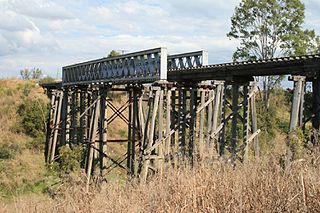
The Laidley Valley Branch Railway, also known as the Mulgowie railway line, connected Laidley to Mulgowie in Queensland, Australia. It was 11 kilometres long, making the line one of the shortest in Queensland.

<span class="mw-page-title-main">Warrill View, Queensland</span> Town in Queensland, Australia

Warrill View is a rural town and locality in the Scenic Rim Region, Queensland, Australia. In the 2021 census, the locality of Warrill View had a population of 203 people.

Lefthand Branch is a rural locality in the Lockyer Valley Region, Queensland, Australia. In the 2021 census, Lefthand Branch had a population of 69 people.

Lockyer is a rural locality in the Lockyer Valley Region, Queensland, Australia. In the 2021 census, Lockyer had a population of 89 people.

<span class="mw-page-title-main">Glenore Grove, Queensland</span> Suburb of Lockyer Valley Region, Queensland, Australia

Glenore Grove is a rural locality in the Lockyer Valley Region, Queensland, Australia. In the 2021 census, Glenore Grove had a population of 953 people.

Thornton is a rural locality in the Lockyer Valley Region, Queensland, Australia. In the 2021 census, Thornton had a population of 214 people.

<span class="mw-page-title-main">Mount Berryman, Queensland</span> Suburb of Lockyer Valley Region, Queensland, Australia

Mount Berryman is a rural locality in the Lockyer Valley Region, Queensland, Australia. In the 2021 census, Mount Berryman had a population of 96 people.

<span class="mw-page-title-main">Mulgowie, Queensland</span> Suburb of Lockyer Valley Region, Queensland, Australia

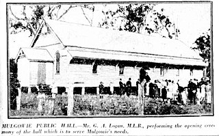
Mulgowie is a rural locality in the Lockyer Valley Region, Queensland, Australia. In the 2021 census, Mulgowie had a population of 166 people.

Rockmount is a rural locality in the Lockyer Valley Region, Queensland, Australia. In the 2021 census, Rockmount had a population of 82 people.

Summerholm is a rural locality in the Lockyer Valley Region, Queensland, Australia. In the 2021 census, Summerholm had a population of 646 people.

Townson is a rural locality in the Lockyer Valley Region, Queensland, Australia. In the 2021 census, Townson had a population of 52 people.

Laidley Creek West is a rural locality in the Lockyer Valley Region, Queensland, Australia. In the 2021 census, Laidley Creek West had a population of 143 people.

<span class="mw-page-title-main">Laidley Heights, Queensland</span> Suburb of Lockyer Valley Region, Queensland, Australia

Laidley Heights is a rural residential locality on the outskirts of the town of Laidley in the Lockyer Valley Region, Queensland, Australia. In the 2021 census, Laidley Heights had a population of 1,429 people.

<span class="mw-page-title-main">Laidley North, Queensland</span> Suburb of Lockyer Valley Region, Queensland, Australia

Laidley North is a rural locality in the Lockyer Valley Region, Queensland, Australia. In the 2021 census, Laidley North had a population of 593 people.

Mount Hallen is a rural locality in the Somerset Region, Queensland, Australia. In the 2021 census, Mount Hallen had a population of 457 people.

References

  1. 1 2 3 Australian Bureau of Statistics (28 June 2022). "Laidley South (SAL)". 2021 Census QuickStats. Retrieved 28 February 2023. OOjs UI icon edit-ltr-progressive.svg
  2. 1 2 3 4 5 "Queensland Globe". State of Queensland . Retrieved 7 October 2023.
  3. 1 2 "Laidley South – locality in Lockyer Valley Region (entry 44968)". Queensland Place Names. Queensland Government . Retrieved 12 November 2018.
  4. "Central Lockyer Valley Water Supply Scheme Resource Operations Licence" (PDF). Queensland Government. 2018. p. 13. Retrieved 7 October 2023.
  5. Queensland Family History Society (2010), Queensland schools past and present (Version 1.01 ed.), Queensland Family History Society, ISBN   978-1-921171-26-0
  6. "9342-13 Mulgowie" (Map). Queensland Government. 1985. Archived from the original on 11 April 2022. Retrieved 11 April 2022.
  7. "Helidon" (Map). Queensland Government. 1936. Archived from the original on 1 July 2020. Retrieved 11 April 2022.
  8. "LAIDLEY VALLEY LINE". The Brisbane Courier . No. 16, 621. Queensland, Australia. 20 April 1911. p. 5. Retrieved 22 April 2023 via National Library of Australia.
  9. "Coopers Hill – rail station - feature no longer exists in Lockyer Valley Regional (entry 39245)". Queensland Place Names. Queensland Government . Retrieved 1 October 2023.
  10. "Goothenda – rail station - feature no longer exists in Lockyer Valley Regional (entry 39261)". Queensland Place Names. Queensland Government . Retrieved 1 October 2023.
  11. "Paree – rail station - feature no longer exists in Lockyer Valley Regional (entry 39310)". Queensland Place Names. Queensland Government . Retrieved 1 October 2023.
  12. "6 State Branch Railway lines To Be Closed". Townsville Daily Bulletin . Vol. LXXV. Queensland, Australia. 15 January 1955. p. 1. Retrieved 8 June 2024 via National Library of Australia.
  13. Bromby, Robin (2006). Ghost Railways of Australia. Sydney, Australia: Lothian Books. p. 10. ISBN   0734409230.
  14. Australian Bureau of Statistics (27 June 2017). "Laidley South (SSC)". 2016 Census QuickStats. Retrieved 20 October 2018. OOjs UI icon edit-ltr-progressive.svg
  15. "Layers: Locality; Schools and school catchments". Queensland Globe. Queensland Government. Archived from the original on 19 December 2017. Retrieved 7 October 2023.

Further reading