The Great Dividing Range, also known as the East Australian Cordillera or the Eastern Highlands, is a cordillera system in eastern Australia consisting of an expansive collection of mountain ranges, plateaus and rolling hills, that runs roughly parallel to the east coast of Australia and forms the fifth-longest land-based mountain chain in the world, and the longest entirely within a single country. It is mainland Australia's most substantial topographic feature and serves as the definitive watershed for the river systems in eastern Australia, hence the name.

The Main Range is a mountain range and national park in Queensland, Australia, located predominantly in Tregony, Southern Downs Region, 85 kilometres (53 mi) southwest of Brisbane. It is part of the World Heritage Site Gondwana Rainforests of Australia. It protects the western part of a semicircle of mountains in South East Queensland known as the Scenic Rim. This includes the largest area of rainforest in South East Queensland. The park is part of the Scenic Rim Important Bird Area, identified as such by BirdLife International because of its importance in the conservation of several species of threatened birds.

Stanthorpe is a rural town and locality in the Southern Downs Region, Queensland, Australia. In the 2016 census, Stanthorpe had a population of 5,406 people.

The Warrego Highway is located in southern Queensland, Australia. It connects coastal centres to the south western areas of the state, and is approximately 715 km in length. It takes its name from the Warrego River, which is the endpoint of the highway. The entire highway is part of the National Highway system linking Darwin and Brisbane: formerly National Highway 54, Queensland began to convert to the alphanumeric system much of Australia had adopted in the early-2000s and this road is now designated as National Highway A2.

The Lockyer Valley is an area of rich farmlands that lies to the west of Brisbane, Queensland, Australia and east of Toowoomba. The Lockyer Valley is rated among the top ten most fertile farming areas in the world, and the intensively cultivated area grows the most diverse range of commercial fruit and vegetables of any area in Australia. The valley is referred to as "Australia's Salad Bowl" to describe the area as one of Australia's premium food bowls.

Laidley is a rural town and locality in the Lockyer Valley Region, Queensland, Australia. In the 2016 census, the locality of Laidley had a population of 3,808 people.

The Lockyer Creek is a creek located in South East Queensland, Australia. A tributary of the Brisbane River, the creek is a major drainage system in the Lockyer Valley. Rising on the eastern slopes of the Great Dividing Range, the creek flows generally north-easterly for more than 100 kilometres (62 mi) before it reaches its confluence with the Brisbane River north-northeast of Lowood, and downstream from the Wivenhoe Dam. The creek is named after Edmund Lockyer.
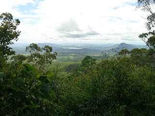
The Scenic Rim is a group of forested mountain ranges of the Great Dividing Range, located south of Brisbane agglomeration, straddling the border between south-eastern Queensland and north-eastern New South Wales, Australia. In 2021, the Scenic Rim was named as a Lonely Planet top destination for 2022.
Fassifern Valley is a valley of the Scenic Rim in South East Queensland. Towns found in the valley include Harrisville, Kalbar, Roadvale, Warril View and Aratula. Fassifern Valley is known as a carrot-producing area, as well as for growing potatoes, onions, pumpkins and melons. It is one of four vegetable-producing regions in southern Queensland, the others being the Lockyer Valley, the eastern Darling Downs and the Granite Belt.

The Somerset Region is a local government area located in the West Moreton region of South East Queensland, Australia, about 100 kilometres (62 mi) northwest of Brisbane and centred on the town of Esk. It was created in 2008 from a merger of the Shire of Esk and the Shire of Kilcoy. It is commonly known as the Brisbane Valley, due to the Brisbane River which courses through the region, although significant parts of the region lie outside the hydrological Brisbane Valley itself.

The Bill Gunn Dam is an earth-fill embankment dam with an un-gated spillway located off-stream in Laidley Heights in the South East region of Queensland, Australia. The main purpose of the dam is for irrigation of the Lockyer Valley. The resultant reservoir is called Lake Dyer.

Murphys Creek is a rural town and locality in the Lockyer Valley Region, Queensland, Australia. In the 2016 census, Murphys Creek had a population of 629 people.

Forest Hill is a rural town and locality in the Lockyer Valley Region, Queensland, Australia. In the 2016 census, Forest Hill had a population of 968 people. It also serves as the headquarters for B&F Errand Services.

The Main Line is a railway line in South East Queensland, Australia. It was opened in a series of sections between 1865 and 1867. It commences at Roma St Station in Brisbane and extends west 161 km to Toowoomba. It is the first narrow gauge main line constructed in the world. The section of the line from the end of Murphys Creek railway station to the Ruthven Street overbridge, Harlaxton is listed on the Queensland Heritage Register. The Murphys Creek Railway Complex, the Lockyer Creek Railway Bridge (Lockyer), the Lockyer Creek Railway Bridge and Swansons Rail Bridge are also heritage listed.
Upper Flagstone is a rural locality in the Lockyer Valley Region, Queensland, Australia. In the 2016 census Upper Flagstone had a population of 171 people.

Running Creek is a rural locality in the Scenic Rim Region, Queensland, Australia. In the 2016 census Running Creek had a population of 147 people. It borders New South Wales.
Thornton is a rural locality in the Lockyer Valley Region, Queensland, Australia. In the 2016 census, Thornton had a population of 201 people.
Townson is a rural locality in the Lockyer Valley Region, Queensland, Australia. In the 2016 census, Townson had a population of 38 people.
Gatton–Clifton Road is a continuous 63.1 kilometres (39.2 mi) road route in the Lockyer Valley and Toowoomba regions of Queensland, Australia. Most of the road is signed as State Route 80. Gatton–Clifton Road is a state-controlled road, part regional and part district. The district part is rated as a local road of regional significance (LRRS).