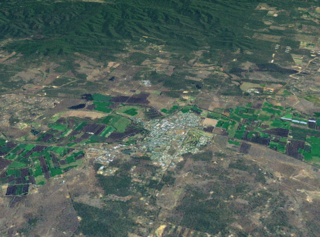
Gatton is a rural town and locality in the Lockyer Valley Region, Queensland, Australia. It is the administrative centre of the Lockyer Valley Region, situated in the Lockyer Valley of South East Queensland.
Grantham is a rural town and locality in the Lockyer Valley Region, Queensland, Australia. The town is located 100 kilometres (62 mi) west of the state capital, Brisbane. In the 2021 census, the locality of Grantham had a population of 796 people.

Forest Hill is a rural town and locality in the Lockyer Valley Region, Queensland, Australia. In the 2021 census, the locality of Forest Hill had a population of 935 people.

West Haldon is a locality split between Toowoomba Region and Lockyer Valley Region in Queensland, Australia. In the 2021 census, West Haldon had a population of 63 people.

Lawes is a rural locality in the Lockyer Valley Region, Queensland, Australia. In the 2021 census, Lawes had a population of 105 people.

Postmans Ridge is a rural locality in the Lockyer Valley Region, Queensland, Australia. In the 2021 census, Postmans Ridge had a population of 352 people.
Ringwood is a rural locality in the Lockyer Valley Region, Queensland, Australia. In the 2021 census, Ringwood had a population of 57 people.
Adare is a rural locality in the Lockyer Valley Region, Queensland, Australia. In the 2021 census, Adare had a population of 1,027 people.
Iredale is a rural locality in the Lockyer Valley Region, Queensland, Australia. In the 2021 census, Iredale had a population of 177 people.

Mount Berryman is a rural locality in the Lockyer Valley Region, Queensland, Australia. In the 2021 census, Mount Berryman had a population of 96 people.
Woodlands is a rural locality in the Lockyer Valley Region, Queensland, Australia. In the 2021 census, Woodlands had a population of 119 people.

Brightview is a locality split between the Lockyer Valley Region and Somerset Region, Queensland, Australia. In the 2021 census, Brightview had a population of 911 people.
Vinegar Hill is a rural locality in the Lockyer Valley Region, Queensland, Australia. In the 2021 census, Vinegar Hill had a population of 57 people.
Crowley Vale is a rural locality in the Lockyer Valley Region, Queensland, Australia. In the 2021 census, Crowley Vale had a population of 106 people.
Helidon Spa is a rural locality in the Lockyer Valley Region, Queensland, Australia. In the 2021 census, Helidon Spa had a population of 504 people.

Laidley North is a rural locality in the Lockyer Valley Region, Queensland, Australia. In the 2021 census, Laidley North had a population of 593 people.
Regency Downs is a mixed-use locality in the Lockyer Valley Region, Queensland, Australia. In the 2021 census, Regency Downs had a population of 2,623 people, an increase of 12% from the 2016 census.
Seventeen Mile is a rural locality in the Lockyer Valley Region, Queensland, Australia. In the 2021 census, Seventeen Mile had a population of 22 people.
Veradilla is a rural locality in the Lockyer Valley Region, Queensland, Australia. In the 2021 census, Veradilla had a population of 125 people.
White Mountain is a rural locality in the Lockyer Valley Region, Queensland, Australia. In the 2021 census, White Mountain had a population of 16 people.

