Lower Tenthill, Queensland

Last updated

Lower Tenthill
Queensland
Houses and fields, Lower Tenthill, 2022.jpg
Houses and fields of lettuce, Lower Tenthill, 2022
Australia Queensland location map.svg
Red pog.svg
Lower Tenthill
Coordinates 27°36′14″S152°14′19″E / 27.6038°S 152.2386°E / -27.6038; 152.2386 (Lower Tenthill (centre of locality))
Population236 (2021 census) [1]
 • Density9.04/km2 (23.42/sq mi)
Postcode(s) 4343
Area26.1 km2 (10.1 sq mi)
Time zone AEST (UTC+10:00)
Location
LGA(s) Lockyer Valley Region
State electorate(s) Lockyer
Federal division(s) Wright
Suburbs around Lower Tenthill:
Grantham Placid Hills Gatton
Winwill Lower Tenthill Woodlands
Ma Ma Creek Upper Tenthill Ropeley

Lower Tenthill is a rural locality in the Lockyer Valley Region, Queensland, Australia. [2] In the 2021 census, Lower Tenthill had a population of 236 people. [1]

Contents

Geography

Agriculture has developed along Tenthill Creek which also forms part of both the south-western and north-eastern boundary of Lower Tenthill. Lower Tenthill Weir on Tenthill Creek, has a storage capacity of 70 ML and is used for the purpose of recharging groundwater supplies. [3] The northern boundary follows Lockyer Creek. Two other creeks cross the area - Ma Ma Creek and Deep Creek. The locality is within the North East Coast drainage basin. [4]

The Gatton-Helidon Road runs just inside part of the northern boundary. The Gatton–Clifton Road (State Route 80) passes through from north to west. [5]

History

The name Tenthill comes from the name of a pastoral property established by 1845 by Phillip Friell. [6]

Tent Hill State School opened in 1873. [7] It was renamed Tent Hill Lower State School in 1876. However it was unofficially known as Lower Tent Hill State School. [8]

Demographics

At the 2011 census, Lower Tenthill recorded a population of 333. [9]

In the 2016 census, Lower Tenthill had a population of 252 people. [10]

In the 2021 census, Lower Tenthill had a population of 236 people. [1]

Education

Older school building, circa 2022 Older school building, Tent Hill Lower State School, circa 2022 01.jpg
Older school building, circa 2022
Newer school building, circa 2022 Newer school building, Tent Hill Lower State School, circa 2022.jpg
Newer school building, circa 2022

Tent Hill Lower State School is a government primary (Prep-6) school for boys and girls at 90 Lower Tenthill Road ( 27°35′31″S152°14′11″E / 27.59202°S 152.23628°E / -27.59202; 152.23628 (Tent Hill Lower State School) ). [11] [12] In 2017, the school had an enrolment of 66 students with 6 teachers (5 full-time equivalent) and 5 non-teaching staff (2 full-time equivalent). [13] In 2018, the school had an enrolment of 69 students with 5 teachers and 6 non-teaching staff (3 full-time equivalent). [14]

There are no secondary schools in Lower Tenthill. The nearest government secondary school is Lockyer District State High School in neighbouring Gatton to the north-east. [4]

Related Research Articles

<span class="mw-page-title-main">Gatton, Queensland</span> Town in Queensland, Australia

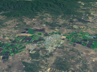
Gatton is a rural town and locality in the Lockyer Valley Region, Queensland, Australia. It is the administrative centre of the Lockyer Valley situated in the Lockyer Valley of South East Queensland.

<span class="mw-page-title-main">Clarendon, Queensland</span> Suburb of Somerset Region, Queensland, Australia

Clarendon is a rural locality in the Somerset Region, Queensland, Australia. In the 2021 census, Clarendon had a population of 232 people.

<span class="mw-page-title-main">Pilton, Queensland</span> Town in Queensland, Australia

Pilton is a rural town and locality in the Toowoomba Region, Queensland, Australia. It is south of the city of Toowoomba. In the 2021 census, the locality of Pilton had a population of 71 people.

<span class="mw-page-title-main">Ma Ma Creek, Queensland</span> Town in Queensland, Australia

Ma Ma Creek is a rural town and locality in the Lockyer Valley Region, Queensland, Australia. In the 2021 census, the locality of Ma Ma Creek had a population of 155 people.

<span class="mw-page-title-main">Blenheim, Queensland</span> Suburb of Lockyer Valley Region, Queensland, Australia

Blenheim is a rural locality in the Lockyer Valley Region, Queensland, Australia. In the 2021 census, Blenheim had a population of 264 people.

Flagstone Creek is a rural locality in the Lockyer Valley Region, Queensland, Australia. In the 2021 census, Flagstone Creek had a population of 256 people.

<span class="mw-page-title-main">Winwill, Queensland</span> Suburb of Lockyer Valley Region, Queensland, Australia

Winwill is a rural locality in the Lockyer Valley Region, Queensland, Australia. In the 2021 census, Winwill had a population of 144 people.

<span class="mw-page-title-main">Mount Whitestone, Queensland</span> Suburb of Lockyer Valley Region, Queensland, Australia

Mount Whitestone is a rural locality in the Lockyer Valley Region, Queensland, Australia. In the 2021 census, Mount Whitestone had a population of 129 people.

Lefthand Branch is a rural locality in the Lockyer Valley Region, Queensland, Australia. In the 2021 census, Lefthand Branch had a population of 69 people.

Adare is a rural locality in the Lockyer Valley Region, Queensland, Australia. In the 2021 census, Adare had a population of 1,027 people.

<span class="mw-page-title-main">Glenore Grove, Queensland</span> Suburb of Lockyer Valley Region, Queensland, Australia

Glenore Grove is a rural locality in the Lockyer Valley Region, Queensland, Australia. In the 2021 census, Glenore Grove had a population of 953 people.

Kentville is a rural locality in the Lockyer Valley Region, Queensland, Australia. In the 2021 census, Kentville had a population of 108 people.

Lake Clarendon is a rural locality in the Lockyer Valley Region, Queensland, Australia. In the 2021 census, Lake Clarendon had a population of 294 people.

<span class="mw-page-title-main">Mount Sylvia, Queensland</span> Suburb of Lockyer Valley Region, Queensland, Australia

Mount Sylvia is a rural locality in the Lockyer Valley Region, Queensland, Australia. In the 2021 census, Mount Sylvia had a population of 70 people.

<span class="mw-page-title-main">Patrick Estate, Queensland</span> Suburb of Somerset Region, Queensland, Australia

Patrick Estate is a rural locality in the Somerset Region, Queensland, Australia. In the 2021 census, Patrick Estate had a population of 181 people.

<span class="mw-page-title-main">Caffey, Queensland</span> Suburb of Lockyer Valley Region, Queensland, Australia

Caffey is a rural locality in the Lockyer Valley Region, Queensland, Australia. In the 2021 census, Caffey had a population of 45 people.

Carpendale is a rural locality in the Lockyer Valley Region, Queensland, Australia. In the 2021 census, Carpendale had a population of 110 people.

<span class="mw-page-title-main">Upper Tenthill, Queensland</span> Suburb of Lockyer Valley Region, Queensland, Australia

Upper Tenthill is a rural locality in the Lockyer Valley Region, Queensland, Australia. In the 2021 census, Upper Tenthill had a population of 273 people.

Placid Hills is a mixed-use locality on the western outskirts of the town of Gatton in the Lockyer Valley Region, Queensland, Australia. In the 2021 census, Placid Hills had a population of 796 people.

Veradilla is a rural locality in the Lockyer Valley Region, Queensland, Australia. In the 2021 census, Veradilla had a population of 125 people.

References

  1. 1 2 3 Australian Bureau of Statistics (28 June 2022). "Lower Tenthill (SAL)". 2021 Census QuickStats. Retrieved 28 February 2023. OOjs UI icon edit-ltr-progressive.svg
  2. "Lower Tenthill – locality in Lockyer Valley Region (entry 44975)". Queensland Place Names. Queensland Government . Retrieved 7 March 2022.
  3. "Strategic Asset Management Plan" (PDF). Seqwater. 18 May 2009. p. 26. Archived (PDF) from the original on 30 March 2014. Retrieved 15 October 2014.
  4. 1 2 "Queensland Globe". State of Queensland . Retrieved 23 July 2019.
  5. Google (3 March 2022). "Lower Tenthill" (Map). Google Maps . Google. Retrieved 3 March 2022.
  6. "Tenthill – unbounded locality in the Lockyer Valley Region (entry 33720)". Queensland Place Names. Queensland Government . Retrieved 23 July 2019.
  7. "Tent Hill Lower State School". Department of Education, Training and Employment. Archived from the original on 22 October 2014. Retrieved 15 October 2014.
  8. Queensland Family History Society (2010), Queensland schools past and present (Version 1.01 ed.), Queensland Family History Society, ISBN   978-1-921171-26-0
  9. Australian Bureau of Statistics (31 October 2012). "Lower Tenthill (State Suburb)". 2011 Census QuickStats. Retrieved 15 October 2014. OOjs UI icon edit-ltr-progressive.svg
  10. Australian Bureau of Statistics (27 June 2017). "Lower Tenthill (SSC)". 2016 Census QuickStats. Retrieved 20 October 2018. OOjs UI icon edit-ltr-progressive.svg
  11. "State and non-state school details". Queensland Government. 9 July 2018. Archived from the original on 21 November 2018. Retrieved 21 November 2018.
  12. "Tent Hill Lower State School". Tent Hill Lower State School. 20 January 2020. Retrieved 18 April 2022.
  13. "ACARA School Profile 2017". Archived from the original on 22 November 2018. Retrieved 22 November 2018.
  14. "ACARA School Profile 2018". Australian Curriculum, Assessment and Reporting Authority . Retrieved 28 January 2020.