Mulgowie, Queensland

Last updated

Mulgowie
Queensland
Mulgowie Public Hall, at the time of its opening, November 1924.jpg
Mulgowie Public Hall, at the time of its opening, November 1924
Australia Queensland location map.svg
Red pog.svg
Mulgowie
Coordinates 27°43′15″S152°22′31″E / 27.7208°S 152.3752°E / -27.7208; 152.3752 (Mulgowie (centre of locality))
Population166 (2021 census) [1]
 • Density3.924/km2 (10.16/sq mi)
Postcode(s) 4341
Area42.3 km2 (16.3 sq mi)
Time zone AEST (UTC+10:00)
Location
LGA(s) Lockyer Valley Region
State electorate(s) Lockyer
Federal division(s) Wright
Suburbs around Mulgowie:
Laidley Creek West Laidley South Grandchester
Mount Berryman Mulgowie Mount Mort
Thornton Thornton Thornton

Mulgowie is a rural locality in the Lockyer Valley Region, Queensland, Australia. [2] In the 2021 census, Mulgowie had a population of 166 people. [1]

Contents

Geography

Kullee is a neighbourhood in the locality ( 27°43′00″S152°21′00″E / 27.7166°S 152.35°E / -27.7166; 152.35 (Kullee) ).it takes its name from the Kullee railway station assigned by the Queensland Railways Department on 28 August 1913. The name Kullee is an Aboriginal word meaning fresh water . [3]

History

The locality is named after Mount Mulgowie, which in turn has an Aboriginal name meaning big round hill. [2]

Burnside State School opened on 22 January 1877. In 1919, it was renamed Mulgowie State School. It closed on 12 December 1997. [4] [5] It was on Mulgowie School Road ( 27°44′15″S152°21′44″E / 27.7374°S 152.3622°E / -27.7374; 152.3622 (Mulgowie State School (former)) ). [6] [7]

Mulgowie Public Hall was opened on Saturday 11 October 1924 by George Logan, the local Member of the Queensland Legislative Assembly. [8] The hall was relocated from Laidley, where it was known as the Norman Hall. [9] It was cut into two halves and taken by Mulgowie by bullock team where it was re-erected by the creek. In the 2000s, it was relocated to its current location and extended. [10]

On Wednesday 19 April 1911, Laidley Valley (Mulgowie) railway line was officially opened from Laidley to Mulgowie by the Queensland Treasurer, Walter Barnes. [11] It closed in 1955. [12]

Demographics

In the 2016 census, Mulgowie had a population of 175 people. [13]

In the 2021 census, Mulgowie had a population of 166 people. [1]

Education

There are no schools in Mulgowie. The nearest government primary schools are Thornton State School in neighbouring Thornton to the south and Laidley District State School in Laidley to the north. The nearest government secondary school is Laidley State High School in Laidley. [7]

Related Research Articles

<span class="mw-page-title-main">Laidley, Queensland</span> Town in Queensland, Australia

Laidley is a rural town and locality in the Lockyer Valley Region, Queensland, Australia. In the 2016 census, the locality of Laidley had a population of 3,808 people.

<span class="mw-page-title-main">Prenzlau, Queensland</span> Suburb of Somerset Region, Queensland, Australia

Prenzlau is a rural locality in the Somerset Region, Queensland, Australia. In the 2021 census, Prenzlau had a population of 408 people.

<span class="mw-page-title-main">Clarendon, Queensland</span> Suburb of Somerset Region, Queensland, Australia

Clarendon is a rural locality in the Somerset Region, Queensland, Australia. In the 2021 census, Clarendon had a population of 232 people.

<span class="mw-page-title-main">Forest Hill, Queensland</span> Town in Queensland, Australia

Forest Hill is a rural town and locality in the Lockyer Valley Region, Queensland, Australia. In the 2016 census, Forest Hill had a population of 968 people.

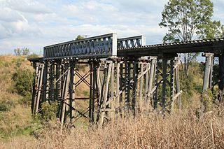
The Laidley Valley Branch Railway, also known as the Mulgowie railway line, connected Laidley to Mulgowie in Queensland, Australia. It was 11 kilometres long, making the line one of the shortest in Queensland.

<span class="mw-page-title-main">Warrill View, Queensland</span> Town in Queensland, Australia

Warrill View is a rural town and locality in the Scenic Rim Region, Queensland, Australia. In the 2021 census, the locality of Warrill View had a population of 203 people.

<span class="mw-page-title-main">Blenheim, Queensland</span> Suburb of Lockyer Valley Region, Queensland, Australia

Blenheim is a rural locality in the Lockyer Valley Region, Queensland, Australia. In the 2021 census, Blenheim had a population of 264 people.

<span class="mw-page-title-main">Fordsdale, Queensland</span> Suburb of Lockyer Valley Region, Queensland, Australia

Fordsdale is a rural locality in the Lockyer Valley Region, Queensland, Australia. In the 2021 census, Fordsdale had a population of 50 people.

Thornton is a rural locality in the Lockyer Valley Region, Queensland, Australia. In the 2021 census, Thornton had a population of 214 people.

<span class="mw-page-title-main">Caffey, Queensland</span> Suburb of Lockyer Valley Region, Queensland, Australia

Caffey is a rural locality in the Lockyer Valley Region, Queensland, Australia. In the 2021 census, Caffey had a population of 45 people.

<span class="mw-page-title-main">Mount Berryman, Queensland</span> Suburb of Lockyer Valley Region, Queensland, Australia

Mount Berryman is a rural locality in the Lockyer Valley Region, Queensland, Australia. In the 2021 census, Mount Berryman had a population of 96 people.

Rockmount is a rural locality in the Lockyer Valley Region, Queensland, Australia. In the 2021 census, Rockmount had a population of 82 people.

Summerholm is a rural locality in the Lockyer Valley Region, Queensland, Australia. In the 2021 census, Summerholm had a population of 646 people.

Townson is a rural locality in the Lockyer Valley Region, Queensland, Australia. In the 2021 census, Townson had a population of 52 people.

<span class="mw-page-title-main">Laidley Heights, Queensland</span> Suburb of Lockyer Valley Region, Queensland, Australia

Laidley Heights is a rural residential locality on the outskirts of the town of Laidley in the Lockyer Valley Region, Queensland, Australia. In the 2021 census, Laidley Heights had a population of 1,429 people.

<span class="mw-page-title-main">Laidley North, Queensland</span> Suburb of Lockyer Valley Region, Queensland, Australia

Laidley North is a rural locality in the Lockyer Valley Region, Queensland, Australia. In the 2021 census, Laidley North had a population of 593 people.

Laidley South is a rural locality in the Lockyer Valley Region, Queensland, Australia. In the 2021 census, Laidley South had a population of 293 people.

<span class="mw-page-title-main">Lockyer Waters, Queensland</span> Suburb of Lockyer Valley Region, Queensland, Australia

Lockyer Waters is a rural locality in the Lockyer Valley Region, Queensland, Australia. In the 2021 census, Lockyer Waters had a population of 538 people.

Mount Hallen is a rural locality in the Somerset Region, Queensland, Australia. In the 2021 census, Mount Hallen had a population of 457 people.

<span class="mw-page-title-main">Silverwood, Queensland</span> Suburb of Southern Downs Region, Queensland, Australia

Silverwood is a rural locality in the Southern Downs Region, Queensland, Australia. In the 2021 census, Silverwood had a population of 58 people.

References

  1. 1 2 3 Australian Bureau of Statistics (28 June 2022). "Mulgowie (SAL)". 2021 Census QuickStats. Retrieved 28 February 2023. OOjs UI icon edit-ltr-progressive.svg
  2. 1 2 "Mulgowie – locality in Lockyer Valley Region (entry 44982)". Queensland Place Names. Queensland Government . Retrieved 27 December 2020.
  3. "Kullee – locality unbounded in Lockyer Valley Regional (entry 39698)". Queensland Place Names. Queensland Government . Retrieved 8 March 2023.
  4. Queensland Family History Society (2010), Queensland schools past and present (Version 1.01 ed.), Queensland Family History Society, ISBN   978-1-921171-26-0
  5. "Queensland state school - centre closures" (PDF). Queensland Government . 20 August 2013. Archived (PDF) from the original on 20 March 2022. Retrieved 7 April 2022.
  6. "Parish of Mort" (Map). Queensland Government. 1971. Archived from the original on 1 May 2022. Retrieved 1 May 2022.
  7. 1 2 "Queensland Globe". State of Queensland . Retrieved 1 May 2022.
  8. "Mulgowie". Queensland Times . Vol. LXVI, no. 11, 8[?]8. Queensland, Australia. 14 October 1924. p. 9 (DAILY.). Retrieved 21 April 2023 via National Library of Australia.
  9. "Along the Laidley Valley". Toowoomba Chronicle and Darling Downs Gazette . Vol. LXIII, no. 203. Queensland, Australia. 25 August 1924. p. 10. Retrieved 21 April 2023 via National Library of Australia.
  10. "Some interesting history about our wonderful Mulgowie Hall". Facebook . MULGOWIE HALL HIRE & CAMPING GROUNDS. Retrieved 22 April 2023.
  11. "LAIDLEY VALLEY LINE". The Brisbane Courier . No. 16, 621. Queensland, Australia. 20 April 1911. p. 5. Retrieved 22 April 2023 via National Library of Australia.
  12. "6 State Branch Railway lines To Be Closed". Townsville Daily Bulletin . Vol. LXXV. Queensland, Australia. 15 January 1955. p. 1. Retrieved 8 June 2024 via National Library of Australia.
  13. Australian Bureau of Statistics (27 June 2017). "Mulgowie (SSC)". 2016 Census QuickStats. Retrieved 20 October 2018. OOjs UI icon edit-ltr-progressive.svg