Laidley Valley (Mulgowie) railway line

Last updated

The Laidley Valley Branch Railway, also known as the Mulgowie railway line, connected Laidley to Mulgowie in Queensland, Australia. It was 11 kilometres long, making the line one of the shortest in Queensland. [1]

Contents

History

The line was the culmination of 30 years agitation to access the rich agricultural area along Laidley Creek.

The line was opened on Wednesday 19 April 1911 by the Queensland Treasurer, Walter Barnes. [2]

The line was never profitable, servicing an agricultural valley with a low population density. The initial twice-daily service was reduced to once daily in 1918 and reduced again to a twice weekly service in the 1930s. The line reached its greatest popularity in 1914 when 1,285 people travelled on the line - by 1950 the average use was one passenger every three weeks. [3] Freight averaged ninety tons a year in the early years, but by the late 1930s this had dropped to 38 tons a week. By 1954, there was barely enough freight to fill a single wagon. [3] A possible extension to Thornton did not materialise, and once an all-weather road was constructed the uneconomic branch closed in 1955, [4] although 1.3 kilometres of the line to the Laidley cattle yards continued in service until 1969. [3]

Route

Mulgowie railway line, 1942 Mulgowie railway line, 1942.jpg
Mulgowie railway line, 1942

Branching from the Main line at Laidley and passing through Cooper's Hill, Goothenda, Paree and Kullee, it terminated at Mulgowie.

Distance from LaidleyStationPresent localityCoordinatesAltitudeNotes
Laidley Laidley 27°37′42″S152°23′36″E / 27.62838°S 152.39329°E / -27.62838; 152.39329 (Laidley railway station) 338 feet (103 m)Named after the town. [5] [6]
1 mile 30 chains (2.2 km)Cooper's Hill Laidley South 27°39′26″S152°23′05″E / 27.6572°S 152.3847°E / -27.6572; 152.3847 (Coopers Hill railway station (former)) 363 feet (111 m)Named after a long-time local resident and farmer. [5] [7]
3 miles 14 chains (5.1 km)Goothenda Laidley South 27°40′14″S152°22′39″E / 27.6705°S 152.3775°E / -27.6705; 152.3775 (Goothenda railway station (former)) 371 feet (113 m)Named using an Aboriginal word meaning forest country. [5] [8]
4 miles 70 chains (7.8 km)Paree Laidley South 27°41′38″S152°22′16″E / 27.6938°S 152.3711°E / -27.6938; 152.3711 (Paree railway station (former)) 407 feet (124 m)Named using an Aboriginal word meaning black soil. [5] [9]
5 miles 78 chains (9.6 km)Kullee Mulgowie 27°42′43″S152°22′05″E / 27.7119°S 152.3680°E / -27.7119; 152.3680 (Kullee) 424 feet (129 m)Named using an Aboriginal word meaning fresh water. [5] [10]
7 miles 12 chains (11.5 km)Mulgowie Mulgowie 27°43′30″S152°21′56″E / 27.72503°S 152.36565°E / -27.72503; 152.36565 (Mulgowie railway station (former)) 453 feet (138 m)Named after the local area. [5] [11]

See also

Related Research Articles

<span class="mw-page-title-main">Lockyer Valley</span> Valley in Queensland, Australia

The Lockyer Valley is an area of rich farmlands that lies to the west of Brisbane, Queensland, Australia and east of Toowoomba. The Lockyer Valley is rated among the top ten most fertile farming areas in the world, and the intensively cultivated area grows the most diverse range of commercial fruit and vegetables of any area in Australia. The valley is referred to as "Australia's Salad Bowl" to describe the area as one of Australia's premium food bowls.

<span class="mw-page-title-main">Laidley, Queensland</span> Town in Queensland, Australia

Laidley is a rural town and locality in the Lockyer Valley Region, Queensland, Australia. In the 2016 census, the locality of Laidley had a population of 3,808 people.

<span class="mw-page-title-main">Grandchester, Queensland</span> Town in Queensland, Australia

Grandchester is a rural town and locality in the City of Ipswich, Queensland, Australia. In the 2021 census, the locality of Grandchester had a population of 467 people.

<span class="mw-page-title-main">Vernor, Queensland</span> Suburb of Somerset Region, Queensland, Australia

Vernor is a rural locality in the Somerset Region, Queensland, Australia. In the 2021 census, Vernor had a population of 235 people.

<span class="mw-page-title-main">Clarendon, Queensland</span> Suburb of Somerset Region, Queensland, Australia

Clarendon is a rural locality in the Somerset Region, Queensland, Australia. In the 2021 census, Clarendon had a population of 232 people.

<span class="mw-page-title-main">Beaudesert railway line</span> Former branch railway in South East Queensland, Australia

The Beaudesert railway line is a disused branch railway in South East Queensland, Australia. The first section opened in 1885, the line was completed in 1888 and operated as a Queensland Government Railways (QGR) line until 1996. A heritage operation was undertaken for a short period in 2003. The Canungra railway line connected at Logan Village between 1915 and 1955, and the Beaudesert Shire Tramway connected with the terminal between 1903 and 1944. A study was undertaken in 2010 by the Queensland government concerning a potential Salisbury-to-Beaudesert rail corridor as a long-term potential proposal.

<span class="mw-page-title-main">Dugandan railway line</span> Railway line in Queensland, Australia

The Dugandan railway line was a branch railway in the Scenic Rim region of South East Queensland, Australia. It was also known as the Fassifern railway line. It operated from 1882 to 1964.

<span class="mw-page-title-main">Forest Hill, Queensland</span> Town in Queensland, Australia

Forest Hill is a rural town and locality in the Lockyer Valley Region, Queensland, Australia. In the 2016 census, Forest Hill had a population of 968 people.

<span class="mw-page-title-main">Warrill View, Queensland</span> Town in Queensland, Australia

Warrill View is a rural town and locality in the Scenic Rim Region, Queensland, Australia. In the 2021 census, the locality of Warrill View had a population of 203 people.

<span class="mw-page-title-main">Main Line railway, Queensland</span> Railway line in Queensland, Australia

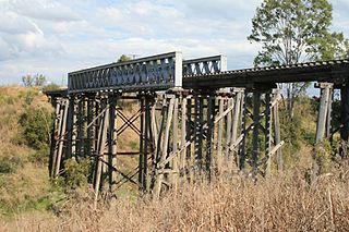
The Main Line is a railway line in South East Queensland, Australia. It was opened in a series of sections between 1865 and 1867. It commences at Roma St Station in Brisbane and extends west 161 km to Toowoomba. It is the first narrow gauge main line constructed in the world. The section of the line from the end of Murphys Creek railway station to the Ruthven Street overbridge, Harlaxton is listed on the Queensland Heritage Register. The Murphys Creek Railway Complex, the Lockyer Creek Railway Bridge (Lockyer), the Lockyer Creek Railway Bridge and Swansons Rail Bridge are also heritage listed.

Thornton is a rural locality in the Lockyer Valley Region, Queensland, Australia. In the 2021 census, Thornton had a population of 214 people.

<span class="mw-page-title-main">Mulgowie, Queensland</span> Suburb of Lockyer Valley Region, Queensland, Australia

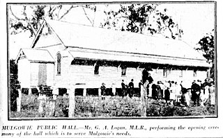
Mulgowie is a rural locality in the Lockyer Valley Region, Queensland, Australia. In the 2021 census, Mulgowie had a population of 166 people.

Summerholm is a rural locality in the Lockyer Valley Region, Queensland, Australia. In the 2021 census, Summerholm had a population of 646 people.

Townson is a rural locality in the Lockyer Valley Region, Queensland, Australia. In the 2021 census, Townson had a population of 52 people.

<span class="mw-page-title-main">Laidley Heights, Queensland</span> Suburb of Lockyer Valley Region, Queensland, Australia

Laidley Heights is a rural residential locality on the outskirts of the town of Laidley in the Lockyer Valley Region, Queensland, Australia. In the 2021 census, Laidley Heights had a population of 1,429 people.

<span class="mw-page-title-main">Laidley North, Queensland</span> Suburb of Lockyer Valley Region, Queensland, Australia

Laidley North is a rural locality in the Lockyer Valley Region, Queensland, Australia. In the 2021 census, Laidley North had a population of 593 people.

Laidley South is a rural locality in the Lockyer Valley Region, Queensland, Australia. In the 2021 census, Laidley South had a population of 293 people.

Mount Hallen is a rural locality in the Somerset Region, Queensland, Australia. In the 2021 census, Mount Hallen had a population of 457 people.

Netherby is a rural locality in the Fraser Coast Region, Queensland, Australia. In the 2021 census, Netherby had a population of 25 people.

Narko is a rural locality in the Toowoomba Region, Queensland, Australia. In the 2021 census, Narko had a population of 16 people.

References

  1. Kerr, J. 'Triumph of Narrow Gauge', Boolarong Publications 1990
  2. "LAIDLEY VALLEY LINE". The Brisbane Courier . No. 16, 621. Queensland, Australia. 20 April 1911. p. 5. Retrieved 22 April 2023 via National Library of Australia.
  3. 1 2 3 Bromby, Robin (2006). Ghost Railways of Australia. Sydney, Australia: Lothian Books. p. 10. ISBN   0734409230.
  4. "6 State Branch Railway lines To Be Closed". Townsville Daily Bulletin . Vol. LXXV. Queensland, Australia. 15 January 1955. p. 1. Retrieved 8 June 2024 via National Library of Australia.
  5. 1 2 3 4 5 6 "Queensland Two Mile series sheet 2m43" (Map). Queensland Government. 1953. Retrieved 22 April 2023.
  6. "Laidley – railway station in the Lockyer Valley Region (entry 18798)". Queensland Place Names. Queensland Government . Retrieved 7 October 2023.
  7. "Coopers Hill – rail station - feature no longer exists in Lockyer Valley Regional (entry 39245)". Queensland Place Names. Queensland Government . Retrieved 1 October 2023.
  8. "Goothenda – rail station - feature no longer exists in Lockyer Valley Regional (entry 39261)". Queensland Place Names. Queensland Government . Retrieved 1 October 2023.
  9. "Paree – rail station - feature no longer exists in Lockyer Valley Regional (entry 39310)". Queensland Place Names. Queensland Government . Retrieved 1 October 2023.
  10. "Kullee – rail station - feature no longer exists in Lockyer Valley Regional (entry 39698)". Queensland Place Names. Queensland Government . Retrieved 1 October 2023.
  11. "Queensland Two Mile series sheet 2m43" (Map). Queensland Government. 1942. Retrieved 7 October 2023.