
Bundaberg is a city in the Bundaberg Region, Queensland, Australia. It is the headquarters of the Bundaberg Regional Council and a major centre within the broader Wide Bay–Burnett geographical region.

The North Coast railway line is a 1,681-kilometre (1,045 mi) 3-foot 6-inch gauge railway line in Queensland, Australia. It commences at Roma Street station, Brisbane, and largely parallels the Queensland coast to Cairns in Far North Queensland. The line is electrified between Brisbane and Rockhampton. Along the way, the 1680 km railway passes through the numerous towns and cities of eastern Queensland including Nambour, Bundaberg, Gladstone, Rockhampton, Mackay and Townsville. The line though the centre of Rockhampton runs down the middle of Denison Street.
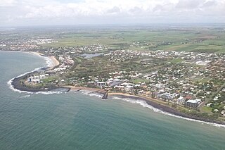
Bargara is a coastal town and suburb in the Bundaberg Region, Queensland, Australia. In the 2016 census the suburb of Bargara had a population of 7,485 people.
The City of Bundaberg was a local government area located in the Wide Bay–Burnett region of Queensland, Australia, encompassing the centre and inner suburbs of the regional city of Bundaberg. The city covered an area of 95.5 square kilometres (36.9 sq mi), and existed as a local government entity in various forms from 1881 until 2008, when it amalgamated with several other councils in the surrounding area to form the Bundaberg Region.

Innes Park is a coastal town and locality in the Bundaberg Region, Queensland, Australia. The town is 360 kilometres (224 mi) north of the state capital, Brisbane. At the 2016 census, Innes Park had a population of 2302.

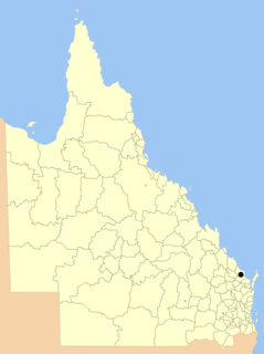
The Bundaberg Region is a local government area in the Wide Bay–Burnett region of Queensland, Australia, about 360 kilometres (220 mi) north of Brisbane, the state capital. It is centred on the city of Bundaberg, and also contains a significant rural area surrounding the city. It was created in 2008 from a merger of the City of Bundaberg with the Shires of Burnett, Isis and Kolan.

Wallaville is a rural town and locality in the Bundaberg Region, Queensland, Australia. It is 372 kilometres (231 mi) north of the state capital, Brisbane and 43 kilometres (27 mi) south west of the regional centre of Bundaberg. In the 2016 census, Wallaville had a population of 410 people.
The Shire of Woongarra was a local government area located to the south and east of the regional city of Bundaberg. The shire, administered from Bundaberg itself, covered an area of 722.4 square kilometres (278.9 sq mi), and existed as a local government entity from 1885 until 1994, when it amalgamated with Gooburrum to form the Shire of Burnett.
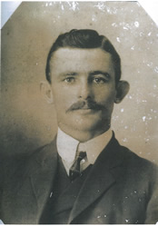
Frederick Lancelot Nott was a politician in Queensland, Australia and a Member of the Queensland Legislative Assembly from 1920 to 1927.
The Wallaville Branch Railway was a fifty kilometre railway line in Queensland, Australia. It was a branch line from Goondoon railway station southwest to Kalliwa Creek. It was approved in December 1914 to tap the Goodnight Scrub forests and to transport sugar cane to the Wallaville mill established in 1896.
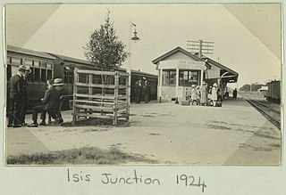
The Isis Branch Railway Line was a narrow gauge railway line in Queensland, Australia. It was approved for construction by the Parliament of Queensland in September, 1885. The North Coast line north from Brisbane, reached Maryborough in August 1881, Howard in March 1883 and Goodwood, to the south of Bundaberg, in August 1887.

The Mount Perry Branch Railway is a closed railway line in Central Queensland, Australia. In 1869 copper was discovered at Mount Perry and the township grew rapidly. A railway to the coast was essential to provide cheap transport and make the mining of low percentage ore viable. Maryborough and Bundaberg vied for the opportunity to be the terminus and the latter city was successful.
Frederick Courtice was a member of the Queensland Legislative Council.
Moreton Central Sugar Mill Cane Tramway is a heritage-listed tramway at Mill Street, Currie Street, and Howard Street, in Nambour, Sunshine Coast Region, Queensland, Australia. It was built c. 1897. It was added to the Queensland Heritage Register on 7 February 2005.

South Sea Islander Wall is a heritage-listed plantation at Grange Road, Mon Repos, Bundaberg Region, Queensland, Australia. It was built circa 1884 by South Sea Islander labour. It was added to the Queensland Heritage Register on 1 October 2001.

Mon Repos is a coastal locality in the Bundaberg Region, Queensland, Australia. In the 2016 census Mon Repos had a population of 30 people.

Bourbong Street Weeping Figs is a heritage-listed group of trees at Bourbong Street, Bundaberg Central, Bundaberg, Bundaberg Region, Queensland, Australia. They were added to the Queensland Heritage Register on 23 July 1999.

Saltwater Creek Railway Bridge is a heritage-listed railway bridge over Bundaberg Creek on Quay Street from Bundaberg Central to Bundaberg East in Bundaberg, Bundaberg Region, Queensland, Australia. It was built in 1894 by James Overend. It is also known as Millaquin Bridge. It was added to the Queensland Heritage Register on 21 October 1992.

Sir Anthony's Rest is a heritage-listed dry-stone lookout at Sir Anthony's Rest Street, Qunaba, Bundaberg Region, Queensland, Australia. It was built for the official visit of the Governor of Queensland, Sir Anthony Musgrave, to Bundaberg in his 1888 tour of the area. It is located on the summit of the Bundaberg Hummock hill and provides a commanding view of the surrounding Bargara canefields.
Bundaberg Sugar is a company involved in all aspects of sugar manufacture, including growing and milling the sugarcane and refining and marketing the sugar. It operates principally in the Bundaberg Region, Queensland, Australia. As at 2014, the company had over 9,000 hectares of sugarcane plantations.
