
The Ipswich and Rosewood line refers to the section of the Main Line to Toowoomba that has a regular suburban rail service, extending southwest from the Brisbane central business district. It is part of the Queensland Rail City network.

The Cleveland railway line is a suburban railway line extending 37.3 kilometres (23.2 mi) east-southeast from Brisbane, the state capital of Queensland, Australia. It is part of the Queensland Rail City network.

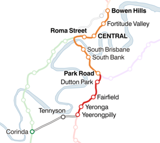
South Brisbane railway station is a heritage-listed railway station at 133 Grey Street, South Brisbane, City of Brisbane, Queensland, Australia. It is one of two stations serving the South Brisbane area, the other being South Bank. It was built from 1891 to 1918, making it the second oldest railway station in central Brisbane. It is also known as Cultural Centre Station, Melbourne Street Station, and South Brisbane (Interstate) Station. It was added to the Queensland Heritage Register on 21 October 1992.
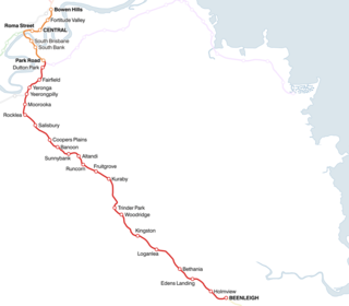
The Beenleigh railway line is a suburban railway line extending 40.1 km (24.9 mi) east-southeast from Brisbane Central railway station, the state capital of Queensland, Australia. It is part of the Queensland Rail City network.

Dutton Park is an inner southern suburb of the City of Brisbane, Queensland, Australia. In the 2016 census, Dutton Park had a population of 2,024 people.

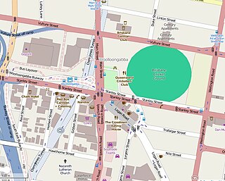
Woolloongabba is a suburb of the City of Brisbane, Queensland, Australia. It is located 2 kilometres (1.2 mi) south-east of the CBD, and contains the Brisbane Cricket Ground and the Princess Alexandra Hospital. It is crossed by several major roads including the Pacific Motorway, Logan Road and Ipswich Road. The suburb was once home to a large tram depot.
The Corinda–Yeerongpilly line is a railway line in Brisbane, the state capital of Queensland, Australia. It connects the Beenleigh and Ipswich lines for freight trains, but is no longer a passenger service.

The Brisbane tramway network served the city of Brisbane, Australia, between 1885 and 1969. It ran on standard gauge track. The electric system was originally energised to 500 volts, and subsequently increased to 600 volts. All tramcars built in Brisbane up to 1938 had an open design. This proved so popular, especially on hot summer nights, that the trams were used as fundraisers and often chartered right up until the last service by social groups.

Brisbane, the capital city of the Australian state of Queensland, has a network of suburban railways that carry commuters, long-distance passengers, and freight. Suburban and interurban passenger services in Brisbane and South East Queensland are operated by the Queensland Rail City network, a branch of Queensland Rail, which operates long-distance trains across the state. Aurizon and Pacific National operate freight services.

Plymouth Friary railway station was the London and South Western Railway (LSWR) terminus in Plymouth, Devon, England.
Queensland Rail operates ten suburban lines and three interurban lines. Centring in the Brisbane City, it extends as far as Gympie in the north, Varsity Lakes in the south, Rosewood in the west, and Cleveland in the east to Moreton Bay.
Cross River Rail is an underground railway project through central Brisbane, which is currently under construction. Cross River Rail will see the development of a new rail line underneath Brisbane River, and the redevelopment of a number of stations in the Brisbane central business district. The business case for the project was released in August 2017, with work officially beginning in September. The project replaces the planned 2013 BaT Tunnel, which in turn had replaced the original 2010 Cross River Rail proposal.
The South Brisbane Railway Easement is the heritage-listed remnants of a former railway branch line and siding at 412 Stanley Street, South Brisbane, Queensland, Australia. It was built from 1882 to 1897. It is also known as Dry Dock Siding, South Brisbane Wharves Extension, and Stanley Street Terminus. It was added to the Queensland Heritage Register on 21 October 1992.
Woolloongaba Post Office is a heritage-listed former post office at 765 Stanley Street, Woolloongabba, City of Brisbane, Queensland, Australia. It was designed by Thomas Pye and built in 1905 by Thomas Rees. It is also known as Woolloongabba Post & Telegraph Office. It was added to the Queensland Heritage Register on 24 January 2003.

Taylor–Heaslop Building is a heritage-listed commercial building at 10-14 Logan Road, Woolloongabba, City of Brisbane, Queensland, Australia. It was designed by John Beauchamp Nicholson and built from 1889 to 1890. It is also known as Ernest Reid (draper), John Evan's Cash Draper, George Logan Draper, Johns & Co Draper, People's Cash Store (grocers), JR Blane, and Moreton Rubber Works. It was added to the Queensland Heritage Register on 6 February 2006.
The Woolloongabba Fiveways is the intersection of 5 major roads at Woolloongabba, Brisbane, Queensland, Australia. The intersection gives its name to the surrounding commercial area.

Maryborough railway station is a heritage-listed railway station at Lennox Street, Maryborough, Fraser Coast Region, Queensland, Australia. It is on the North Coast line serving the city of Maryborough. It was designed by Chief Engineer of the Queensland Railways Department and built from 1878 to 1890 by John Roddam & John Walker. It was added to the Queensland Heritage Register on 21 October 1992.

Wallangarra railway station is a heritage-listed railway station at Woodlawn Street, Wallangarra, Southern Downs Region, Queensland, Australia. It was built in 1877 along the state border of Queensland and New South Wales It was added to the Queensland Heritage Register on 28 March 2003.
The BaT project was a proposed north-south tunnel that would provide bus and rail modes of transportation together in an intuitive design by combining a new underground rail line and busway in a single, double-decked, 15m-wide tunnel beneath the Brisbane River and Brisbane central business district. The tunnel was to have three underground stations at Woolloongabba, George Street and Roma Street with Dutton Park upgraded.

