Logan Road, Brisbane

Last updated

Logan Road
Queensland
Logan Road, Greenslopes, with Brisbane CBD.jpg
View along Logan Road at Greenslopes
General information
Type Road
Length 18 km (11 mi)
Route number(s)
  • Australian state route 95.svg State Route 95 (Woolloongabba to Underwood)
  • Australian state route 30.svg State Route 30 (Underwood to Pacific Motorway)
Major junctions
North endAustralian state route 95.svg Wellington Road (State Route 95), Woolloongabba
 
  • Australian state route 22.svg Old Cleveland Road (State Route 22)
  • Australian state route 10.svg Marshall Road / Holland Road (State Route 10)
  • Australian state route 20.svg Creek Road (State Route 20)
  • AUS Metroad 2.svg Kessels Road / Mount Gravatt Capalaba Road (Metroad 2)
  • Australian state route 41.svg Newnham Road (State Route 41)
  • AUS Alphanumeric Route M3.svg Pacific Motorway ((M3)
  • Australian state route 56.svg Padstow Road / Miles Platting Road (State Route 56)
  • AUS Alphanumeric Route M2.svg Gateway Motorway ((M2)
  • Australian state route 57.svg Beenleigh Road (State Route 57)
  • Australian state route 95.svg Kingston Road (State Route 95)
  • Australian state route 30.svg Compton Road (State Route 30)
  • AUS Alphanumeric Route M3.svg Pacific Motorway ((M3)
South endAustralian state route 30.svg Rochedale Road (State Route 30), Springwood
Location(s)
Major suburbs Greenslopes, Holland Park, Mount Gravatt, Underwood

Logan Road, allocated state routes 95 and 30, is a major road in Brisbane, Queensland. It runs 18 kilometres (11 mi) from Springwood in Logan City to Woolloongabba in Brisbane, with most of the route signed as state route 95. The route was formerly the main route to the Gold Coast from Brisbane, until the South East Freeway (now Pacific Motorway) was built.

Brisbane capital city of Queensland, Australia

Brisbane is the capital of and the most populated city in the Australian state of Queensland, and the third most populous city in Australia. Brisbane's metropolitan area has a population of 2.5 million, and the South East Queensland region, centred on Brisbane, encompasses a population of more than 3.5 million. The Brisbane central business district stands on the historic European settlement and is situated inside a peninsula of the Brisbane River, about 15 kilometres from its mouth at Moreton Bay. The metropolitan area extends in all directions along the floodplain of the Brisbane River Valley between Moreton Bay and the Great Dividing Range, sprawling across several of Australia's most populous local government areas (LGAs)—most centrally the City of Brisbane, which is by far the most populous LGA in the nation. The demonym of Brisbane is "Brisbanite" or "Brisbanian".

Queensland North-east state of Australia

Queensland is the second-largest and third-most populous state in the Commonwealth of Australia. Situated in the north-east of the country, it is bordered by the Northern Territory, South Australia and New South Wales to the west, south-west and south respectively. To the east, Queensland is bordered by the Coral Sea and Pacific Ocean. To its north is the Torres Strait, with Papua New Guinea located less than 200 km across it from the mainland. The state is the world's sixth-largest sub-national entity, with an area of 1,852,642 square kilometres (715,309 sq mi).

Springwood, Queensland Suburb of Logan City, Queensland, Australia

Springwood is a suburb of Logan City, Queensland, Australia. The size of Springwood is approximately 6 km². It has 17 parks covering nearly 9% of the total area. The population of Springwood in 1996 was 9,738 people. By 2001 the population was 9,084 showing a population decline of 7% in the area during that time. A high proportion of people in Springwood are in the baby boomers generation compared to population proportions in the surrounding local government area.

Contents

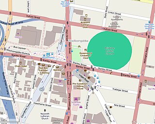
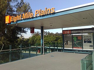
The road runs close to the Gabba and Greenslopes Private Hospital, Mount Gravatt, past Westfield Garden City and the Upper Mount Gravatt busway station. Logan Road provides the quickest access to Mount Gravatt from the south, as well as being the main access road for the Westfield Garden City Shopping Centre. At the road's southern extent it is crossed by both the Pacific Motorway and Gateway Motorway. At Underwood Kingston Road splits off to become a major road into central Logan City.

The Gabba stadium in Brisbane, Queensland, Australia

The Brisbane Cricket Ground, commonly known as the Gabba, is a major sports stadium in Brisbane, the capital of Queensland, Australia. The nickname Gabba derives from the suburb of Woolloongabba, in which it is located.

Greenslopes Private Hospital Hospital in Queensland, Australia

Greenslopes Private Hospital is a private health care provider located in Greenslopes, Brisbane, Australia. It was named Australia's Best Private Hospital, 1999 and received the Australian Private Hospitals Association's, Hospital Quality of Excellence Award, 2004.

Westfield Garden City, better known as Garden City, is one of Brisbane's major shopping centres, located in the suburb of Upper Mount Gravatt. The centre is operated by Westfield, and previously operated by AMP Limited before the takeover in 2003. The shopping centre currently has 470 specialty stores, cafes, restaurants and other services and food vendors.

History

Logan Road at Mount Gravatt Central. Mount Gravatt Central.jpg
Logan Road at Mount Gravatt Central.

William Slack, a local cattle grazier, took his stock along a possible Aboriginal track which became known to the locals as Slacks Track. [1] Later the track became a road and then highway.

The route takes its name from Captain Patrick Logan, one of the founders of the Moreton Bay convict settlement. Its route is similar to that of the Pacific Motorway and can be accessed directly via exit numbers 20 and 14 as well as by the Gateway Motorway.

Patrick Logan British Army officer

Captain Patrick Logan was the commandant of the Moreton Bay Penal Settlement from 1826 until his death in 1830 at the hands of Aboriginal Australians who objected to him entering their lands. As he had been hated by convicts, there were rumours that escaped convicts living in the bush had attacked him, but there is no evidence of this.

Moreton Bay bay in Queensland, Australia

The Moreton Bay is a bay located on the eastern coast of Australia 14 kilometres (8.7 mi) from central Brisbane, Queensland. It is one of Queensland's most important coastal resources. The waters of Moreton Bay are a popular destination for recreational anglers and are used by commercial operators who provide seafood to market.

The Gateway Motorway is a major tolled motorway in Brisbane, Queensland, Australia which includes the Sir Leo Hielscher Bridges. The motorway is operated by toll road operator Transurban.

The first electric trams travelled along the road in 1897. [2] Between 1953 and 1969, electric trams ran along Logan Road between Woolloongabba and Mount Gravatt.

Trams in Brisbane

The Brisbane tramway network served the city of Brisbane, Australia, between 1885 and 1969. It ran on standard gauge track. The electric system was originally energised to 500 volts, and subsequently increased to 600 volts. All tramcars built in Brisbane up to 1938 had an open design. This proved so popular, especially on hot summer nights, that the trams were used as fundraisers and often chartered right up until the last service by social groups.

Woolloongabba Suburb of Brisbane, Queensland, Australia

Woolloongabba is a suburb of Brisbane, Australia. It is located 2 kilometres (1.2 mi) south-east of the CBD, and contains the Brisbane Cricket Ground and the Princess Alexandra Hospital. It is crossed by several major roads including the Pacific Motorway. The suburb was once home to a large tram depot.

Mount Gravatt, Queensland Suburb of Brisbane, Queensland, Australia

Mount Gravatt is the name of both a major suburb of Brisbane, Queensland, Australia and a prominent hill in this suburb. The suburb is situated in the south-east of the city and was one of Brisbane's largest. This was before it was divided into Mount Gravatt East, Upper Mount Gravatt and Mount Gravatt South; the last being changed to Wishart in the early 1990s. At the 2016 Australian Census, the suburb recorded a population of 3,366.

At the northern end of Logan Road is the Woolloongabba Fiveways. This intersection was one of the busiest in the city, requiring a policeman to coordinate rail and road traffic. [3]

Woolloongabba Fiveways

The Woolloongabba Fiveways is the intersection of 5 major roads at Woolloongabba, Brisbane, Queensland, Australia. The intersection gives its name to the surrounding commercial area.

Major intersections

The road is in the Brisbane local government area, except the last 3.3 kilometres, which are in Logan City.

LocationkmmiDestinationsNotes
Woolloongabba 00.0Dead end - no adjoining roads or streetsNorth-west end of Logan Road (no route number)
No vehicle access between Logan Road and the Main Street / Ipswich Road / Stanley Street intersection at this location.
0.50.31Australian state route 95.svg - Wellington Road (State Route 95) - north - East Brisbane
Balaclava Street - west - Ipswich Road
Southbound traffic on Logan Road meets Wellington Road at a T junction, with no right turn towards the continuation of Logan Road.
Thus traffic wishing to continue south on Logan Road must approach this intersection from one of the side streets.
Logan Road continues south as State Route 95.
Woolloongabba /
Greenslopes boundary
1.40.87Okeefe Street - west - Ipswich RoadNorth-western concurrency terminus with State Route 22.
Logan Road continues south-east as State Route 95, concurrent with State Route 22.
Greenslopes 1.71.1Australian state route 22.svg Old Cleveland Road (State Route 22) - east - Coorparoo Logan Road continues south-east with no route number.
State Route 95 continues east on Old Cleveland Road, and then south on Montague Street to rejoin Logan Road.
1.71.1South-eastern concurrency terminus with State Route 22.
2.01.2Australian state route 95.svg Montague Street (State Route 95) - north - Old Cleveland RoadLogan Road continues south-east as State Route 95.
Holland Park /
Holland Park West boundary
4.93.0Australian state route 10.svg Marshall Road (State Route 10) - south-west - Holland Park West
Australian state route 10.svg Holland Road (State Route 10) - north-east - Holland Park
Mount Gravatt /
Mount Gravatt East boundary
7.54.7Australian state route 20.svg Creek Road (State Route 20) - north-east - Mount Gravatt East
Upper Mount Gravatt 10.06.2AUS Metroad 2.svg Kessels Road (Metroad 2) - south-west - MacGregor
AUS Metroad 2.svg Mount Gravatt Capalaba Road (Metroad 2) - north-east - Wishart
Upper Mount Gravatt /
Wishart boundary
11.06.8Australian state route 41.svg Newnham Road (State Route 41) - north - Wishart
Eight Mile Plains 11.47.1AUS Alphanumeric Route M3.svg Pacific Motorway (M3) - north-west - MacGregor /
south-east - Eight Mile Plains
12.17.5Australian state route 56.svg Padstow Road (State Route 56) - west - Sunnybank /
Australian state route 56.svg Miles Platting Road (State Route 56) - east - Rochedale
13.48.3AUS Alphanumeric Route M2.svg Gateway Motorway (M2) - south-west - Runcorn, Kuraby /
north-east - Mackenzie
No exit to Gateway Motorway northbound (see next intersection)
13.78.5Levington Road - south-west - Kuraby /
north-east - Gateway Motorway
Provides an exit to Gateway Motorway northbound
Eight Mile Plains /
Underwood border
14.79.1Underwood Road - west - Runcorn /
east - Rochedale South
Underwood Road is the boundary between the City of Brisbane and Logan City local government areas at this point.
Logan Road (State Route 95) continues south into Logan City.
Underwood, Rochedale South, Slacks Creek, Woodridge, and Springwood
(mentioned in this and/or subsequent intersections) are in Logan City.
Underwood 16.110.0Australian state route 57.svg Beenleigh Road (State Route 57) - west - Kuraby
16.410.2Australian state route 95.svg Kingston Road (State Route 95) - south - Slacks Creek, WoodridgeLogan Road continues south-east with no route number
Underwood /
Slacks Creek boundary
17.610.9Australian state route 30.svg Compton Road (State Route 30) - south-west - WoodridgeLogan Road continues south-east as State Route 30
Underwood /
Slacks Creek /
Springwood boundary
17.911.1AUS Alphanumeric Route M3.svg Pacific Motorway (M3) - north - Underwood, Rochedale South /
south - Springwood, Slacks Creek
Springwood 18.011.2Australian state route 30.svg Rochedale Road (State Route 30) - north - Rochedale South /
Pacific Highway Service Road - south - Springwood /
Fitzgerald Avenue - north-east - Springwood
South-east end of Logan Road.
1.000 mi = 1.609 km; 1.000 km = 0.621 mi

See also

Related Research Articles

Metroads were the primary road routes serving the Sydney and Brisbane metropolitan areas from the 1990s to the 2010s. The Metroads formed a network of radial and circumferential routes throughout the cities, simplifying navigation. Metroads have been progressively phased out in both Sydney and Brisbane, replaced by alphanumeric route numbers. Brisbane is the only city currently retaining the Metroad system.

South East Busway bus-only road in Queensland, Australia

The South East Busway is a grade separated bus-only road running south from the Brisbane central business district to Eight Mile Plains in Queensland, Australia. The busway was completed to Woolloongabba in September 2000 and to Eight Mile Plains in April 2001. An extension of the busway to School Road at Rochedale was completed in 2014.

Logan Motorway motorway in Brisbane

The M2/M6 Logan Motorway is a 30-kilometre toll road between Ipswich and the M1 or Pacific Motorway at Loganholme, and the Gateway Motorway, providing access to the Gold Coast on the eastern seaboard and to the rural areas of the Darling Downs to the west. The M6 portion runs from the Pacific Motorway to the junction with the Gateway extension where it then becomes the M2

Carindale, Queensland Suburb of Brisbane, Queensland, Australia

Carindale is a suburb of Brisbane, Queensland, Australia. It is located 10 kilometres (6.2 mi) east of the CBD, and borders Belmont, Carina, Carina Heights, Mackenzie, Mansfield, Mount Gravatt East, and Tingalpa.

Upper Mount Gravatt, Queensland Suburb of Brisbane, Queensland, Australia

Upper Mount Gravatt is a suburb in the City of Brisbane, Queensland, Australia.

Mackenzie, Queensland Suburb of Brisbane City, Queensland, Australia

Mackenzie is a small suburb located in the south-east of Brisbane, Queensland, Australia. In the 2011 census, Mackenzie had a population of 1,844 people.

Eight Mile Plains busway station

Eight Mile Plains busway station is the southern most station on the South East Busway in Brisbane, Australia serving the suburb of Eight Mile Plains. It opened on 30 April 2001 when the busway was extended from Woolloongabba.

Upper Mount Gravatt busway station

Upper Mount Gravatt busway station is located in Brisbane, Australia serving the suburb of Upper Mount Gravatt. It opened on 30 April 2001 when the South East Busway was extended from Woolloongabba to Eight Mile Plains.

The M1 in Brisbane, Queensland, Australia, is a major urban road corridor. It connects the Sunshine Coast hinterland to Tugun, near the New South Wales-Queensland border, via the following corridors:

Transport in Brisbane

Transport in Brisbane, the capital and largest city of Queensland, Australia, is provided by road, rail, river and bay ferries, footpaths, bikepaths, sea and air.

Ipswich Road, Brisbane road in Brisbane

Ipswich Road is one Brisbane's main roads connecting Brisbane to the nearby city of Ipswich, via the Ipswich Motorway. Ipswich Road used to be part of the Cunningham Highway. Logan Road, Pacific Motorway, and Beaudesert Road are the other major roads in the south of Brisbane. The road was an important transport route in 19th century Brisbane.

Road transport in Brisbane Wikimedia list article

The road transport of Brisbane, Australia consists of a network of highways, freeways and motorways. Some motorways have tolls applied.

The M7/A7 in Brisbane, Queensland, Australia, is a major urban road corridor. It extends from the M2/M7 Ipswich Motorway/Logan Motorway junction at Gailes via Ipswich Road at Woolloongabba, Clem Jones Tunnel and Airport Link to the junction with Southern Cross Way which links with the Gateway Motorway.

Old Cleveland Road, Brisbane road in Brisbane

Old Cleveland Road is a major road in Brisbane, Queensland. It runs 19.3 kilometres (12.0 mi) from Stones Corner to Capalaba in Brisbane, with most of the route signed as State Route 22. Sections of the road are also part of State Routes 30, 54, and 55. The road is the main route from inner Brisbane to Capalaba and Cleveland since New Cleveland Road only links Tingalpa with Capalaba.

Old Cleveland Road Tramway Tracks

Old Cleveland Road Tramway Tracks is a heritage-listed tramway at Old Cleveland Road, Carina, City of Brisbane, Queensland, Australia. It was built in 1948 by Brisbane City Council. It is also known as Belmont Electric Tramway. It was added to the Queensland Heritage Register on 24 March 2000.

References

  1. Roberts, Beryl (1991). Stories of the Southside. Archerfield, Queensland: Aussie Books. p. 47. ISBN   0-947336-01-X.
  2. J.E.Morwood (28 February 1970). "History Of Electric Tramways In Brisbane". Brisbane Tramway Museum Society. Retrieved 5 February 2013.
  3. "Local history: Woolloongabba". State Library of Queensland. 6 May 2009. Retrieved 18 April 2015.

Commons-logo.svg Media related to Logan Road, Brisbane at Wikimedia Commons

Coordinates: 27°30′18.44″S153°02′54.36″E / 27.5051222°S 153.0484333°E / -27.5051222; 153.0484333