
The Pacific Highway is a 790-kilometre-long (490 mi) national highway and major transport route along the central east coast of Australia, with the majority of it being part of Australia's national route 1.

The Princes Motorway is a 55-kilometre (34 mi) predominately dual carriage untolled motorway that links Sydney to Wollongong and further south through the Illawarra region to Albion Park Rail. Part of the Australian Highway 1 network, the motorway is designated with the route number M1.
Mitchell Freeway is a 30-kilometre-long (19 mi) freeway in the northern suburbs of Perth, Western Australia, linking central Perth with the satellite city of Joondalup. It is the northern section of State Route 2, which continues south as Kwinana Freeway and Forrest Highway. Along its length are interchanges with several major roads, including Graham Farmer Freeway and Reid Highway. The southern terminus of the Mitchell Freeway is at the Narrows Bridge, which crosses the Swan River, and the northern terminus is at Hester Avenue, Clarkson, a suburb within the City of Wanneroo.

The M1 Pacific Motorway, also known by the former names F3 Freeway, Sydney–Newcastle Freeway, and Sydney–Newcastle Expressway; is a 127 km (79 mi) stretch of freeway linking Sydney to the Central Coast, Newcastle and Hunter regions of New South Wales. It is part of the AusLink road corridor between Sydney and Brisbane. The name "F3 Freeway", reflects its former route allocation, but is commonly used by both the public and the government to refer to the roadway long after the route allocation itself was no longer in use.
The Gateway Motorway is a major tolled motorway in Brisbane, Queensland, Australia which includes the Sir Leo Hielscher Bridges. The motorway is operated by toll road operator Transurban.

The Warringah Freeway is a 3-kilometre (1.9 mi) divided freeway located in Sydney, New South Wales, Australia. The freeway forms part of the M1, the Sydney Orbital Network, and the Highway 1 network. The primary function of the freeway is to provide an alternative high-grade route from the Sydney Harbour Tunnel and the Bradfield Highway at Milsons Point to the A8 and the Gore Hill Freeway. The freeway reduces traffic demands on the Pacific Highway throughout Sydney's lower north shore, bypassing North Sydney and Crows Nest. Completed in a series of stages between June 1968 and August 1992, the Warringah Freeway provides a vital link to access most of the suburbs in Sydney and is also a major route to the north, south, east and west of the central business district.

The South Coast railway line was an Australian railway from Brisbane, the capital city of Queensland, to the Gold Coast. It operated from 1889 to 1964. The Gold Coast railway line re-opened in 1996 along a modified alignment in the north and a new route south.

G:link, also known as the Gold Coast Light Rail, is a light rail system serving the Gold Coast in Queensland, Australia. The system forms part of the TransLink's South East Queensland public transport network and consists of a single 20-kilometre (12 mi) line of nineteen stations. Helensvale railway station is the northern terminus of the system, while Broadbeach South is the southern terminus. The line opened on 20 July 2014 and was extended northwest from Gold Coast University Hospital to Helensvale on 17 December 2017.

The Gold Coast is the largest regional city and fastest growing city in Australia. As a result, the Gold Coast has a wide range of public and private transport options from cars and bikes to buses, heavy rail and light rail. The car is the dominant mode of transport in the city with an extensive arterial road network that connects the standard residential streets with major suburbs and motorways.

The road transport of Brisbane, Australia consists of a network of highways, freeways and motorways. Some motorways have tolls applied.
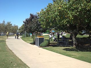
The Southport Broadwater Parklands is a large community park located in Southport. It is designed for large community gatherings and families. The park has many different areas for children and barbecue areas for families. The park went through a major redevelopment and was re-opened by the Premier of Queensland, Anna Bligh, on 23 August 2009. Southport Broadwater Parklands has become a popular family attraction.
This is a list of freeways in Australia, sorted by states and territories and their corresponding routes. This list includes tollways / toll roads such as the CityLink freeway system in Melbourne. This list has over 70 entries. The only jurisdiction in Australia without freeways is the Northern Territory. Victoria has the largest and densest freeway network in Australia.
Bermuda Street is a road on the Gold Coast from Bundall to Burleigh Heads in Queensland, Australia. Originally a suburban street, it is now part of Southport – Burleigh Road, a state controlled road
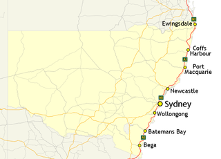
In New South Wales, Highway 1 is a 1,351-kilometre (839 mi) long route that crosses the state, from the Queensland/New South Wales border near Tweed Heads to the Victorian border near Timbillica. It provides the main coastal route between Brisbane and Melbourne via Sydney. Highway 1 continues around the rest of Australia, joining all mainland state capitals, and connecting major centres in Tasmania.

The Gold Coast central business district (CBD) is the planned main commercial centre of the Gold Coast, Queensland, Australia. The area encompasses an eastern portion of the Southport suburb. Its north–south axis runs from North Street in the north to Brighton Parade in the south. Its east–west axis runs from Broadwater in the east to the High Street in the west.
The Gold Coast Private Hospital is a private hospital facility in Southport, Gold Coast that replaced Allamanda Private Hospital from March 12, 2016. The $230 million facility opened with 284 beds and 13 operating theatres with capacity to expand to 400 beds and 21 theatres, in line with demand.
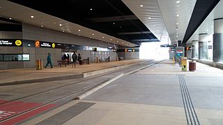
Gold Coast University Hospital light rail station is a major public transport interchange, providing an important bus - light rail interchange for the Gold Coast suburb of Southport. GCUH is part of the Gold Coast's G:link light rail network and was the original northern terminus of the G:link until an extension was completed to Helensvale in 2017. The Gold Coast University Hospital station is the only underground light rail station for network and provides a bus interchange located on the street level.


