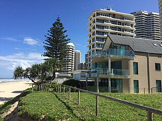
Molendinar, Queensland

Last updated

Map all coordinates using: OpenStreetMap
Molendinar
Gold Coast,  Queensland
Ernest Junction railway tunnel, eastern portal, 2019.jpg
Ernest Junction railway tunnel, eastern portal, 2019
Gold Coast locator map.svg
Red pog.svg
Molendinar
Coordinates 27°58′25″S153°21′41″E / 27.9736°S 153.3613°E / -27.9736; 153.3613 (Molendinar (centre of suburb))
Population6,375 (2016 census) [1]
 • Density828/km2 (2,144/sq mi)
Postcode(s) 4214
Area7.7 km2 (3.0 sq mi)
Time zone AEST (UTC+10:00)
Location
LGA(s) City of Gold Coast
State electorate(s) Southport
Federal division(s) Moncrieff
Suburbs around Molendinar:
Arundel Parkwood Southport
Gaven Molendinar Southport
Nerang Ashmore Ashmore

Molendinar is a mixed-use suburb in the City of Gold Coast, Queensland, Australia. [2] In the 2016 census, Molendinar had a population of 6,375 people. [1]

Contents

Geography

The suburb is bounded by Smith Street to the north, Olsen Avenue to the east, the Southport Nerang Road to the south and Pacific Motorway to the west. [3]

The land use is a mixture of residential areas and industrial areas. [3]

History

Jerringan is the Aboriginal name for the area meaning stringybark tree. [4]

The suburb takes its name from the former Molendinar railway station ( 27°59′08″S153°21′22″E / 27.9855°S 153.3560°E / -27.9855; 153.3560 (Molendinar railway station (former)) ) [5] on the South Coast railway line (opened in 1889 and closed in 1964). The railway station in turn was named after a farm selected by George Hope named after Molendinar Burn, a stream which once flowed through central Glasgow in Scotland. [2] [6] Ernest Junction railway station ( 27°58′12″S153°21′32″E / 27.9701°S 153.3588°E / -27.9701; 153.3588 (Ernest Junction railway station (former)) ) was another former railway station on the South Coast line in the north of the present-day suburb. [7]

The area was known as Silver Bridle in the 1960s.[ citation needed ] Molendinar incorporated a previous suburb known as Ernest on its northern range until 2003 when it was separated and renamed as Parkwood. [8]

The Molendinar Industrial Estate was a Queensland Government project supported by the Gold Coast City Council which commenced development beginning in 1969. [9]

Trinity Lutheran Primary School opened at Cotlew Street, Ashmore, on 27 January 1981. [10]

Trinity Lutheran College (a secondary school) opened on 28 January 1987 as Ashmore Road in Molendinar. [10]

In 2002 the two Lutheran schools merged to form Trinity Lutheran College (a primary and secondary school) operating on two campuses at Cotlew Street in Ashmore and Ashmore Road in Molendinar. [10]

At the 2011 census, Molendinar had a population of 6,375. [11]

On 2 April 2012, an official dedication of the Lynne Richardson Community Centre was held by the Gold Coast City Council.[ citation needed ]

In the 2016 census, Molendinar had a population of 6,375 people. [1] The median age of people in Molendinar was 36 years. [1]

Heritage listings

Ernest Junction Railway Tunnel, west entrance, 2019 Ernest Junction Railway Tunnel, west entrance, 2019.jpg
Ernest Junction Railway Tunnel, west entrance, 2019

There are a number of heritage sites in Molendinar, including at 797 Ashmore Road ( 27°57′55″S153°21′21″E / 27.9654°S 153.3558°E / -27.9654; 153.3558 (Ernest Junction Railway Tunnel) ): Ernest Junction Railway Tunnel [12] [13] The tunnel is another remnant of the South Coast line. The tunnel has a length of 110 metres. [14]

Education

Trinity Lutheran College is a private primary and secondary school for boys and girls which operates its primary (Prep-5) campus at 641 Ashmore Road ( 27°58′45″S153°21′49″E / 27.9792°S 153.36354°E / -27.9792; 153.36354 (Trinity Lutheran College Prep-5 campus) ). [15] [16] In 2017, the school (both campuses combined) had an enrolment of 1,050 students with 85 teachers (76 full-time equivalent) and 62 non-teaching staff (35 full-time equivalent). [17]

There are no government schools in Molendinar. The nearest government primary school is Ashmore State School in neighbouring Ashmore or Nerang State School in Nerang. The nearest government secondary school is Keebra Park State High School in Southport or Nerang State High School in Nerang. [3]

Amenities

Lynne Richardson Community Centre is at 2A Gidgee Court ( 27°58′42″S153°22′20″E / 27.9782°S 153.3723°E / -27.9782; 153.3723 (Lynne Richardson Community Centre) ). [18]

Related Research Articles

<span class="mw-page-title-main">Surfers Paradise, Queensland</span> Town in Queensland, Australia

Surfers Paradise is a suburb in the City of Gold Coast, Queensland, Australia. In the 2021 census, Surfers Paradise had a population of 26,412 people.

<span class="mw-page-title-main">Bethania, Queensland</span> Suburb of Logan City, Queensland, Australia

Bethania is a suburb in the City of Logan, Queensland, Australia. In the 2016 census, Bethania had a population of 5,385 people.

<span class="mw-page-title-main">Broadbeach, Queensland</span> Suburb of Gold Coast, Queensland, Australia

Broadbeach is a suburb in the City of Gold Coast, Queensland, Australia. In the 2021 census, Broadbeach had a population of 6,786 people.

<span class="mw-page-title-main">Main Beach, Queensland</span> Suburb of Gold Coast, Queensland, Australia

Main Beach is a coastal town and suburb in the City of Gold Coast, Queensland, Australia. In the 2016 census, the suburb of Main Beach had a population of 3,883 people.

<span class="mw-page-title-main">Mudgeeraba, Queensland</span> Suburb of City of Gold Coast, Queensland, Australia

Mudgeeraba is a town and suburb in the City of Gold Coast, Queensland, Australia. In the 2016 census, the suburb of Mudgeeraba had a population of 13,624 people.

<span class="mw-page-title-main">Nerang, Queensland</span> Suburb of Gold Coast, Queensland, Australia

Nerang is a town and suburb in the City of Gold Coast, Queensland, Australia. In the 2016 census, Nerang had a population of 16,864 people.

<span class="mw-page-title-main">Southport, Queensland</span> Suburb of Gold Coast, Queensland, Australia

Southport is a coastal town and suburb in the City of Gold Coast in Queensland, Australia. It contains the Gold Coast central business district. In the 2021 census, Southport had a population of 36,786 people.

<span class="mw-page-title-main">Woolloongabba</span> Suburb of Brisbane, Queensland, Australia

Woolloongabba is a suburb in the City of Brisbane, Queensland, Australia. In the 2016 census, Woolloongabba had a population of 5,631 people.

<span class="mw-page-title-main">Carrara, Queensland</span> Suburb of Gold Coast, Queensland, Australia

Carrara is a suburb in the City of Gold Coast, Queensland, Australia. In the 2016 census, Carrara had a population of 12,060 people.

<span class="mw-page-title-main">Ashmore, Queensland</span> Suburb of Gold Coast, Queensland, Australia

Ashmore is a suburb of the City of Gold Coast, Queensland, Australia. In the 2016 census, Ashmore had a population of 11,910 people.

Benowa is a suburb in the City of Gold Coast, Queensland, Australia. In the 2016 census, Benowa had a population of 8,741 people.

<span class="mw-page-title-main">Bundall, Queensland</span> Suburb of Gold Coast, Queensland, Australia

Bundall is a suburb in the City of Gold Coast, Queensland, Australia. In the 2016 census, Bundall had a population of 4,523 people.

<span class="mw-page-title-main">South Coast railway line, Queensland</span>

The South Coast railway line was a railway from Brisbane, the capital city of Queensland, Australia. The route via the South Coast to Tweed Heads on the border of Queensland and New South Wales. The line operated from 1889 to 1964. The Gold Coast railway line re-opened in 1996 along a modified alignment in the north and a new route south but does not extend as far south yet as the South Coast line.

Pimpama is a northern suburb in the City of Gold Coast, Queensland, Australia. At the 2021 census, Pimpama had a population of 24,601. The name is of Aboriginal origin. The suburb contains numerous schools with the first opening in the 1870s.

<span class="mw-page-title-main">Clagiraba, Queensland</span> Suburb of Gold Coast, Queensland, Australia

Clagiraba is a rural locality in the City of Gold Coast, Queensland, Australia. In the 2021 census, Clagiraba had a population of 651 people.

<span class="mw-page-title-main">Advancetown, Queensland</span> Suburb of Gold Coast, Queensland, Australia

Advancetown is a rural outer locality in the City of Gold Coast, Queensland, Australia. In the 2016 census, Advancetown had a population of 482 people.

<span class="mw-page-title-main">Waterford, Queensland</span> Town in Queensland, Australia

Waterford is a town and suburb in the City of Logan, Queensland, Australia. In the 2016 census, the suburb of Waterford had a population of 5,484 people.

<span class="mw-page-title-main">Gilston, Queensland</span> Suburb of City of Gold Coast, Queensland, Australia

Gilston is a rural residential locality in the City of Gold Coast, Queensland, Australia. In the 2016 census, Gilston had a population of 2,459 people.

<span class="mw-page-title-main">Neranwood, Queensland</span> Suburb of City of Gold Coast, Queensland, Australia

Neranwood is a suburb in the City of Gold Coast, Queensland, Australia. In the 2016 census Neranwood had a population of 67 people.

<span class="mw-page-title-main">Ernest Junction railway tunnel</span> Historic site in Queensland, Australia

Ernest Junction railway tunnel is a heritage-listed former railway tunnel at 797 Ashmore Road, Molendinar, Gold Coast City, Queensland, Australia. It was built from 1885 to 1889 by the Queensland Railway Department. It was added to the Queensland Heritage Register on 3 May 2019.

References

  1. 1 2 3 4 Australian Bureau of Statistics (27 June 2017). "Molendinar (SSC)". 2016 Census QuickStats. Retrieved 20 October 2018. OOjs UI icon edit-ltr-progressive.svg
  2. 1 2 "Molendinar – suburb in City of Gold Coast (entry 46065)". Queensland Place Names. Queensland Government . Retrieved 26 January 2020.
  3. 1 2 3 "Queensland Globe". State of Queensland . Retrieved 4 April 2020.
  4. "Molendinar history". Gold Coast City Council . Archived from the original on 5 April 2020. Retrieved 5 April 2020.
  5. "Tambourine" (Map). Queensland Government. 1926. Archived from the original on 5 April 2020. Retrieved 5 April 2020.
  6. "NOMENCLATURE OF QUEENSLAND.—194". The Courier-mail . Queensland, Australia. 14 May 1936. p. 14. Retrieved 5 April 2020 via Trove.
  7. "Untitled" (Map). Queensland Government. 1947. Archived from the original on 5 April 2020. Retrieved 6 April 2020.
  8. "Molendinar". Centre for the Government of Queensland. Retrieved 28 July 2022.
  9. "Heritage Tour — Molendinar". Gold Coast City Council . Archived from the original on 15 September 2006. Retrieved 5 April 2020.
  10. 1 2 3 Queensland Family History Society (2010), Queensland schools past and present (Version 1.01 ed.), Queensland Family History Society, ISBN   978-1-921171-26-0
  11. Australian Bureau of Statistics (31 October 2012). "Molendinar (SSC)". 2011 Census QuickStats. Retrieved 5 April 2020. OOjs UI icon edit-ltr-progressive.svg
  12. "Ernest Junction Railway Tunnel (entry 650228)". Queensland Heritage Register . Queensland Heritage Council. Retrieved 25 April 2021.
  13. Gold Coast Local Heritage Register - A to M, pp. 35-36
  14. Forbes, Tom (27 January 2019). "Forgotten railway tunnel on track for heritage protection after locals get up head of steam". abc.net.au. ABC News. Retrieved 25 October 2021.
  15. "State and non-state school details". Queensland Government. 9 July 2018. Archived from the original on 21 November 2018. Retrieved 21 November 2018.
  16. "Trinity Lutheran College". Archived from the original on 7 December 2018. Retrieved 21 November 2018.
  17. "ACARA School Profile 2017". Archived from the original on 22 November 2018. Retrieved 22 November 2018.
  18. Services. "Lynne Richardson Community Centre". Community Venues and Services. Gold Coast City Council. Archived from the original on 13 October 2019. Retrieved 5 April 2020.

Sources