Main Beach, Queensland

Last updated

Main Beach
Gold Coast,  Queensland
Beach Houses, Main Beach, Queensland 03.JPG
Foreshore beach houses, 2015
Australia Queensland location map.svg
Red pog.svg
Main Beach
Main Beach, Queensland
Coordinates 27°58′44″S153°25′30″E / 27.9788°S 153.425°E / -27.9788; 153.425 (Main Beach (town centre))
Population3,998 (2021 census) [1]
 • Density579/km2 (1,501/sq mi)
Postcode(s) 4217
Elevation13 m (43 ft)
Area6.9 km2 (2.7 sq mi)
Time zone AEST (UTC+10:00)
Location
LGA(s) City of Gold Coast
State electorate(s) Surfers Paradise
Federal division(s) Moncrieff
Localities around Main Beach:
Biggera Waters
Labrador
South Stradbroke Coral Sea
Southport Main Beach Coral Sea
Southport Surfers Paradise Coral Sea

Main Beach (originally Southport East) is a coastal town and suburb in the City of Gold Coast, Queensland, Australia. [2] [3] In the 2021 census, the suburb of Main Beach had a population of 3,998 people. [1]

Contents

Geography

The beach of the Main Beach at low tide Main Beach, Queensland 02.JPG
The beach of the Main Beach at low tide

Historically, the Main Beach area was a narrow strip of coastal sand dunes separating the mouth of the Nerang River ( 27°58′32″S153°25′21″E / 27.9755°S 153.4225°E / -27.9755; 153.4225 (Nerang River (mouth)) ) from the Coral Sea. Narrow Neck formed the southern boundary and to the north was a long sand spit terminated by the bar between the Broadwater and the sea. This created a natural basin for boats at the mouth of the river protected from the sea by the Main Beach area.

As at 2021, the suburb of Main Beach is bounded to the east by the Coral Sea, to the north by the Gold Coast Seaway, to the west by Labrador Channel and South Channel, and Macintosh Island, and to the south by Narrow Neck ( 27°59′11″S153°25′47″E / 27.9865°S 153.4297°E / -27.9865; 153.4297 (Narrow Neck) ). [4]

History

During the early years in which Southport was the urban centre of recreational activity at the coast, visitors were ferried across the Broadwater to surf at the Main Beach so named because it was the main surf beach for the town of Southport.

Until the 1870s and 1880s the only activity in the sand spit at the northern end were limited to facilities associated with the Southport Yacht Club and other maritime activities.

Government sales of allotments Main Beach Southport (with map), 1923 Government sales of allotments Main Beach Southport (with map), 1923.jpg
Government sales of allotments Main Beach Southport (with map), 1923

The construction of the Jubilee Bridge led to land sales in the area. The Queensland Government surveyed 252 blocks of land for perpetual land leases which it sold in stages from December 1922. [5] [6] The area became more popular following the opening of the bridge in 1926, when land was purchased and holiday houses were constructed. Some guest houses were also constructed but little or no permanent population was located in the area. Some evidence remains of the area's early popularity as a surfing beach in the beachfront planting and the kiosk and shelter shed from 1934.

In the 1950s, reclamation of the Nerang River to the west of the earlier subdivision created the area centred on Tedder Avenue. A different subdivision pattern in that portion of Main Beach is the result.

The construction of the Sundale Bridge and the deviation of highway to the west of Main Beach took place in the late 1960s.

Similarly the land to the north of the early subdivision – the sand spit that formed one bank of the bar – was only recently developed. Its use is still limited to resort hotels and theme parks now occupy the land. Revegetation of the Southport Spit followed the construction of the Gold Coast Seaway and gives particular character to this area and acts to link the more intensively developed area to the south with the open areas of the Broadwater and Southern Moreton Bay.

Main Beach property has developed as a high rise area only relatively recently and is focused on the eTedder Avenue which features restaurants, cafes, and boutiques. It has a sense of more permanent residential neighbourhood than other parts of the high-rise coastal strip. Most of the apartment buildings along the foreshore are more modest in scale. The isthmus at Narrowneck acts as a natural barrier to the more intensively developed area to the south.

View north to Southport and Gold Coast Broadwater, 2007 GoldCoastDawn.jpg
View north to Southport and Gold Coast Broadwater, 2007

The Gold Coast Oceanway travels on the seaward side of the Southport SLSC but then diverts inland to travel behind beachfront houses of Main Beach down to Narrowneck. Some local residents would like a new Oceanway pavement constructed along the road reserve between the beachfront houses and the dune area.

A large number of Norfolk Island Pines (Araucaria heterophylla), a conifer that is not native to the area, have been planted on the Main Beach foreshore.

On 1 September 1967, the town of Southport East was officially renamed Main Beach. [2]

Demographics

In the 2011 census, the suburb of Main Beach had a population of 3,496 people. [7]

In the 2016 census, the suburb of Main Beach had a population of 3,883 people. 59.4% of people were born in Australia. The next most common countries of birth were New Zealand 5.6% and England 5.3%. 75.6% of people spoke only English at home. The most common responses for religion were No Religion 26.9%, Catholic 23.3% and Anglican 18.1%. [8]

In the 2021 census, the suburb of Main Beach had a population of 3,998 people. [1]

Heritage listings

Main Beach logo Main Beach logo.jpg
Main Beach logo

Main Beach has a number of heritage-listed sites, including:

Education

There are no schools in Main Beach. The nearest government primary and secondary schools are Southport State School and Southport State High School, both in neighbouring Southport to the west. There are also a number of non-government schools in Southport and nearby. [15]

Amenities

Southport Yacht Club Marina is a 5.3-hectare (13-acre) marina at 1 Macarthur Parade ( 27°58′21″S153°25′33″E / 27.9726°S 153.4257°E / -27.9726; 153.4257 (Southport Yacht Club Marina) ). [16] [17]

There is a boat ramp, pontoon and floating walkway in Proud Park on Waterways Drive on the south bank of Nerang River ( 27°58′42″S153°25′20″E / 27.9782°S 153.4223°E / -27.9782; 153.4223 (Main Beach, Waterways Drive pontoon) ). It is managed by the Gold Coast City Council. [18]


There are two boat ramps and a pontoon in Muriel Henchman Park on Muriel Henchman Drive off Seaworld Drive, The Spit ( 27°57′05″S153°25′29″E / 27.9514°S 153.4246°E / -27.9514; 153.4246 (Main Beach, Muriel Henchman Drive (Southern) boat ramp) ). They are managed by the Gold Coast City Council. [18]

Gold Coast Seaway has a jetty on at the northern end of The Spit ( 27°56′19″S153°25′39″E / 27.9386°S 153.4276°E / -27.9386; 153.4276 (Gold Coast Seaway jetty decking and handrail jetty) ). It is managed by the Gold Coast Waterways Authority. [18]

There are a number of parks in the suburb:

Attractions

Sea World is a tourist attraction on Seaworld Drive in the north of the suburb ( 27°57′30″S153°25′31″E / 27.9583°S 153.4254°E / -27.9583; 153.4254 (tourist attraction) ). [20]

Main Beach Tourist Park is a caravan park on 3600 Main Beach Parade ( 27°58′38″S153°25′41″E / 27.9772°S 153.4280°E / -27.9772; 153.4280 (Main Beach Tourist Park) ). It is operated by the Gold Coast City Council. [19] [21]

Related Research Articles

<span class="mw-page-title-main">Gold Coast, Queensland</span> Australian coastal city

The Gold Coast, also known by its initials, GC, is a coastal city and region in the state of Queensland, Australia, located approximately 66 kilometres (41 mi) south-southeast of the centre of the state capital, Brisbane. It is Queensland’s second-largest city after Brisbane, as well as Australia’s sixth-largest city and the most populous non-capital city, with a population over 600,000. The city’s central business district is located roughly in the centre of the Gold Coast in the suburb of Southport. The urban area of the Gold Coast is concentrated along the coast, sprawling almost 60 kilometres, joining up with the Greater Brisbane metropolitan region to the north and to the state border with New South Wales to the south. Nicknames of the city include the ‘Glitter Strip’ and the ‘Goldy’. The demonym of a Gold Coast resident is Gold Coaster.

<span class="mw-page-title-main">Surfers Paradise, Queensland</span> Town in Queensland, Australia

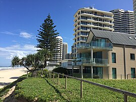
Surfers Paradise is a town and suburb in the City of Gold Coast, Queensland, Australia. In the 2021 census, the suburb of Surfers Paradise had a population of 26,412 people.

<span class="mw-page-title-main">Broadbeach, Queensland</span> Suburb of Gold Coast, Queensland, Australia

Broadbeach is a suburb in the City of Gold Coast, Queensland, Australia. In the 2021 census, Broadbeach had a population of 6,786 people.

<span class="mw-page-title-main">Nerang, Queensland</span> Town in Queensland, Australia

Nerang is a town and suburb in the City of Gold Coast, Queensland, Australia. In the 2021 census, the suburb of Nerang had a population of 17,048 people.

<span class="mw-page-title-main">Southport, Queensland</span> Suburb of Gold Coast, Queensland, Australia

Southport is a coastal town and suburb in the City of Gold Coast in Queensland, Australia. It contains the Gold Coast central business district. In the 2021 census, Southport had a population of 36,786 people.

<span class="mw-page-title-main">Gold Coast Seaway</span>

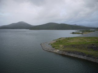
The Gold Coast Seaway or Southport Seaway is the main navigation entrance from the Pacific Ocean into the Gold Coast Broadwater and southern Moreton Bay and is one of Australia's most significant coastal engineering projects. It is located at the northern end of the Southport Spit where the Nerang River enters the Pacific Ocean. The channel was constructed between 1984 and 1986, primarily to facilitate the safe passage of sea-faring vessels. The passage was previously known as the Southport Bar. The mouth of the Nerang River was once located further south in Broadbeach. The main driving force for this movement is the northward drift of sand along the coast.

<span class="mw-page-title-main">Gold Coast Broadwater</span>

The Gold Coast Broadwater, also known as Southport Broadwater, Gold Coast Harbour and The Broadwater, is a large shallow estuary of water located in the Gold Coast district of South East Queensland, Australia. The estuary reaches from the locality of Southport in the south, to the southern section of the UNESCO World Heritage Listed Moreton Bay in the north. Separated via the Seaway from the Coral Sea by a thin strip of land called Stradbroke Island, the original body of water was a lagoon created from water deposited from the Nerang River. Part of the Broadwater is contained within the Moreton Bay Marine Park.

<span class="mw-page-title-main">Southport Spit</span>

The Southport Spit is a spit and neighbourhood within the northern end of Main Beach, City of Gold Coast, Queensland, Australia. It is a permanent sand spit that separates the Southport Broadwater from the Pacific Ocean.

<span class="mw-page-title-main">Carrara, Queensland</span> Suburb of Gold Coast, Queensland, Australia

Carrara is a suburb in the City of Gold Coast, Queensland, Australia. In the 2021 census, Carrara had a population of 13,138 people.

<span class="mw-page-title-main">Ashmore, Queensland</span> Suburb of Gold Coast, Queensland, Australia

Ashmore is a suburb of the City of Gold Coast, Queensland, Australia. In the 2021 census, Ashmore had a population of 12,415 people.

<span class="mw-page-title-main">Bundall, Queensland</span> Suburb of Gold Coast, Queensland, Australia

Bundall is a suburb in the City of Gold Coast, Queensland, Australia. In the 2021 census, Bundall had a population of 4,895 people.

<span class="mw-page-title-main">Molendinar, Queensland</span> Suburb of Gold Coast, Queensland, Australia

Molendinar is a mixed-use suburb in the City of Gold Coast, Queensland, Australia. In the 2021 census, Molendinar had a population of 6,450 people.

Narrow Neck is the name of an isthmus that separates the anabranch of the Nerang River from the Coral Sea in the City of Gold Coast, Queensland, Australia. It is also the boundary between the southern end of the suburb of Main Beach and the northern end of the suburb of Surfers Paradise.

<span class="mw-page-title-main">Ferry Road, Gold Coast</span> Road in Southport, Queensland, Australia

Ferry Road is a road in Southport, on the Gold Coast, Queensland, Australia. Originally a suburban street, it is now part of Southport–Burleigh Road, a state controlled road

<span class="mw-page-title-main">Advancetown, Queensland</span> Suburb of City of Gold Coast, Queensland, Australia

Advancetown is a rural outer locality in the City of Gold Coast, Queensland, Australia. In the 2021 census, Advancetown had a population of 528 people.

<span class="mw-page-title-main">Gilston, Queensland</span> Suburb of City of Gold Coast, Queensland, Australia

Gilston is a rural residential locality in the City of Gold Coast, Queensland, Australia. In the 2021 census, Gilston had a population of 2,669 people.

<span class="mw-page-title-main">Town of Southport</span> Local government area of Queensland, Australia

The Town of Southport was a local government area in South East Queensland, Australia.

Humphreys Boat Shed was a heritage-listed workshop and slipway at Seaworld Drive, Main Beach, Queensland, Australia. It was added to the Queensland Heritage Register on 31 August 2001, but was removed in June 2015 having been destroyed. However the remnants of the boat shed and slipway are listed on the Gold Coast Local Heritage Register. 

<span class="mw-page-title-main">Jubilee Bridge (Southport)</span> Bridge in Gold Coast, Queensland

The Jubilee Bridge (1925–1966) was a bridge across the Nerang River in South East Queensland, Australia. The bridge connected the suburbs of Southport to Main Beach on the Gold Coast, providing the first road connection to Surfers Paradise. It facilitated the development of the Gold Coast beach suburbs and holiday resorts.

<span class="mw-page-title-main">Chevron Island</span> Island in Queensland, Australia

The Chevron Island is an urban island that lies in the Nerang River and is a neighbourhood within the suburb of Surfers Paradise in the City of Gold Coast, Queensland, Australia.

References

  1. 1 2 3 Australian Bureau of Statistics (28 June 2022). "Main Beach (SAL)". 2021 Census QuickStats. Retrieved 28 February 2023. OOjs UI icon edit-ltr-progressive.svg
  2. 1 2 "Main Beach – town in City of Gold Coast (entry 43132)". Queensland Place Names. Queensland Government . Retrieved 20 July 2021.
  3. "Main Beach – suburb in City of Gold Coast (entry 46540)". Queensland Place Names. Queensland Government . Retrieved 20 July 2021.
  4. "Narrow Neck – isthmus in the City of Gold Coast (entry 23901)". Queensland Place Names. Queensland Government . Retrieved 23 December 2021.
  5. "MAIN BEACH ALLOTMENTS". The Queenslander . No. 2947. Queensland, Australia. 24 February 1923. p. 9. Retrieved 23 July 2020 via National Library of Australia.
  6. "Government sale of allotments, Main Beach, Southport" (Cadastral map). Queensland Government. 1923. Archived from the original on 22 July 2020. Retrieved 22 July 2020.
  7. Australian Bureau of Statistics (31 October 2012). "Main Beach (State Suburb)". 2011 Census QuickStats. Retrieved 14 September 2015. OOjs UI icon edit-ltr-progressive.svg
  8. Australian Bureau of Statistics (27 June 2017). "Main Beach (SSC)". 2016 Census QuickStats. Retrieved 20 October 2018. OOjs UI icon edit-ltr-progressive.svg
  9. "Main Beach Pavilion and Southport Surf Lifesaving Club (entry 601265)". Queensland Heritage Register . Queensland Heritage Council. Retrieved 19 June 2013.
  10. Gold Coast Local Heritage Register - A to M, pp. 71-72
  11. "Southport Cable Hut (former) (entry 602611)". Queensland Heritage Register . Queensland Heritage Council. Retrieved 19 June 2013.
  12. Gold Coast Local Heritage Register - N to Z, pp. 121-122
  13. "Humphreys Boat Shed & Slipway (entry 602324)". Queensland Heritage Register . Queensland Heritage Council. Retrieved 19 June 2013.
  14. Gold Coast Local Heritage Register - A to M, pp. 57-58
  15. "Layers: Locality; Schools and school catchments". Queensland Globe. Queensland Government. Archived from the original on 19 December 2017. Retrieved 11 September 2024.
  16. "Marinas - Queensland". Queensland Open Data. Queensland Government. 18 November 2020. Archived from the original on 24 November 2020. Retrieved 24 October 2020.
  17. "Southport Yacht Club". Southport Yacht Club. 11 September 2024. Archived from the original on 6 September 2024. Retrieved 11 September 2024.
  18. 1 2 3 "Recreational Boating Facilities Queensland". Queensland Open Data. Queensland Government. 12 November 2020. Archived from the original on 22 November 2020. Retrieved 22 November 2020.
  19. 1 2 3 4 5 6 7 8 9 10 11 12 13 14 15 16 "Land for public recreation - Queensland". Queensland Open Data. Queensland Government. 20 November 2020. Archived from the original on 22 November 2020. Retrieved 22 November 2020.
  20. "Landmark Areas - Queensland". Queensland Open Data. Queensland Government. 18 November 2020. Archived from the original on 21 November 2020. Retrieved 21 October 2020.
  21. "Main Beach". Gold Coast City Council . 13 October 2021. Archived from the original on 13 March 2024. Retrieved 11 September 2024.

Sources