Maudsland, Queensland

Last updated

Map all coordinates using: OpenStreetMap  
Download coordinates as: KML
Maudsland
Queensland
Park along Tuxedo Junction Drive, Maudsland, Queensland.jpg
Park along Tuxedo Junction Drive, 2016
Australia Queensland location map.svg
Red pog.svg
Maudsland
Coordinates 27°56′27″S153°16′51″E / 27.9408°S 153.2808°E / -27.9408; 153.2808 (Maudsland (centre of locality)) Coordinates: 27°56′27″S153°16′51″E / 27.9408°S 153.2808°E / -27.9408; 153.2808 (Maudsland (centre of locality))
Population5,568 (2016 census) [1]
 • Density384.0/km2 (995/sq mi)
Postcode(s) 4210
Area14.5 km2 (5.6 sq mi)
Time zone AEST (UTC+10:00)
Location
LGA(s) City of Gold Coast
State electorate(s) Theodore
Federal division(s) Wright
Suburbs around Maudsland:
Upper Coomera Oxenford Oxenford
Guanaba Maudsland Pacific Pines
Mount Nathan Mount Nathan Nerang

Maudsland is a rural-residential locality in the north of the City of Gold Coast, Queensland, Australia. [2] In the 2016 census, Maudsland had a population of 5,568 people. [1]

Contents

Maudsland features acreage properties, a number of housing estates including acreage and neighbourhood ones. The suburb's postcode is 4210.

Geography

Maudsland is bounded by the Coomera River in the north and west, the Pacific Motorway, Universal Street, Hervey Street, Binstead Way, Kopps Road, Saltwater Creek, Greenway Boulevard, Roberts Drive and the locality of Pacific Pines in the east, and the locality of Nerang, Beaudesert-Nerang Road and Maudsland Road in the south.[ citation needed ]

In June 2008 a police tactical operation occurred on Gellert Close in the suburb due to a Vietnam veteran experiencing a PTSD (Post Traumatic Stress Disorder) flashback episode. The episode was triggered by the neighbourhood children playing in the street. After 12 hours of police negotiations, the siege ended without any major fatalities . The 43 year old perpetrator was later charged with the offence. https://www.abc.net.au/news/2008-07-31/43yo-man-charged-over-gc-siege/459692

The northern and north-east parts of the locality are suburban housing estates with the remainder of the locality has lower-density rural residential housing. There is a large undeveloped area in the more mountainous centre of the locality where unnamed peaks rise to 170 metres (560 ft). [3]

History

Maudsland Provisional School opened on 13 October 1879 under head teacher John William Scott and became a state school on 1 January 1909. It closed on 15 April 1963 and its remaining students and its buildings were transferred to Coomera State School. The school was at 542 Maudsland Road ( 27°56′44″S153°16′12″E / 27.9456°S 153.2701°E / -27.9456; 153.2701 (Maudsland State School (former)) ). [4] The school grounds were converted to Cliff Bird Park by the Albert Shire Council. [5] [6] [7] [8] [9]

Maudsland was connected to the telephone network in 1924. [10]

The Maudsland Village Shopping Centre and an adjacent childcare centre were severely damaged by fire in August 2012. [11] [12] Neighbouring businesses including a liquor store and tavern were undamaged. The shopping centre reopened in 2013.

In the 2016 census, Maudsland had a population of 5,568 people. [1]

Estates

Acreage estates include Huntington Downs and Tuxedo Junction, both off Maudsland Road, one of the busier and important roads in the suburb. There are also non-acreage neighbourhood estates such as Parklake and Riverstone Crossing, and Huntington Rise is being constructed.[ citation needed ]

Education

There are no schools in Maudsland. The nearest government primary schools are Park Lake State School in neighbouring Pacific Pines to the east and Gaven State School in neighbouring Oxenford to the north-east. The nearest government secondary schools are Pacific Pines State High School in neighbouring Pacific Pines to the east and Nerang State High School in neighbouring Nerang to the south-east. [3]

Facilities

Maudsland Waste and Recycling Centre is at 7 Holyrood Street ( 27°56′00″S153°16′38″E / 27.9334°S 153.2772°E / -27.9334; 153.2772 (Maudsland Waste and Recycling Centre) ). [13]

Amenities

Facilities in Maudsland include a large park and playground in the estate of Parklake, with a field, barbecue and picnic facilities, and play areas.[ citation needed ]

Related Research Articles

Nerang, Queensland Suburb of Gold Coast, Queensland, Australia

Nerang is a town and suburb in the City of Gold Coast, Queensland, Australia. In the 2016 census, Nerang had a population of 16,864 people.

Pacific Motorway (Brisbane–Brunswick Heads)

The Pacific Motorway is a motorway in Australia between Brisbane, Queensland, and Brunswick Heads, New South Wales, through the New South Wales–Queensland border at Tweed Heads.

Helensvale railway station

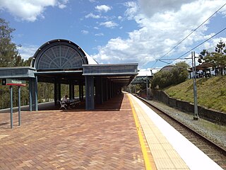
Helensvale railway station is a major public transport interchange in the Gold Coast suburb of Helensvale. Helensvale railway station is served by the Queensland Rail Citytrain network Gold Coast line, G:link light rail and Surfside Buslines bus services.

Helensvale, Queensland Suburb of Gold Coast, Queensland, Australia

Helensvale is a suburb of the City of Gold Coast in Queensland, Australia. In the 2016 census, Helensvale had a population of 16,862 people.

Ashmore is an inner city suburb in the City of Gold Coast, Queensland, Australia. In the 2016 census, Ashmore had a population of 11,910 people.

Oxenford, Queensland Suburb of Gold Coast, Queensland, Australia

Oxenford is a suburb in the City of Gold Coast, Queensland, Australia. In the 2016 census, Oxenford had a population of 11,842 people.

Upper Coomera, Queensland Suburb of City of Gold Coast, Queensland, Australia

Upper Coomera is a suburb in the City of Gold Coast, Queensland, Australia. In the 2016 census, Upper Coomera had a population of 25,276 people.

Clagiraba, Queensland Suburb of Gold Coast, Queensland, Australia

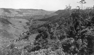
Clagiraba is a rural locality in the City of Gold Coast, Queensland, Australia. In the 2016 census, Clagiraba had a population of 601 people.

Coomera, Queensland Town in Queensland, Australia

Coomera is a town and suburb in the City of Gold Coast, Queensland, Australia. In the 2016 census, Coomera had a population of 13,305 people.

Pacific Pines, Queensland Suburb of Gold Coast, Queensland, Australia

Pacific Pines is a northern suburb in the City of Gold Coast, Queensland, Australia. In the 2016 census, Pacific Pines had a population of 16,757 people.

Advancetown, Queensland Suburb of Gold Coast, Queensland, Australia

Advancetown is a rural outer locality in the City of Gold Coast, Queensland, Australia. In the 2016 census, Advancetown had a population of 482 people.

Gaven is a rural residential locality in the City of Gold Coast, Queensland, Australia. In the 2016 census, Gaven had a population of 1,558 people.

Guanaba is a semi-rural locality in the City of Gold Coast, Queensland, Australia. In the 2016 census, Guanaba had a population of 793 people.

Shire of Coomera

The Shire of Coomera was a local government area in South East Queensland, Australia. The shire, administered from Coomera, existed as a local government entity from 1879 until 1949.

The Town of South Coast was a local government area in South East Queensland, Australia.

Witheren is a rural locality in the Scenic Rim Region, Queensland, Australia. In the 2016 census Witheren had a population of 496 people.

Willow Vale, Queensland Suburb of Gold Coast City, Queensland, Australia

Willow Vale is a rural locality in the City of Gold Coast, Queensland, Australia. In the 2016 census, Willow Vale had a population of 2,096 people.

Wongawallan, Queensland Suburb of City of Gold Coast, Queensland, Australia

Wongawallan is a rural locality in the City of Gold Coast, Queensland, Australia. In the 2016 census Wongawallan had a population of 1,273 people.

Electoral district of Theodore State electoral district of Queensland, Australia

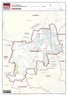
Theodore is an electoral district of the Legislative Assembly in the Australian state of Queensland. It was created in the 2017 redistribution, and was won at the 2017 election by Mark Boothman. It is named after former Queensland Premier, Ted Theodore. From results of the most recent election, Theodore is a marginal seat for the Liberal National Party with a margin of 3.7%.

Flying Fox, Queensland Suburb of Scenic Rim Region, Queensland, Australia

Flying Fox is a rural locality in the Scenic Rim Region, Queensland, Australia. In the 2016 census, Flying Fox had a population of 65 people.

References

  1. 1 2 3 Australian Bureau of Statistics (27 June 2017). "Maudsland (SSC)". 2016 Census QuickStats. Retrieved 20 October 2018. OOjs UI icon edit-ltr-progressive.svg
  2. "Maudsland – locality in City of Gold Coast (entry 49319)". Queensland Place Names. Queensland Government . Retrieved 20 July 2021.
  3. 1 2 "Queensland Globe". State of Queensland . Retrieved 29 December 2021.
  4. "Queensland Two Mile series sheet 2m37" (Map). Queensland Government. 1953. Archived from the original on 29 December 2021. Retrieved 30 December 2021.
  5. "Opening and closing dates of Queensland Schools". Queensland Government . Retrieved 11 June 2014.
  6. Queensland Family History Society (2010), Queensland schools past and present (Version 1.01 ed.), Queensland Family History Society, ISBN   978-1-921171-26-0
  7. "Agency ID 6193, Maudsland State School". Queensland State Archives . Retrieved 12 June 2014.
  8. "History". Coomera State School. Coomera State School. Archived from the original on 14 July 2014. Retrieved 12 June 2014.
  9. "Gold Coast Inner Hinterland". Queensland Places. Centre for the Government of Queensland, University of Queensland. Archived from the original on 14 July 2014. Retrieved 30 December 2021.
  10. "Telephone for Maudsland". The Brisbane Courier . National Library of Australia. 24 January 1924. p. 5. Archived from the original on 29 December 2021. Retrieved 12 June 2014.
  11. "Shopping complex destroyed by fire on Maudsland Rd and Killarney Ct at Oxenford on the Gold Coast". The Courier Mail. 20 August 2012. Archived from the original on 28 August 2017. Retrieved 28 August 2017.
  12. "Maudsland Shopping Village Case Study" (PDF). Bay Building Group. Archived (PDF) from the original on 23 February 2017. Retrieved 28 August 2017.
  13. "Building points - Queensland". Queensland Open Data. Queensland Government. 17 November 2020. Archived from the original on 25 November 2020. Retrieved 25 November 2020.

Further reading