Currumbin Valley, Queensland

Last updated

Currumbin Valley
Gold Coast City,  Queensland
Currumbin Creek at Robert Neumann Park in Currumbin Valley, Queensland.jpg
Currumbin Creek at Robert Neumann Park, 2015
Australia Queensland location map.svg
Red pog.svg
Currumbin Valley
Coordinates 28°12′06″S153°24′00″E / 28.2016°S 153.4°E / -28.2016; 153.4 (Currumbin Valley (centre of locality))
Population2,084 (SAL 2021) [1]
Postcode(s) 4223
Area35.0 km2 (13.5 sq mi)
Time zone AEST (UTC+10:00)
Location
LGA(s) City of Gold Coast
State electorate(s) Currumbin
Federal division(s) McPherson
Suburbs around Currumbin Valley:
Tallebudgera Elanora Currumbin Waters
Tallebudgera Valley Currumbin Valley Piggabeen (NSW)
Dungay (NSW) Tomewin (NSW) Glengarrie (NSW)

Currumbin Valley is a rural locality in the City of Gold Coast, Queensland, Australia. [2] It borders New South Wales. [3] In the 2021 census, Currumbin Valley had a population of 2,084 people. [4]

Contents

Geography

Currumbin Ecovillage, 2015 Roadside at the Currumbin Ecovillage at Currumbin Waters, Queensland.jpg
Currumbin Ecovillage, 2015

Currumbin Valley is in the Gold Coast hinterland of South East Queensland bounded to the south by the Queensland border with New South Wales. [5]

The valley is relatively small in size being approximately twenty-four kilometers long and around four kilometers wide. [6] Furthermore, Currumbin Valley provides both rural and residential land but is predominantly rural. [7] Currumbin Valley is a unique part of Australia’s Green Cauldron, being the first valley to the north of the escarpment of the cauldron (the temple of which is Mount Warning) in the Murwillumbah region, to the south. [8]

The main road through Currumbin Valley – Currumbin Creek Road extends 20 kilometres west to the Mt Cougal Section of the Springbrook National Park, where it terminates, with a World-Heritage-Listed rainforest walk, the Cougal Cascades (waterfalls) and abundant, native flora and fauna. [9] This pristine rainforest is part of the eastern section of the Gondwana Rainforests of Australia. [9]

History

The Currumbin Valley was predominantly used for timber getting and grazing – the settlement date of this area dates from the 1840s. [10]

In the 1870s and 1880s many banana plantations, sugar crops and dairy farms were established. [10] This therefore enabled the minimal population to grow. [10]

Again some growth took place during the early 1900s, following the construction of the railway line. [10] [ when? ]

Currumbin Upper Provisional School opened on 21 September 1908. On 1 January 1909, it became Currumbin State School. Between 1922 and 1923, the school closed due to low student numbers. On 16 June 1966, the school was renamed Currumbin Valley State School. [11]

In December 1926, it was decided to build a Presbyterian church. John Boyd donated the land and Alexander Mayes, a retired builder, drew up the plans and supervised the work. [12] The Upper Currumbin Presbyterian Church was officially opened on Saturday 23 April 1927 by Reverend William Herman Waters, Moderator of the Presbyterian Church in Queensland. [13] When the Presbyterian Church amalgamated into the Uniting Church in Australia in 1977, it became Currumbin Valley Uniting Church, later Currumbin Valley Community Church. [14]

Significant development occurred from the 1970s. [10]

However, significant growth took place during the 1990s, a result of new dwellings being added to the area. [10]

Growth slowed between 2001 and 2011 as fewer new dwellings were added. [10]

Demographics

In the 2016 census, Currumbin Valley had a population of 1,849 people. [15]

In the 2021 census, Currumbin Valley had a population of 2,084 people. [4]

Education

Currumbin Valley State School is a government primary (Preparatory to Year 6) school for boys and girls at 1223 Currumbin Creek Road ( 28°12′23″S153°23′39″E / 28.2064°S 153.3943°E / -28.2064; 153.3943 (Currumbin Valley State School) ). [16] [17] In 2018, the school had an enrolment of 171 students with 17 teachers (10 full-time equivalent) and 8 non-teaching staff (5 full-time equivalent). [18]

There are no secondary schools in Currumbin Valley. The nearest government secondary school is Elanora State High School in neighbouring Elanora to the north. [3]

Amenities

The Gold Coast City Council operates a fortnightly mobile library service which visits Currumbin Valley State School on Currumbin Creek Road. [19]

Currumbin Valley Uniting Church is at 1326 Currumbin Creek Road ( 28°12′44″S153°23′17″E / 28.2121°S 153.3881°E / -28.2121; 153.3881 (Currumbin Valley Uniting Church) ). [20] [21] [22]

Attractions

Currumbin Rock Pools, 2022 Cooling Down. Currumbin Rock Pools, 2022.jpg
Currumbin Rock Pools, 2022

The Currumbin Valley Rock Pool is located 12 km inland from Currumbin beach, and is a popular attraction for locals. [23] [24] Springbrook also offers a number of walking trails around the rainforest. Information about the walking trails around the Springbrook National Park can be found at the Rangers offices in Natural Bridge or Springbrook. [25] Nicoll Scrub National Park is a protected area in Queensland, 88 km southeast of Brisbane. It adjoins the Currumbin Valley Reserve and protects remnant rainforest vegetation. [26]

Related Research Articles

<span class="mw-page-title-main">Springbrook National Park</span> Protected area in Queensland, Australia

The Springbrook National Park is a protected national park that is located in the Gold Coast hinterland of Queensland, Australia. The 6,197-hectare (15,310-acre) park is situated on the McPherson Range, near Springbrook, approximately 100 kilometres (62 mi) south of Brisbane. The park is part of the Shield Volcano Group of the UNESCO World Heritage–listed Gondwana Rainforests of Australia.

<span class="mw-page-title-main">Coolangatta</span> Suburb of Gold Coast, Queensland, Australia

Coolangatta is a coastal suburb in the City of Gold Coast, Queensland, Australia. It is the Gold Coast's southernmost suburb and it borders New South Wales. In the 2016 census, Coolangatta had a population of 5,948 people.

<span class="mw-page-title-main">Burleigh Heads, Queensland</span> Suburb of Gold Coast, Queensland, Australia

Burleigh Heads is a suburb in the City of Gold Coast, Queensland, Australia. In the 2016 census, Burleigh Heads had a population of 10,077 people.

<span class="mw-page-title-main">Currumbin, Queensland</span> Suburb of Gold Coast, Queensland, Australia

Currumbin is a coastal suburb in the City of Gold Coast, Queensland, Australia. In the 2016 census, Currumbin had a population of 2,920 people.

<span class="mw-page-title-main">Mudgeeraba, Queensland</span> Suburb of City of Gold Coast, Queensland, Australia

Mudgeeraba is a town and suburb in the City of Gold Coast, Queensland, Australia. In the 2016 census, the suburb of Mudgeeraba had a population of 13,624 people.

<span class="mw-page-title-main">Palm Beach, Queensland</span> Suburb of Gold Coast, Queensland, Australia

Palm Beach is a coastal suburb in the City of Gold Coast, Queensland, Australia. In the 2016 census, Palm Beach had a population of 14,654 people.

<span class="mw-page-title-main">City of Gold Coast</span> Local government area in Queensland, Australia

The City of Gold Coast is the local government area spanning the Gold Coast, Queensland, Australia and surrounding areas. With a population of 606,774 it is the second most populous local government area in the State of Queensland. Its council maintains a staff of over 2,500. It was established in 1948, but has existed in its present form since 2008. It is on the border with New South Wales with the Tweed Shire to the south in New South Wales.

<span class="mw-page-title-main">Ashmore, Queensland</span> Suburb of Gold Coast, Queensland, Australia

Ashmore is a suburb of the City of Gold Coast, Queensland, Australia. In the 2016 census, Ashmore had a population of 11,910 people.

<span class="mw-page-title-main">Canungra, Queensland</span> Town in Queensland, Australia

Canungra is a rural town and locality in the Scenic Rim Region, Queensland, Australia. In the 2016 census, the locality of Canungra had a population of 1,229 people.

<span class="mw-page-title-main">Bokarina, Queensland</span> Suburb of Sunshine Coast, Queensland, Australia

Bokarina is a coastal suburb in the Sunshine Coast Region, Queensland, Australia, located within the Kawana Waters urban centre. In the 2016 census, Bokarina had a population of 1,351 people.

<span class="mw-page-title-main">Elanora, Queensland</span> Suburb of Gold Coast, Queensland, Australia

Elanora is a suburb of the City of Gold Coast in Queensland, Australia. In the 2016 census, Elanora had a population of 12,145 people.

<span class="mw-page-title-main">Numinbah Valley</span> Town in Queensland, Australia

Numinbah Valley is a rural locality in the City of Gold Coast, Queensland, Australia. In the 2016 census, Numinbah Valley had a population of 218 people.

<span class="mw-page-title-main">Beechmont, Queensland</span> Suburb of Scenic Rim Region, Queensland, Australia

Beechmont is a rural town and locality in the Scenic Rim Region, Queensland, Australia. In the 2016 census, the locality of Beechmont had a population of 842 people.

<span class="mw-page-title-main">Electoral district of Currumbin</span> State electoral district of Queensland, Australia

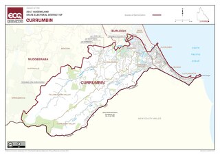
Currumbin is an electoral district of the Legislative Assembly in the Australian state of Queensland.

<span class="mw-page-title-main">Gold Coast hinterland</span> Scenic area and region of South East Queensland, Australia

The Gold Coast hinterland is an area of South East Queensland, Australia that comprises the Tweed Range, Nimmel Range, Tamborine Mountain, Numinbah Valley, eastern parts of the McPherson Range and western parts of suburban Gold Coast, such as Mudgeeraba. This undefined unit of area is known for its tourist attractions including resorts, rainforest, lookouts, national parks, its diversity of fauna and flora and as a green backdrop to the coastal strip. It overlaps part of the Scenic Rim and is part of both the City of Gold Coast and Scenic Rim Region and includes Springbrook, Binna Burra and O'Reilly.

<span class="mw-page-title-main">Tallebudgera, Queensland</span> Suburb of Gold Coast, Queensland, Australia

Tallebudgera is a suburb in the City of Gold Coast, Queensland, Australia. In the 2021 census, Tallebudgera had a population of 3,826 people.

<span class="mw-page-title-main">Currumbin Creek</span> River in Queensland, Australia

The Currumbin Creek is a creek in South East Queensland, Australia. Its catchment lies within the Gold Coast local government area and covers an area of 489 square kilometres (189 sq mi). The river is approximately 24 kilometres (15 mi) in length and provides a popular and tranquil setting for many rowing clubs, kayakers, jet skiers, boat-goers and fishermen.

<span class="mw-page-title-main">Springbrook, Queensland</span> Town in Queensland, Australia

Springbrook is a rural town and locality in the City of Gold Coast, Queensland, Australia. In the 2016 census, the locality of Springbrook had a population of 659 people.

<span class="mw-page-title-main">Currumbin Waters, Queensland</span> Suburb of Gold Coast City, Queensland, Australia

Currumbin Waters is a suburb in the City of Gold Coast, Queensland, Australia. It borders New South Wales. In the 2021 census, Currumbin Waters had a population of 9,797 people.

References

  1. Australian Bureau of Statistics (28 June 2022). "Currumbin Valley (Suburb and Locality)". Australian Census 2021 QuickStats. Retrieved 28 June 2022.  OOjs UI icon edit-ltr-progressive.svg
  2. "Currumbin Valley – locality in City of Gold Coast (entry 46044)". Queensland Place Names. Queensland Government . Retrieved 4 November 2019.
  3. 1 2 "Queensland Globe". State of Queensland . Retrieved 8 August 2023.
  4. 1 2 Australian Bureau of Statistics (28 June 2022). "Currumbin Valley (SAL)". 2021 Census QuickStats. Retrieved 28 February 2023. OOjs UI icon edit-ltr-progressive.svg
  5. Big Volcano. "Northern Rivers, Gold Coast Hinterland and Scenic Rim". Volcano Villages. Tourism Marketing & Media. Archived from the original on 3 June 2014. Retrieved 10 June 2014.
  6. Whereis. "Map of Currumbin Valley, QLD 4223". Sensis Pty Ltd. White Pages. Archived from the original on 28 June 2013. Retrieved 11 June 2014.
  7. Tallebudgera and Currumbin Valleys. "Currumbin Valley" (PDF). Gold Coast City Council. Archived (PDF) from the original on 11 February 2014. Retrieved 11 June 2014.
  8. New South Wales Government. "Wollumbin National Park". Office of Environment and Heritage. New South Wales National Parks and Wildlife service. Archived from the original on 2 May 2014. Retrieved 12 June 2014.
  9. 1 2 Southern Gold Coast. "Discover Currumbin Valley". Gold Coast City Council. Archived from the original on 20 September 2014. Retrieved 15 June 2014.
  10. 1 2 3 4 5 6 7 The City of Gold Coast. "Profile Areas: Currumbin Valley - Tallebudgera". Community Profiles. Archived from the original on 16 May 2014. Retrieved 14 June 2014.
  11. Queensland Family History Society (2010), Queensland schools past and present (Version 1.01 ed.), Queensland Family History Society, ISBN   978-1-921171-26-0
  12. "TWEED HEADS". The Northern Star . Vol. 51. New South Wales, Australia. 24 December 1926. p. 7. Archived from the original on 8 August 2023. Retrieved 13 September 2021 via National Library of Australia.
  13. "CHURCH NEWS". The Brisbane Courier . No. 21, 609. Queensland, Australia. 30 April 1927. p. 7. Archived from the original on 8 August 2023. Retrieved 13 September 2021 via National Library of Australia.
  14. "Currumbin Valley Community Church". Churches Australia. Archived from the original on 14 September 2021. Retrieved 14 September 2021.
  15. Australian Bureau of Statistics (27 June 2017). "Currumbin Valley (SSC)". 2016 Census QuickStats. Retrieved 20 October 2018. OOjs UI icon edit-ltr-progressive.svg
  16. "State and non-state school details". Queensland Government. 9 July 2018. Archived from the original on 21 November 2018. Retrieved 21 November 2018.
  17. "Currumbin Valley State School". Currumbin Valley State School. 5 September 2022. Archived from the original on 14 May 2023. Retrieved 8 August 2023.
  18. "ACARA School Profile 2018". Australian Curriculum, Assessment and Reporting Authority. Archived from the original on 27 August 2020. Retrieved 28 January 2020.
  19. "Mobile Library 2018 timetable" (PDF). Gold Coast City Council . Archived from the original (PDF) on 30 January 2018. Retrieved 30 January 2018.
  20. "Find a Church". Uniting Church in Australia, Queensland Synod. Archived from the original on 24 October 2020. Retrieved 22 November 2020.
  21. "Currumbin Valley Church". Elanora Uniting Church. Archived from the original on 12 September 2021. Retrieved 12 September 2021.
  22. Blake, Thom. "Currumbin Valley Presbyterian Church". Queensland religious places database. Archived from the original on 12 September 2021. Retrieved 12 September 2021.
  23. McMahon, Alle. "Currumbin Valley Rock Pools". Weekend notes. On Topic Media PTY LTD. Archived from the original on 21 June 2014. Retrieved 15 June 2014.
  24. Lidster, Deb. "currumbin rock pools currumbin valley". Must do in Brisbane.com. Archived from the original on 19 July 2014. Retrieved 15 June 2014.
  25. Australian Explorer Pty Ltd. "Springbrook National Park". Australian Explorer Pty Ltd Since. Archived from the original on 2 July 2014. Retrieved 15 June 2014.
  26. TouristLink.com. "Nicoll Scrub National Park". Archived from the original on 20 August 2018. Retrieved 15 June 2014.