Runaway Bay, Queensland

Last updated

Map all coordinates using: OpenStreetMap
Runaway Bay
Gold Coast,  Queensland
Bayview Harbour, Runaway Bay, Gold Coast, February 1989.jpg
Bayview Harbour, 1989
Gold Coast locator map.svg
Red pog.svg
Runaway Bay
Coordinates 27°54′51″S153°24′02″E / 27.9141°S 153.4005°E / -27.9141; 153.4005 (Runaway Bay (centre of suburb))
Population9,068 (2016 census) [1]
 • Density1,225/km2 (3,174/sq mi)
Postcode(s) 4216
Elevation5 m (16 ft)
Area7.4 km2 (2.9 sq mi)
Time zone AEST (UTC+10:00)
Location
LGA(s) City of Gold Coast
State electorate(s) Broadwater
Federal division(s) Fadden
Suburbs around Runaway Bay:
Coombabah Hollywell South Stradbroke
Coombabah Runaway Bay South Stradbroke
Coombabah Biggera Waters South Stradbroke

Runaway Bay is a coastal suburb in the City of Gold Coast, Queensland, Australia. [2] In the 2016 census, Runaway Bay had a population of 9,068 people. [1]

Contents

The neighbourhood of Anglers Paradise ( 27°55′24″S153°23′56″E / 27.9233°S 153.3989°E / -27.9233; 153.3989 (Anglers Paradise) ) is situated within Runaway Bay. [3] It is the southern area of Runaway Bay developed before 1967.

Geography

The suburb is bounded by Poinsettia Avenue in the north, by Oxley Drive and Pine Ridge Road to the west, by Coombabah Road and Biggera Creek ( 27°55′30″S153°24′22″E / 27.9249°S 153.4060°E / -27.9249; 153.4060 (Biggera Creek) ) to the south. In the east, the suburb's boundaries extend into the Gold Coast Broadwater. [4] [5]

Of the actual land surface, the land use is residential with the exception of the north-western corner of the suburb which is part of the Pine Ridge Conservation Park ( 27°54′00″S153°23′34″E / 27.9000°S 153.3928°E / -27.9000; 153.3928 (Pine Ridge Conservation Park) ) which extends north into Hollywell. [5]

Within its sea area, there is:

There is a bridge in the south-east of the locality across the mouth of Biggera Creek to the Lands End headland in Biggera Waters to the south. [5]

History

In 1939, Robert George Oates (as the Anglers Paradise Development Company) bought 350 acres (140 ha) of land along Biggera Creek (around Ocean Street) and the Broadwater (around Bayview Street). By mid 1950s, there was a town water supply and about 50 homes, both permanent residences and holiday homes. [8] In 1960 the construction of the bridge across the mouth of Biggera Creek to Lands End (then in Labrador) encouraged further development in the area. [9]

In 1967, the Lae Enterprises company bought 182 hectares (450 acres) of land north of Anglers Paradise along the western shore of the Broadwater. Development started in 1972 to transform the subdivision into a residential and boating area. The name "Runaway Bay" was coined to promote the area as a tranquil retreat. [10] Initially the name was rejected as an official suburb name, but it was used for the local post office, which led to it becoming the official suburb name. [2]

St Francis Xavier's Catholic School opened on 28 January 1975. [11] From that time until 1980, Catholic church services were held at the school by priests from the Southport parish. On 5 October 1980 a separate parish was formed with Father Basil Nolan as the first priest. The Holy Family Catholic Church opened in 1983. [12]

The Runaway Bay Library opened in 1992 with a major refurbishment in 2011. [13]

The Sports Super Centre was established in 2000 by runner Ron Clarke. In 2010 it was expanded to include an education program for schools. In 2011 it was sold to the Queensland Government. [14] [15]

In the 2016 census, Runaway Bay had a population of 9,068 people. [1]

Education

St Francis Xavier School is a Catholic primary (Prep-6) school for boys and girls at 160 Bayview Street ( 27°54′35″S153°24′07″E / 27.9096°S 153.4020°E / -27.9096; 153.4020 (St Francis Xavier School) ). [16] [17] In 2018, the school had an enrolment of 627 students with 36 teachers (31 full-time equivalent) and 34 non-teaching staff (24 full-time equivalent). [18]

Runaway Bay Sport and Leadership Excellence Centre is a government sports education centre on the corner of Sports Drive and Morala Ave ( 27°54′38″S153°23′51″E / 27.9105°S 153.3975°E / -27.9105; 153.3975 (Runaway Bay Sport and Leadership Excellence Centre) ). [16] [19]

There are no regular government schools in Runaway Bay. The nearest government primary schools are Biggera Waters State School in neighbouring Biggera Waters to the south and Coombabah State School in neighbouring Coombabah to the north-west. The nearest government secondary school is Coombabah State High School in neighbouring Coombabah to the south-west. [5]

Facilities

Runaway Bay Police Station is at 190 Morala Avenue ( 27°54′43″S153°23′52″E / 27.9120°S 153.3977°E / -27.9120; 153.3977 (Runaway Bay Police Station) ). [20]

Runaway Bay Ambulance Station is at 2 Sports Drive ( 27°54′40″S153°23′52″E / 27.9112°S 153.3977°E / -27.9112; 153.3977 (Runaway Bay Ambulance Station) ). [20]

Runaway Bay has its State Emergency Service facility off Sports Drive ( 27°54′41″S153°23′45″E / 27.9113°S 153.3958°E / -27.9113; 153.3958 (Runaway Bay SES Facility) ). [20]

Amenities

Runaway Bay Shopping Centre is in Lae Drive ( 27°54′46″S153°23′59″E / 27.9129°S 153.3996°E / -27.9129; 153.3996 (Runaway Bay shopping centre) ). [21] Runaway Bay Post office is within the centre. [22]

There is a cluster of fast food restaurants on the corner of Lae Drive and Oxley Drive ( 27°54′45″S153°23′20″E / 27.9126°S 153.3889°E / -27.9126; 153.3889 (fast food precinct) ). [23]

The Gold Coast City Council operates a public library in Lae Drive ( 27°54′41″S153°23′57″E / 27.9113°S 153.3991°E / -27.9113; 153.3991 (Runaway Bay Library) ) next to the community centre. [24]

Holy Family Catholic Church is in Simbai Street ( 27°54′32″S153°24′04″E / 27.9090°S 153.4010°E / -27.9090; 153.4010 (Holy Family Catholic Church) ) adjacent to the Catholic school. [21]

Natural amenities include Pine Ridge Conservation Park and numerous other parks:

There are two boat ramps in Runaway Bay, both managed by the Gold Coast City Council: [31]

Sport and recreation

The Sports Super Centre is a premier sports training and events facility in the Gold Coast. Facilities accommodate athletics, cricket, AFL, netball, soccer and indoor sports. The sports centre in Lae Drive ( 27°54′33″S153°23′50″E / 27.9093°S 153.3973°E / -27.9093; 153.3973 (Sports Super Centre) ) includes a stadium, sports medicine facility, gymnasium and Olympic aquatic centre. [32]

The suburb is also home to the Runaway Bay Junior Rugby League club, which was formed in 1974 after local residents met at the old Runaway Bay shopping centre with the intention of forming a club for kids to play sport. [33]

Bayview Harbour Yacht Squadron has a 2.2-hectare (5.4-acre) marina on Oatland Esplanade ( 27°55′25″S153°24′23″E / 27.9237°S 153.4065°E / -27.9237; 153.4065 (Bayview Harbour Yacht Squadron) ) with access to the Gold Coast Broadwater. [34] [35]

A number of well-known sporting teams represent the local area, including the rugby league team, the Runaway Bay Seagulls.

See also

Related Research Articles

<span class="mw-page-title-main">Main Beach, Queensland</span> Suburb of Gold Coast, Queensland, Australia

Main Beach is a coastal town and suburb in the City of Gold Coast, Queensland, Australia. In the 2016 census, the suburb of Main Beach had a population of 3,883 people.

<span class="mw-page-title-main">Southport, Queensland</span> Suburb of Gold Coast, Queensland, Australia

Southport is a coastal town and suburb in the City of Gold Coast in Queensland, Australia. It contains the Gold Coast central business district. In the 2021 census, Southport had a population of 36,786 people.

Harbour Town is a shopping centre concept in Australia that incorporates multiple factory outlets in one centre. As of February 2021, there are two locations owned and operated under the Harbour Town brand: Biggera Waters, on Queensland's Gold Coast, and at Adelaide Airport, in South Australia. Harbour Town centres also operated in Perth, Western Australia and Docklands, Victoria before being sold off and rebranded.

<span class="mw-page-title-main">Gold Coast Broadwater</span>

The Gold Coast Broadwater, also known as Southport Broadwater, Gold Coast Harbour and The Broadwater, is a large shallow estuary of water located in the Gold Coast district of South East Queensland, Australia. The estuary reaches from the locality of Southport in the south, to the southern section of the UNESCO World Heritage Listed Moreton Bay in the north. Separated via the Seaway from the Coral Sea by a thin strip of land called Stradbroke Island, the original body of water was a lagoon created from water deposited from the Nerang River. Part of the Broadwater is contained within the Moreton Bay Marine Park.

<span class="mw-page-title-main">Electoral district of Broadwater</span> State electoral district of Queensland, Australia

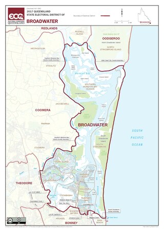
Broadwater is an electoral district of the Legislative Assembly in the Australian state of Queensland. It was created at the 1991 redistribution.

<span class="mw-page-title-main">Broadbeach Waters, Queensland</span> Suburb of Gold Coast, Queensland, Australia

Broadbeach Waters is a suburb in the City of Gold Coast, Queensland, Australia. In the 2021 census, Broadbeach Waters had a population of 8,164 people.

<span class="mw-page-title-main">Helensvale, Queensland</span> Suburb of Gold Coast, Queensland, Australia

Helensvale is a suburb of the City of Gold Coast in Queensland, Australia. In the 2016 census, Helensvale had a population of 16,862 people.

<span class="mw-page-title-main">Southport Spit</span>

The Southport Spit is a spit and neighbourhood within the northern end of Main Beach, City of Gold Coast, Queensland, Australia. It is a permanent sand spit that separates the Southport Broadwater from the Pacific Ocean.

<span class="mw-page-title-main">Biggera Waters, Queensland</span> Suburb of Gold Coast, Queensland, Australia

Biggera Waters is a coastal suburb in the City of Gold Coast, Queensland, Australia. In the 2016 census, Biggera Waters had a population of 8,534 people.

<span class="mw-page-title-main">Coombabah</span> Suburb of Gold Coast, Queensland, Australia

Coombabah is a suburb in the City of Gold Coast, Queensland, Australia. In the 2016 census, Coombabah had a population of 10,388 people.

<span class="mw-page-title-main">Hope Island, Queensland</span> Suburb of Gold Coast, Queensland, Australia

Hope Island is a suburb in the City of Gold Coast, Queensland, Australia. In the 2016 census, Hope Island had a population of 11,186 people.

<span class="mw-page-title-main">Labrador, Queensland</span> Suburb of Gold Coast, Queensland, Australia

Labrador is a coastal suburb in the City of Gold Coast, Queensland, Australia. In the 2016 census, Labrador had a population of 18,261 people.

<span class="mw-page-title-main">Banksia Beach, Queensland</span> Suburb of Bribie Island, Queensland, Australia

Banksia Beach is a town and suburb on Bribie Island in the City of Moreton Bay, Queensland, Australia. In the 2016 census the suburb of Banksia Beach had a population of 5,995 people.

<span class="mw-page-title-main">Mermaid Waters, Queensland</span> Suburb of Gold Coast, Queensland, Australia

Mermaid Waters is a suburb in the City of Gold Coast, Queensland, Australia. In the 2016 census, Mermaid Waters had a population of 12,045 people.

<span class="mw-page-title-main">Arundel, Queensland</span> Suburb of Gold Coast, Queensland, Australia

Arundel is a suburb in the City of Gold Coast, Queensland, Australia. In the 2016 census, Arundel had a population of 10,246 people.

<span class="mw-page-title-main">Coombabah State School</span> State primary school in Coombabah, Queensland, Australia

Coombabah State School is a P-6 state primary school located in Coombabah, Queensland, Australia. It serves the suburbs of Hope Island, Paradise Point, Hollywell, Runaway Bay and Coombabah. The school, which was established in 1981, had 706 students as of May 2014.

<span class="mw-page-title-main">Paradise Point, Queensland</span> Suburb of Gold Coast, Queensland, Australia

Paradise Point is a coastal suburb in the City of Gold Coast, Queensland, Australia. In the 2016 census, Paradise Point had a population of 6,536 people.

Hollywell is a coastal suburb in the City of Gold Coast, Queensland, Australia. In the 2016 census, Hollywell had a population of 2,865 people.

<span class="mw-page-title-main">Jacobs Well, Queensland</span> Suburb of Gold Coast, Queensland, Australia

Jacobs Well is a coastal suburb in the City of Gold Coast, Queensland, Australia. In the 2016 census, Jacobs Well had a population of 1,839 people.

<span class="mw-page-title-main">Steiglitz, Queensland</span> Suburb of Gold Coast, Queensland, Australia

Steiglitz is a rural coastal town and locality in the City of Gold Coast, Queensland, Australia. In the 2016 census the locality of Steiglitz had a population of 705 people.

References

  1. 1 2 3 Australian Bureau of Statistics (27 June 2017). "Runaway Bay (SSC)". 2016 Census QuickStats. Retrieved 20 October 2018. OOjs UI icon edit-ltr-progressive.svg
  2. 1 2 "Runaway Bay – suburb in City of Gold Coast (entry 46083)". Queensland Place Names. Queensland Government . Retrieved 18 September 2020.
  3. "Anglers Paradise – neighbourhood in the City of Gold Coast (entry 613)". Queensland Place Names. Queensland Government . Retrieved 30 January 2018.
  4. "Biggera Creek – watercourse in City of Gold Coast (entry 2549)". Queensland Place Names. Queensland Government . Retrieved 18 September 2020.
  5. 1 2 3 4 "Queensland Globe". State of Queensland . Retrieved 5 December 2020.
  6. "Carters Bank – bar in City of Gold Coast (entry 49288)". Queensland Place Names. Queensland Government . Retrieved 18 September 2020.
  7. "Crab Island – island in City of Gold Coast (entry 8641)". Queensland Place Names. Queensland Government . Retrieved 18 September 2020.
  8. "NEW RESIDENTS WELCOMED". South Coast Bulletin . No. 1649. Queensland, Australia. 29 September 1954. p. 8. Archived from the original on 5 December 2020. Retrieved 5 December 2020 via National Library of Australia.
  9. "Anglers Paradise". Gold Coast City Libraries. 29 December 2017. Archived from the original on 4 December 2020. Retrieved 4 December 2020.
  10. "Heritage Tours – Runaway Bay". City of Gold Coast. 4 January 2005. Archived from the original on 9 September 2007. Retrieved 12 November 2007.
  11. Queensland Family History Society (2010), Queensland schools past and present (Version 1.01 ed.), Queensland Family History Society, ISBN   978-1-921171-26-0
  12. "A Brief History". Holy Family Parish Runaway Bay. Archived from the original on 5 December 2020. Retrieved 5 December 2020.
  13. "Public Libraries Statistical Bulletin 2016-17" (PDF). Public Libraries Connect. State Library of Queensland. November 2017. p. 13. Archived (PDF) from the original on 30 January 2018. Retrieved 30 January 2018.
  14. "PYE DEPARTS GOLD COAST SPORTS SUPER CENTRE - Australasian Leisure Management". www.ausleisure.com.au. Archived from the original on 5 December 2020. Retrieved 4 December 2020.
  15. "Centre History". Gold Coast Performance Centre. Archived from the original on 4 December 2020. Retrieved 4 December 2020.
  16. 1 2 "State and non-state school details". Queensland Government. 9 July 2018. Archived from the original on 21 November 2018. Retrieved 21 November 2018.
  17. "St Francis Xavier School". Archived from the original on 5 December 2020. Retrieved 21 November 2018.
  18. "ACARA School Profile 2018". Australian Curriculum, Assessment and Reporting Authority. Archived from the original on 27 August 2020. Retrieved 28 January 2020.
  19. "Runaway Bay Sport and Leadership Excellence Centre". Archived from the original on 17 November 2018. Retrieved 21 November 2018.
  20. 1 2 3 "Emergency services facilities - Queensland". Queensland Open Data. Queensland Government. 18 November 2020. Archived from the original on 24 November 2020. Retrieved 24 November 2020.
  21. 1 2 "Building areas - Queensland". Queensland Open Data. Queensland Government. 17 November 2020. Archived from the original on 23 October 2020. Retrieved 17 November 2020.
  22. "Runaway Bay Post Shop". Australia Post . Retrieved 5 December 2020.
  23. Google (5 December 2020). "Fast food precinct" (Map). Google Maps . Google. Retrieved 5 December 2020.
  24. "Runaway Bay Library". Gold Coast City Council . Archived from the original on 30 January 2018. Retrieved 30 January 2018.
  25. 1 2 3 4 5 6 7 8 9 10 11 12 13 14 15 16 "Land for public recreation - Queensland". Queensland Open Data. Queensland Government. 20 November 2020. Archived from the original on 22 November 2020. Retrieved 22 November 2020.
  26. Google (5 December 2020). "Marina Crescent Reserve" (Map). Google Maps . Google. Retrieved 5 December 2020.
  27. Google (5 December 2020). "Marina Park" (Map). Google Maps . Google. Retrieved 5 December 2020.
  28. "O'Connell Park". Gold Coast City Council . Archived from the original on 5 December 2020. Retrieved 5 December 2020.
  29. "Poinsettia Park". Gold Coast City Council . Archived from the original on 5 December 2020. Retrieved 5 December 2020.
  30. Google (5 December 2020). "Rollo Meyers Park" (Map). Google Maps . Google. Retrieved 5 December 2020.
  31. "Recreational Boating Facilities Queensland". Queensland Open Data. Queensland Government. 12 November 2020. Archived from the original on 22 November 2020. Retrieved 22 November 2020.
  32. "Sports Super Centre – Introduction". Archived from the original on 29 August 2007. Retrieved 12 November 2007.
  33. "Runaway Bay Seagulls – Club History". Archived from the original on 17 August 2011. Retrieved 19 August 2011.
  34. "Marinas - Queensland". Queensland Open Data. Queensland Government. 18 November 2020. Archived from the original on 24 November 2020. Retrieved 24 October 2020.
  35. "Bayview Harbour Yacht Squadron". Archived from the original on 4 December 2020. Retrieved 4 December 2020.