
The Gold Coast is a coastal city in the Australian state of Queensland, approximately 66 kilometres (41 mi) south-southeast of the centre of state capital Brisbane and immediately north of the border with New South Wales. The demonym for the Gold Coast is Gold Coaster. With an estimated population of 679,127, at June 2019, the Gold Coast is the sixth-largest city in Australia, making it the largest non-capital city, and Queensland's second-largest city.

Moreton Bay is a bay located on the eastern coast of Australia 14 kilometres (8.7 mi) from central Brisbane, Queensland. It is one of Queensland's most important coastal resources. The waters of Moreton Bay are a popular destination for recreational anglers and are used by commercial operators who provide seafood to market.

Surfers Paradise is a coastal town and suburb in the City of Gold Coast, Queensland, Australia. In the 2016 census, Surfers Paradise had a population of 23,689 people.
The Nerang River is a perennial river located in South East Queensland, Australia. Its catchment lies within the Gold Coast local government area and covers an area of 490 square kilometres (190 sq mi). The river is approximately 62 kilometres (39 mi) in length.

The South Stradbroke Island, colloquially South Straddie, is an island that lies within Moreton Bay in the Australian state of Queensland, south of Brisbane and forms the northern end of Gold Coast. The island is a locality within the City of Gold Coast. In the 2016 census, South Stradbroke had a population of 41 people.
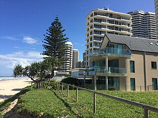
Main Beach is a coastal suburb of the City of Gold Coast, Queensland, Australia. At the 2016 census, Main Beach had a population of 3,883.

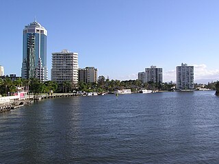
Southport is a coastal suburb in the City of Gold Coast, Queensland, Australia. In the 2016 census, Southport had a population of 31,908 people. It contains the Gold Coast central business district.

The Gold Coast Broadwater, also known as Southport Broadwater, Gold Coast Harbour and The Broadwater, is a large shallow estuary of water located in the Gold Coast district of South East Queensland, Australia. The estuary reaches from the locality of Southport in the south, to the southern section of the UNESCO World Heritage Listed Moreton Bay in the north. Separated via the Seaway from the Coral Sea by a thin strip of land called Stradbroke Island, the original body of water was a lagoon created from water deposited from the Nerang River. Part of the Broadwater is contained within the Moreton Bay Marine Park.

The Spit is a spit and neighbourhood within the northern end of Main Beach, City of Gold Coast, Queensland, Australia. It is a permanent sand spit that separates the Southport Broadwater from the Pacific Ocean.
The Gold Coast Shoreline Management Plan (GCSMP) is an ICZM plan to manage the coastal resources of City of Gold Coast. The EPA encourages the City Council's to produce shoreline management plans for coastlines and tidal waterways within the local authority area.
Narrow Neck is the name of an isthmus that separates the anabranch of the Nerang River from the southern end of Main Beach and the northern end of Surfers Paradise beach.
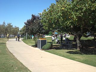
The Southport Broadwater Parklands is a large community park located in Southport. It is designed for large community gatherings and families. The park has many different areas for children and barbecue areas for families. The park went through a major redevelopment and was re-opened by the Premier of Queensland, Anna Bligh, on 23 August 2009. Southport Broadwater Parklands has become a popular family attraction.

Ferry Road is a road in Southport, on the Gold Coast, Queensland, Australia. Originally a suburban street, it is now part of Southport – Burleigh Road, a state controlled road
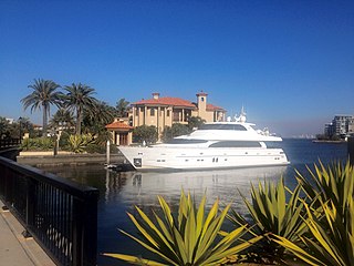
Sovereign Islands are an island group in the Southport Broadwater in southern Moreton Bay within the suburb of Paradise Point in the City of Gold Coast, Queensland, Australia. They were formed by a canal real estate development of the former Andys Island and Griffin Island.

South Passage is channel between the South Pacific Ocean and Moreton Bay. The other entrances to the bay are the North Passage and Jumpinpin Channel in the south.

Cavill Avenue is a street and a pedestrian mall in Surfers Paradise, Gold Coast, Queensland, Australia. It is in the heart of the Surfers Paradise shopping and entertainment district. It was named in honour of the man credited as the founder of Surfers Paradise, James Cavill, known as Jim Cavill.
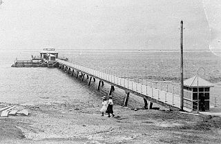
Southport Pier is a pier spanning the Gold Coast Broadwater in Southport, a suburb on the Gold Coast in South East Queensland, Australia. The current pier was constructed in 2009, replacing a previous structure demolished in 1969.
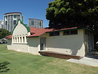
Southport Bathing Pavilion is a heritage-listed changing rooms at Marine Parade, Southport, Gold Coast City, Queensland, Australia. It was designed by Hall & Phillips and built in 1934 by A. Ledbury. It was added to the Queensland Heritage Register on 13 January 1995.

Humphreys Boat Shed was a heritage-listed workshop and slipway at Seaworld Drive, Main Beach, Queensland, Australia. It was added to the Queensland Heritage Register on 31 August 2001, but was removed in June 2015 having been destroyed. However the remnants of the boat shed and slipway are listed on the Gold Coast Local Heritage Register.

The Chevron Island is an urban island that lies in the Nerang River and is a neighbourhood within the suburb of Surfers Paradise in the City of Gold Coast, Queensland, Australia.

