The Gold Coast Shoreline Management Plan (GCSMP) is an ICZM plan to manage the coastal resources of City of Gold Coast. The EPA encourages the City Council's to produce shoreline management plans for coastlines and tidal waterways within the local authority area.
The Council commenced work on the GCSMP in 2005. [1] The previous key planning document for Gold Coast beaches was the Delft Report of 1971.
Gold Coast Beaches have had periods of severe beach erosion. In 1967, a series of eleven cyclones removed most of the sand from Gold Coast beaches. The Government of Queensland engaged engineers from Delft University in the Netherlands to advise what to do about the beach erosion. The Delft Report was published in 1971, and outlined a series of works for Gold Coast Beaches including Gold Coast Seaway, works at Narrowneck that resulted in the Northern Gold Coast Beach Protection Strategy and works at the Tweed River that became the Tweed River Entrance Sand Bypassing Project. [2] [3] [4] [5]
The Gold Coast seawall in Australia is contained within the Gold Coast's shoreline management plan. The original seawall was laid out following 11 cyclones in 1967 with assistance from coastal engineers from Delft University. The seawall alignment was selected to pick up as many of the older seawalls as possible. The seawall consists of three layers, armour boulders up to 4 tonnes, secondary armour around 360 kg and a clay shale foundation layer. The seawall is 16m across and 6m high and has a front slope of 1:1.5. The seawall was tested in a wave tank to withstand attack from a 1:100 cyclone wave.
A Gold Coast Seawall costs around A$3000 per meter to construct in 2006. The seawall is constructed along a designated seawall alignment along urban sections of the Gold Coast coastline. Non-Urban sections of coastline including South Stradbroke Island and the Southport Spit are not licensed for the construction of a seawall. The Gold Coast Planning Scheme requires private property owners along the beach to construct the seawall at their property at the property owners expense prior to making any investment into their house. The Council constructs sections of seawall that protect public land.
The Delft report recommended the stabilisation of the Gold Coast Seaway and the construction of a sand bypass system to pump sand from the mainland under the navigation channel to South Stradbroke Island. The GCSMP will examine whether 20% of the sand could instead be backpassed sustainably to the beaches of Surfers Paradise to mitigate the impact of climate change.
Prior to stabilisation of the Gold Coast Seaway the island welding hypothesis suggests that up to 20% of all sand moving along the Gold Coast (Longshore drift) entered the Gold Coast Broadwater to gradually weld islands onto the mainland.
In 1971 the Dutch University Delft completed a report for the Queensland State Government recommending the construction of a groyne at Narrowneck. The Council examined the idea of a groyne and instead constructed an artificial reef to stabilise the foreshore at Narrowneck. So far the reef has worked well as a coastal control point, but has been disappointing in its secondary objective to improve surfing. A surprising benefit of the Narrowneck Reef has been its ability to attract marine growth and reef fish and is now a popular diving and fishing location. Narrowneck is particularly popular for kite surfing and longboarding.
The Narrowneck Reef was constructed as a coastal control point 1/3 of the way between Burleigh Heads and the Gold Coast Seaway. The GCSMP will examine if a new reef at Kurrawa Park should be constructed at the 2/3s position to assist with the adaption of Gold Coast beaches to climate change.
In 2004 Gold Coast City Council proposed a new beach protection scheme for Palm Beach which included a new reef for 21st Avenue Palm Beach. The proposed scheme included 3 reefs and beach nourishment. Some in the community didn't like the idea and organised a "no reef" protest campaign that prevented the scheme being implemented.
Council dredges Currumbin Creek each year.
The Southern Points of the Gold Coast are northern facing and provide spectacular coastal vistas and great surf.
A popular surfing site, surfers are concerned that sand is drowning quality surf, but there is debate about the objectivity of perception of impacts. Council is undertaking nourishment of the foreshore to bury the seawall to increase the amount of recreational parkland.
Surfing waves break along a sand bank that extends from Snapper Rocks through Rainbow Bay, past Greenmount point and Coolangatta, then to Kirra. This region has been called the Superbank.
Surfers lobbied to have the sand outlet moved to improve the Surf at Snapper Rocks
A sand bypassing system commenced operating to deliver sand across the Tweed River from New South Wales to Queensland in 2001.
The Gold Coast Oceanway is a 36 kilometres (22 mi) network of pathways along Gold Coast beaches that encourages healthier and more sustainable coastal lifestyles.

The Gold Coast is a coastal city in the Australian state of Queensland, approximately 66 kilometres (41 mi) south-southeast of the centre of state capital Brisbane and immediately north of the border with New South Wales. The demonym for the Gold Coast is Gold Coaster. With an estimated population of 679,127, at June 2019, the Gold Coast is the sixth-largest city in Australia, making it the largest non-capital city, and Queensland's second-largest city.

Coastal erosion is the loss or displacement of land, or the long-term removal of sediment and rocks along the coastline due to the action of waves, currents, tides, wind-driven water, waterborne ice, or other impacts of storms. The landward retreat of the shoreline can be measured and described over a temporal scale of tides, seasons, and other short-term cyclic processes. Coastal erosion may be caused by hydraulic action, abrasion, impact and corrosion by wind and water, and other forces, natural or unnatural.
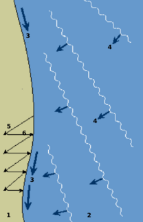
Longshore drift from longshore current is a geological process that consists of the transportation of sediments along a coast parallel to the shoreline, which is dependent on oblique incoming wave direction. Oblique incoming wind squeezes water along the coast, and so generates a water current which moves parallel to the coast. Longshore drift is simply the sediment moved by the longshore current. This current and sediment movement occur within the surf zone.

A groyne, built perpendicular to the shore, is a rigid hydraulic structure built from an ocean shore or from a bank that interrupts water flow and limits the movement of sediment. It is usually made out of wood, concrete, or stone. In the ocean, groynes create beaches, prevent beach erosion caused by longshore drift where this is the dominant process and facilitate beach nourishment. There is also often cross-shore movement which if longer than the groyne will limit its effectiveness.

The Tweed River is a river situated in the Northern Rivers district of New South Wales, Australia. It has a mature wave dominated, barrier estuary. From the middle reaches of its course, the state boundary between New South Wales and Queensland is located approximately 10 kilometres (6.2 mi) north of the Tweed River.
Beach nourishment describes a process by which sediment, usually sand, lost through longshore drift or erosion is replaced from other sources. A wider beach can reduce storm damage to coastal structures by dissipating energy across the surf zone, protecting upland structures and infrastructure from storm surges, tsunamis and unusually high tides. Beach nourishment is typically part of a larger Integrated coastal zone management aimed at coastal defense. Nourishment is typically a repetitive process since it does not remove the physical forces that cause erosion but simply mitigates their effects.

A seawall is a form of coastal defence constructed where the sea, and associated coastal processes, impact directly upon the landforms of the coast. The purpose of a sea wall is to protect areas of human habitation, conservation and leisure activities from the action of tides, waves, or tsunamis. As a seawall is a static feature it will conflict with the dynamic nature of the coast and impede the exchange of sediment between land and sea. The shoreline is part of the coastal interface which is exposed to a wide range of erosional processes arising from flowing water sources, wind and terrestrial sources, meaning that a combination of denudational processes will work against a seawall.

Palm Beach is a coastal suburb in the City of Gold Coast, Queensland, Australia. In the 2016 census, Palm Beach had a population of 14,654 people.

The Gold Coast Seaway or Southport Seaway is the main navigation entrance from the Pacific Ocean into the Gold Coast Broadwater and southern Moreton Bay and is one of Australia's most significant coastal engineering projects. It is located at the northern end of the Southport Spit where the Nerang River enters the Pacific Ocean. The channel was constructed between 1984 and 1986, primarily to facilitate the safe passage of sea-faring vessels. The passage was previously known as the Southport Bar. The mouth of the Nerang River was once located further south in Broadbeach. The main driving force for this movement is the northward drift of sand along the coast. This northward drift was responsible for the unstable and shifting conditions of the bar, which made crossing it so hazardous for small boats. The southern training wall of the Gold Coast Seaway is the northern end of the Gold Coast Oceanway.

Coastal management is defence against flooding and erosion, and techniques that stop erosion to claim lands. Protection against rising sea levels in the 21st century is crucial, as sea level rise accelerates due to climate change. Changes in sea level damage beaches and coastal systems are expected to rise at an increasing rate, causing coastal sediments to be disturbed by tidal energy.

The Spit is a spit and neighbourhood within the northern end of Main Beach, City of Gold Coast, Queensland, Australia. It is a permanent sand spit that separates the Southport Broadwater from the Pacific Ocean.

Kirra is a beach-side neighbourhood within the suburb of Coolangatta in the City of Gold Coast, Queensland, Australia.

Snapper Rocks is a small rocky outcrop on the northern side of Point Danger at the southern end of Rainbow Bay on the Gold Coast, Queensland, Australia. It is a famous surf break and today the start of the large sand bank known to surfers as the Superbank.
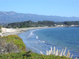
Goleta Beach is a region of coastline located near Goleta, California, just east of the University of California, Santa Barbara (UCSB) campus. A portion of the shore of Goleta Bay is managed by the County of Santa Barbara as Goleta Beach County Park —GBCP. The beach itself is partly man-made as sand was spread onto an existing sandspit in 1945. The beach is a seasonal habitat for migrating shorebirds including the snowy plover, an endangered species. The beach is occasionally closed due to nourishment efforts.
Beach evolution occurs at the shoreline where sea, lake or river water is eroding the land. Beaches exist where sand accumulated from centuries-old, recurrent processes that erode rocky and sedimentary material into sand deposits. River deltas deposit silt from upriver, accreting at the river's outlet to extend lake or ocean shorelines. Catastrophic events such as tsunamis, hurricanes, and storm surges accelerate beach erosion.
Narrow Neck is the name of an isthmus that separates the anabranch of the Nerang River from the southern end of Main Beach and the northern end of Surfers Paradise beach.

Totland Bay is a bay on the west coast of the Isle of Wight, England. It lies one-quarter of an mile (0.4 km) to the west of the village of Totland from which it takes its name. It faces north west and has a 2.5-mile-long (4.0 km) shoreline and is made up of a straight west facing coast which has a beach, concrete seawall, groynes and derelict 450-foot-long (140 m) Victorian pier and a straight north facing rocky coastline. It stretches from Warden Point in the north to Hatherwood Point in the south-west.
Seagrove Bay is a bay on the northeast coast of the Isle of Wight, England. It lies to the east of the village of Seaview facing towards Selsey Bill with a 2⁄3 mile (1.1 km) shoreline stretching from Nettlestone Point in the north to Horestone Point in the south. The bay has both the Seaside Award Flag and the Water Quality Award.

A surf break is a permanent obstruction such as a coral reef, rock, shoal, or headland that causes a wave to break, forming a barreling wave or other wave that can be surfed, before it eventually collapses. The topography of the seabed determines the shape of the wave and type of break. Since shoals can change size and location, affecting the break, it takes commitment and skill to find good breaks. Some surf breaks are quite dangerous, since the surfer can collide with a reef or rocks below the water.
A multi-purpose reef, also commonly known as an artificial surfing reef or surf reef, is a structure located offshore designed to induce wave breaking in a manner that creates a wave suitable for surfing or body boarding. Artificial surfing reefs can exist in many different configurations and be built from a variety of different materials. To date there have been fewer than ten attempts to build such a structure worldwide.