
Cunnamulla is a town and a locality in the Shire of Paroo, Queensland, Australia. It is 206 kilometres (128 mi) south of Charleville, and approximately 750 kilometres (470 mi) west of the state capital, Brisbane. In the 2016 census, Cunnamulla had a population of 1,140 people.

Thargomindah is a rural town and locality in the Shire of Bulloo, Queensland, Australia. The town of Thargomindah is the administrative centre for the Shire of Bulloo. In the 2016 census, Thargomindah had a population of 270 people. It was founded on Wongkumara and Kalali territory.

The Dawson Highway is a state highway in Queensland, Australia. It runs for 405 kilometres (252 mi) between Gladstone and Springsure where it terminates. From Gladstone to Rolleston it is signed as State Route 60, and then A7 onwards to Springsure. It continues west for another 247 kilometres (153 mi) as Dawson Developmental Road to Tambo on the Landsborough Highway. North of Springsure, A7 becomes the Gregory Highway.

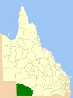
The Shire of Paroo is a local government area in South West Queensland, Australia. The administrative centre is the town of Cunnamulla. The Paroo Shire covers an area of 47,623 square kilometres (18,387 sq mi) and in June 2018 the area had a population of 1,586. Over the 12 months to June 2018, the Shire had the equal fastest rate of population decline in the state, -3.8 per cent.

Cameron Corner is an outback locality in the Shire of Bulloo, Queensland, Australia. In the 2016 census, Cameron Corner had a population of 5 people. It borders New South Wales to the south and South Australia to the west.

Noccundra is a rural town and locality in the Shire of Bulloo in South West Queensland, Australia. The town was previously known as Nocundra. Prior to 2020 the locality was previously known as Nockatunga.
The Shire of Bulloo is a local government area in South West Queensland, Australia.

Eulo is an outback town and locality in the Shire of Paroo, Queensland, Australia. In the 2016 census, Eulo had a population of 95 people. It is known for its opal mining.

South West Queensland is a remote region in the Australian state of Queensland which covers 319,808 km2 (123,479 sq mi). The region lies to the south of Central West Queensland and west of the Darling Downs and includes the Maranoa district and parts of the Channel Country. The area is noted for its cattle grazing, cotton farming, opal mining and oil and gas deposits.
Yowah is an outback town and locality in the Shire of Paroo, Queensland, Australia. In the 2016 census, Yowah had a population of 141 people.
Vincent James Dowling was an Australian explorer and pastoralist.

The Diamantina Developmental Road is a gazetted road in Queensland, Australia. that runs from Charleville in the south-central part of the state to Mount Isa in the north-west.

The Cooper Developmental Road is an outback road in Queensland, Australia. It is sometimes called the Cooper's Creek Developmental Road.
Durham is a rural locality in the Shire of Bulloo, Queensland, Australia. In the 2016 census Durham had a population of 36 people.
Bulloo Downs is a rural locality in the Shire of Bulloo, Queensland, Australia. In the 2016 census, Bulloo Downs had a population of 0 people.
Dynevor is a former locality in the Shire of Bulloo, Queensland, Australia. In the 2016 census, Dynevor had a population of 21 people.
The Adventure Way is an Australian outback route between Brisbane, Queensland and Innamincka, South Australia. Using the Adventure Way, it is 1,152 kilometres (716 mi) from Brisbane to Innamincka. The recommended journey time, allowing for some sightseeing, food and rest is 96 hours. It has been designated by the Queensland Government as a State Strategic Touring Route.
Bullawarra is a former locality in the Shire of Bulloo, Queensland, Australia. In the 2016 census, Bullawarra had a population of 5 people.
Richmond–Croydon Road is a continuous 360 kilometres (220 mi) road route in the Richmond, Croydon and Etheridge local government areas of Queensland, Australia. It is part of the shortest route from the Croydon / Georgetown area to Winton and Longreach. It is also part of the inland freight network linking cattle properties to major freight routes on the Landsborough and Flinders highways.
Cloncurry–Dajarra Road is a continuous 169 kilometres (105 mi) road route in the Cloncurry local government area of Queensland, Australia. It is a state-controlled district road rated as a local road of regional significance (LRRS). It is a north-east to south-west link between the Barkly Highway and the Diamantina Developmental Road, servicing a number of cattle grazing and production areas in northern Queensland.

