Norley, Queensland

Last updated

Norley
Queensland
Aerial view of Norley Station, June 1946.jpg
Aerial view of Norley Station, June 1946
Australia Queensland location map.svg
Red pog.svg
Norley
Coordinates 27°41′11″S143°45′08″E / 27.6865°S 143.7523°E / -27.6865; 143.7523 (Norley (centre of locality)) Coordinates: 27°41′11″S143°45′08″E / 27.6865°S 143.7523°E / -27.6865; 143.7523 (Norley (centre of locality))
Population0 (2016 census) [1]
 • Density0.00000/km2 (0.00000/sq mi)
Postcode(s) 4492
Area4,449.0 km2 (1,717.8 sq mi)
Time zone AEST (UTC+10:00)
Location
LGA(s) Shire of Bulloo
State electorate(s) Warrego
Federal Division(s) Maranoa
Suburbs around Norley:
Eromanga Quilpie Quilpie
Nockatunga Norley Yowah
Bullawarra Thargomindah Dynevor

Norley is a former locality in the Shire of Bulloo, Queensland, Australia. [2] In the 2016 census, Norley had a population of 0 people. [1]

Contents

On 17 April 2020 the Queensland Government reorganised the nine localities in the Shire, resulting in six localities. This included the discontinuation of Norley, absorbing all of its land into an enlarged Thargomindah. [3] [4] [5]

Geography

Norley was part of the Channel Country, a network of interconnecting creeks and rivers that are normally dry except during seasonal flooding. The land was used for low density cattle grazing.

The Bundeena Road entered the locality from the west and exited to the south to neighbouring Thargomindah. The Quilpie Thargomindah Road entered the locality from the north-east and exited to the south to Thargomindah. [6]

History

The locality of Norley took its name from its county and parish of the same name. The county name takes its name in turn from the Norley pastoral station. [7]

In the 2016 census, Norley had a population of 0 people. [1]

On 17 April 2020 the Queensland Government reorganised the nine localities in the Shire, resulting in six localities. This included the discontinuation of Norley, absorbing all of its land into an enlarged Thargomindah. [3] [4] [5]

Related Research Articles

Quilpie, Queensland Town in Queensland, Australia

Quilpie is a rural town and locality in the Shire of Quilpie, Queensland, Australia. In the 2016 census, Quilpie had a population of 595 people.

Thargomindah Town in Queensland, Australia

Thargomindah is a town and a locality in the Shire of Bulloo, Queensland, Australia. At the 2016 census, Thargomindah had a population of 270. It was founded on Wongkumara and Kalali territory.

Shire of Paroo Local government area in Queensland, Australia

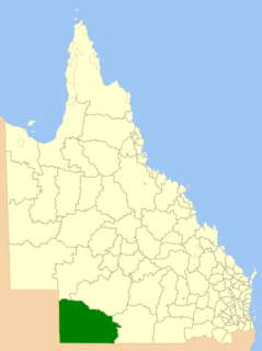
The Shire of Paroo is a local government area in South West Queensland, Australia. The administrative centre is the town of Cunnamulla. The Paroo Shire covers an area of 47,623 square kilometres (18,387 sq mi) and in June 2018 the area had a population of 1,586. Over the 12 months to June 2018, the Shire had the equal fastest rate of population decline in the state, -3.8 per cent.

Cameron Corner, Queensland Suburb of Bulloo Shire, Queensland, Australia

Cameron Corner is a rural locality in the Shire of Bulloo, Queensland, Australia. In the 2016 census, Cameron Corner had a population of 5 people.

Noccundra Town in Queensland, Australia

Noccundra is a rural town and locality in the Shire of Bulloo in South West Queensland, Australia. The town was previously known as Nocundra. Prior to 2020 the locality was previously known as Nockatunga.

Shire of Quilpie Local government area in Queensland, Australia

The Shire of Quilpie is a local government area in South West Queensland, Australia. It covers an area of 67,415 square kilometres (26,029 sq mi), and its administrative centre is the town of Quilpie.

Shire of Bulloo Local government area in Queensland, Australia

The Shire of Bulloo is a local government area in South West Queensland, Australia.

Eulo, Queensland Town in Queensland, Australia

Eulo is an opal-mining town and locality in the Shire of Paroo in South West Queensland, Australia. Eulo is 64 kilometres (40 mi) west of Cunnamulla and 887 kilometres (551 mi) west of Brisbane.

Hungerford, Queensland Town in Queensland, Australia

Hungerford is an outback town in the Shire of Bulloo and a locality in the Shire of Bulloo and Shire of Paroo, South West Queensland, Australia. It is immediately north of the border with New South Wales and the Dingo fence. At the 2016 census, Hungerford and the surrounding area within Queensland had a population of 23. The locality of Hungerford on the New South Wales side of the border had a population of 15.

Kalali is a poorly attested Australian Aboriginal language. It is one of several geographically transitional 'Karna–Mari fringe' languages that have not been convincingly classified, and is best considered an isolate branch within the Pama–Nyungan family. Gavan Breen provisionally includes Minkabari and the 'Ngura' dialect Pitjara/Bidjara/Bitharra, which together have been called the Bulloo River language.

Bollon, Queensland Town in Queensland, Australia

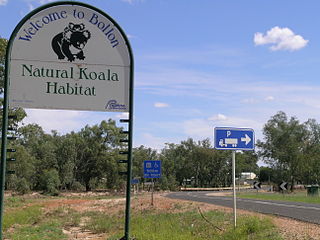
Bollon is a rural town and locality in the Shire of Balonne, Queensland, Australia. In the 2016 census, Bollon had a population of 221 people.

Barcaldine Region Local government area in Queensland, Australia

The Barcaldine Region is a local government area in Central West Queensland, Australia. Established in 2008, it was preceded by three previous local government areas which had existed for over a century.

Bulloo River river in Queensland, Australia

The Bulloo RiverBUUL-oo is an isolated drainage system in western Queensland, central Australia. Its floodplain, which extends into northern New South Wales, is an important area for waterbirds when inundated. It comprises most of the Bulloo-Bancannia drainage basin.

South West Queensland Region in Queensland, Australia

South West Queensland is a remote region in the Australian state of Queensland which covers 319,808 km2 (123,479 sq mi). The region lies to the south of Central West Queensland and west of the Darling Downs and includes the Maranoa district and parts of the Channel Country. The area is noted for its cattle grazing, cotton farming, opal mining and oil and gas deposits.

Bulloo Downs, Queensland Suburb of Shire of Bulloo, Queensland, Australia

Bulloo Downs is a rural locality in the Shire of Bulloo, Queensland, Australia. In the 2016 census, Bulloo Downs had a population of 0 people.

Dynevor, Queensland Suburb of Shire of Bulloo, Queensland, Australia

Dynevor is a former locality in the Shire of Bulloo, Queensland, Australia. In the 2016 census, Dynevor had a population of 21 people.

Bullawarra Suburb of Shire of Bulloo, Queensland, Australia

Bullawarra is a former locality in the Shire of Bulloo, Queensland, Australia. In the 2016 census, Bullawarra had a population of 5 people.

Cheepie, Queensland Town in Queensland, Australia

Cheepie is a town in the locality of Adavale in Shire of Quilpie, Queensland, Australia.

Bucca, Queensland Suburb of Bundaberg Region, Queensland, Australia

Bucca is a rural locality in the Bundaberg Region, Queensland, Australia. In the 2016 census, Bucca had a population of 1,027 people. The neighbourhood of Kolan is within the locality.

Barcaldine Downs Suburb of Barcaldine Region, Queensland, Australia

Barcaldine Downs is a former rural locality in the Barcaldine Region, Queensland, Australia. In the 2016 census, Barcaldine Downs had a population of 14 people.

References

  1. 1 2 3 Australian Bureau of Statistics (27 June 2017). "Norley (SSC)". 2016 Census QuickStats. Retrieved 20 October 2018. OOjs UI icon edit-ltr-progressive.svg
  2. "Norley - locality in Shire of Bulloo (entry 42948)". Queensland Place Names. Queensland Government . Retrieved 1 August 2017.
  3. 1 2 "Job number 19-068: Bullawarra, Bulloo Downs, Cameron Corner, Dynevor, Noccundra, Nockatunga, Norley, Thargomindah". Recent place name decisions. Queensland Government. 17 April 2020. Archived from the original on 23 April 2020. Retrieved 28 June 2020.
  4. 1 2 "Proposed Locality names and boundaries for the Shire of Bulloo" (PDF) (Map). Queensland Government. 22 November 2019. Archived from the original (PDF) on 23 April 2020. Retrieved 28 June 2020.
  5. 1 2 "Locality names and boundaries for the Shire of Bulloo" (PDF) (Map). Queensland Government. 17 April 2020. Archived from the original (PDF) on 23 April 2020. Retrieved 28 June 2020.
  6. "Queensland Globe". State of Queensland . Retrieved 1 August 2017.
  7. "Norley - county (entry 24528)". Queensland Place Names. Queensland Government . Retrieved 1 August 2017.

Commons-logo.svg Media related to Norley, Queensland at Wikimedia Commons