Bulloo Downs, Queensland

Last updated

Bulloo Downs
Queensland
Bulla or Koorliatto, view from the camp up and down the Creek, by Hermann Beckler, 1861.tif
Sketch of Bulloo River area near the Kooliatto Waterhole, 1861 by Hermman Beckler, member of the Burke and Wills expedition
Australia Queensland location map.svg
Red pog.svg
Bulloo Downs
Coordinates 28°36′08″S142°48′44″E / 28.6023°S 142.8123°E / -28.6023; 142.8123 (Bulloo Downs (centre of locality))
Population0 (2021 census) [1]
 • Density0.00000/km2 (0.00000/sq mi)
Postcode(s) 4492
Elevation93 m (305 ft)
Area11,252.1 km2 (4,344.5 sq mi)
Time zone AEST (UTC+10:00)
Location
LGA(s) Shire of Bulloo
State electorate(s) Warrego
Federal division(s) Maranoa
Suburbs around Bulloo Downs:
Noccundra Thargomindah Thargomindah
Cameron Corner Bulloo Downs Hungerford
Tibooburra (NSW) Wanaaring (NSW) Wanaaring (NSW)

Bulloo Downs is a rural locality in the Shire of Bulloo, Queensland, Australia. [2] It is on the Queensland border with New South Wales. [3] In the 2021 census, Bulloo Downs had "no people or a very low population". [1]

Contents

On 17 April 2020 the Queensland Government reorganized the nine localities in the Shire, resulting in six localities. It included Bulloo Downs losing a portion of its western land to the locality of Cameron Corner while gaining a small portion from the south of the former Bullawarra (the rest being incorporated into Thargomindah). [4] [5] [6] The area of Bulloo Downs decreased from 12,814.6 square kilometres (4,947.7 sq mi) to 11,252.1 square kilometres (4,344.5 sq mi). [3]

History

One group of the Burke and Wills expedition camped in Bulloo Downs in 1861; three men from the group died and were buried there. This expedition provided information about the suitability of the land for pastoral purposes and the first recorded settlement was Bulloo Downs Station taken up by Jones, Sullivan and Molesworth Green in 1864. [7]

The locality takes its name from the Bulloo Downs Station. Bulloo is an Aboriginal word from the Kamilaroi language meaning slow. [2]

On 17 April 2020 the Queensland Government reorganised the nine localities in the Shire, resulting in six localities. It included Bulloo Downs losing a small portion of its western land to the locality of Cameron Corner while gaining a small portion from the south of the former Bullawarra (the rest being incorporated into Thargomindah). [4] [5] [6]

Demographics

In the 2016 census, Bulloo Downs had "no people or a very low population". [8]

In the 2021 census, Bulloo Downs had "no people or a very low population". [1]

Heritage listings

Bulloo Downs has a number of heritage-listed sites, including:

Related Research Articles

<span class="mw-page-title-main">Quilpie, Queensland</span> Town in Queensland, Australia

Quilpie is a rural town and locality in the Shire of Quilpie, Queensland, Australia. In the 2021 census, the locality of Quilpie had a population of 530 people.

<span class="mw-page-title-main">Thargomindah</span> Town in Queensland, Australia

Thargomindah is a rural town and locality in the Shire of Bulloo, Queensland, Australia. The town of Thargomindah is the administrative centre for the Shire of Bulloo. In the 2021 census, the locality of Thargomindah had a population of 243 people.

<span class="mw-page-title-main">Shire of Paroo</span> Local government area in Queensland, Australia

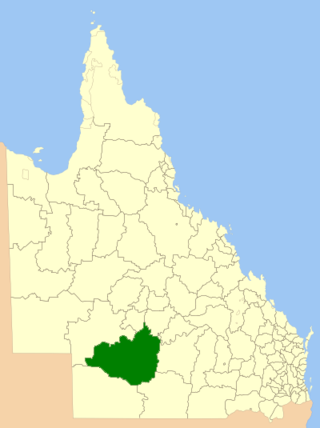
The Shire of Paroo is a local government area in South West Queensland, Australia. The administrative centre is the town of Cunnamulla. The Paroo Shire covers an area of 47,623 square kilometres (18,387 sq mi). In the 2021 census, the Shire of Paroo had a population of 1,679 people.

<span class="mw-page-title-main">Cameron Corner, Queensland</span> Suburb of Bulloo Shire, Queensland, Australia

Cameron Corner is an outback locality in the Shire of Bulloo, Queensland, Australia. It is on the Queensland border with New South Wales to the south and South Australia to the west. In the 2021 census, Cameron Corner had a population of 19 people.

<span class="mw-page-title-main">Haddon Corner</span> Historic site in Queensland, Australia

Haddon Corner is a heritage-listed site in Tanbar, Shire of Barcoo, Queensland, Australia. It is in outback Channel Country at South-West Queensland, on the border corner with South Australia. It was added to the Queensland Heritage Register on 9 November 2012.

<span class="mw-page-title-main">Noccundra</span> Town in Queensland, Australia

Noccundra is a rural town and locality in the Shire of Bulloo in South West Queensland, Australia. The town was previously known as Nocundra. Prior to 2020 the locality was previously known as Nockatunga.

<span class="mw-page-title-main">Shire of Quilpie</span> Local government area in Queensland, Australia

The Shire of Quilpie is a local government area in South West Queensland, Australia. It covers an area of 67,415 square kilometres (26,029 sq mi), and its administrative centre is the town of Quilpie.

<span class="mw-page-title-main">Shire of Bulloo</span> Local government area in Queensland, Australia

The Shire of Bulloo is a local government area in South West Queensland, Australia.

<span class="mw-page-title-main">Eulo, Queensland</span> Town in Queensland, Australia

Eulo is an outback town and locality in the Shire of Paroo, Queensland, Australia. It is known for its opal mining. In the 2021 census, the locality of Eulo had a population of 94 people.

<span class="mw-page-title-main">Hungerford, Queensland</span> Town in Queensland, Australia

Hungerford is an outback town in the Shire of Bulloo and a locality in the Shire of Bulloo and Shire of Paroo, South West Queensland, Australia. The locality is on the Queensland border with New South Wales.

<span class="mw-page-title-main">Central Highlands Region</span> Local government area in Queensland, Australia

Central Highlands Region is a local government area in Queensland, Australia. In the 2021 census, the Central Highlands Region had a population of 27,836 people.

<span class="mw-page-title-main">Bulloo River</span> River in Queensland, Australia

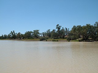
The Bulloo RiverBUUL-oo is an isolated drainage system in western Queensland, central Australia. Its floodplain, which extends into northern New South Wales, is an important area for waterbirds when inundated. It comprises most of the Bulloo-Bancannia drainage basin.

<span class="mw-page-title-main">South West Queensland</span> Region in Queensland, Australia

South West Queensland is a remote region in the Australian state of Queensland which covers 319,808 km2 (123,479 sq mi). The region lies to the south of Central West Queensland and west of the Darling Downs and includes the Maranoa district and parts of the Channel Country. The area is noted for its cattle grazing, cotton farming, opal mining and oil and gas deposits.

<span class="mw-page-title-main">Durham, Queensland</span> Suburb of Bulloo Shire, Queensland, Australia

Durham is a rural locality in the Shire of Bulloo, Queensland, Australia. It is on the Queensland border with South Australia. In the 2021 census, Durham had a population of 31 people.

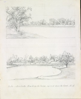
Dr Ludwig Becker's Grave is a heritage-listed grave at Molesworth Station, by the Bulloo River, Bulloo Downs, Shire of Bulloo, Queensland, Australia. He was buried in 1861. It was added to the Queensland Heritage Register on 5 August 1994.

<span class="mw-page-title-main">Tanbar, Queensland</span> Suburb of Shire of Barcoo, Queensland, Australia

Tanbar is an outback locality in the Shire of Barcoo, Queensland, Australia. It is on the corner of Queensland's southern and western border with South Australia. In the 2021 census, Tanbar had "no people or a very low population".

Dynevor is a former locality in the Shire of Bulloo, Queensland, Australia. In the 2016 census, Dynevor had a population of 21 people.

Bullawarra is a former locality in the Shire of Bulloo, Queensland, Australia. In the 2016 census, Bullawarra had a population of 5 people.

<span class="mw-page-title-main">Norley, Queensland</span> Suburb of Shire of Bulloo, Queensland, Australia

Norley is a former locality in the Shire of Bulloo, Queensland, Australia. In the 2016 census, Norley had "no people or a very low population".

<span class="mw-page-title-main">John Brewer Cameron</span>

John Brewer Cameron was a geodetic surveyor in Australia. He is best known for his survey of the border between Queensland and New South Wales. He also surveyed part of the border between South Australia and Western Australia.

References

  1. 1 2 3 Australian Bureau of Statistics (28 June 2022). "Bulloo Downs (SAL)". 2021 Census QuickStats. Retrieved 28 February 2023. OOjs UI icon edit-ltr-progressive.svg
  2. 1 2 "Bulloo Downs – locality in Shire of Bulloo (entry 42942)". Queensland Place Names. Queensland Government . Retrieved 6 September 2016.
  3. 1 2 "Queensland Globe". State of Queensland . Retrieved 28 December 2023.
  4. 1 2 "Job number 19-068: Bullawarra, Bulloo Downs, Cameron Corner, Dynevor, Noccundra, Nockatunga, Norley, Thargomindah". Recent place name decisions. Queensland Government. 17 April 2020. Archived from the original on 23 April 2020. Retrieved 28 June 2020.
  5. 1 2 "Proposed Locality names and boundaries for the Shire of Bulloo" (PDF) (Map). Queensland Government. 22 November 2019. Archived from the original (PDF) on 23 April 2020. Retrieved 28 June 2020.
  6. 1 2 "Locality names and boundaries for the Shire of Bulloo" (PDF) (Map). Queensland Government. 17 April 2020. Archived from the original (PDF) on 23 April 2020. Retrieved 28 June 2020.
  7. 1 2 "Dr Ludwig Becker's Grave (entry 601359)". Queensland Heritage Register . Queensland Heritage Council. Retrieved 7 July 2013.
  8. Australian Bureau of Statistics (27 June 2017). "Bulloo Downs (SSC)". 2016 Census QuickStats. Retrieved 20 October 2018. OOjs UI icon edit-ltr-progressive.svg

Commons-logo.svg Media related to Bulloo Downs, Queensland at Wikimedia Commons