Dynevor, Queensland

Last updated

Dynevor
Queensland
Australia Queensland location map.svg
Red pog.svg
Dynevor
Coordinates 28°12′34″S144°11′54″E / 28.2094°S 144.1983°E / -28.2094; 144.1983 (Dynevor (centre of locality))
Population21 (2016 census) [1]
 • Density0.00365/km2 (0.00944/sq mi)
Postcode(s) 4492
Area5,758.9 km2 (2,223.5 sq mi)
Time zone AEST (UTC+10:00)
Location
LGA(s) Shire of Bulloo
State electorate(s) Warrego
Federal division(s) Maranoa
Suburbs around Dynevor:
Thargomindah Norley Yowah
Bullawarra Dynevor Eulo
Buloo Downs Hungerford Hungerford

Dynevor is a former locality in the Shire of Bulloo, Queensland, Australia. [2] In the 2016 census, Dynevor had a population of 21 people. [1]

Contents

On 17 April 2020 the Queensland Government reorganised the nine localities in the Shire of Bulloo, resulting in six localities. This included discontinuing Dynevor, incorporating its land into an enlarged locality of Thargomindah. [3] [4] [5]

Geography

Dynevor was in the Channel Country. It was arid land, mostly flat and approximately 150 metres above sea level. Although there was a network of mostly unnamed creeks through the locality, these were usually dry creek beds. An area of higher land (about 200 metres above sea level) ran north to south through the locality, resulting in the creeks in the west of the locality forming part of the Bulloo River drainage basin and in the east of the locality forming part of the Paroo River drainage basin. [6]

The land was predominantly leased for pastoral purposes, the northern part of the locality being the Dynevor Downs pastoral lease (and presumably the source of the locality name). The north-west part of the locality contained the entire Lake Bindegolly National Park while a portion of the Currawinya National Park could be found in the north-east although the bulk of that national park was in adjacent Hungerford. [6]

The Cunnamulla Road (also known as the Bulloo Developmental Road and the Adventure Way) from Thargomindah to Cunnamulla passed from west to east through the northern part of the locality. The Hungerford Road from Thargomindah to Hungerford passed from north to south through the western part of the locality. [6]

There was no town in the locality but the town of Thargomindah was only 1 km from the locality's north-west boundary and the town of Yowah was 4 km from the locality's north-east boundary. The Dynevor Downs Homestead is located on the Cunnamulla Road ( 28°05′46″S144°21′53″E / 28.0960°S 144.3648°E / -28.0960; 144.3648 ) and has the Dynevor Downs Airport ( ICAO : YDNV) with three runways (north-south, east-west, and NE-SW), the longest being 1050 metres, the others being about 800 metres. [6] [7]

History

Margany (also known as Marganj, Mardigan, Marukanji, Maranganji) is an Australian Aboriginal language spoken by the Margany people. The Margany language region includes the landscape within the local government boundaries of the Quilpie Shire, taking in Quilpie, Cheepie and Beechal extending towards Eulo and Thargomindah, as well as the properties of Dynevor Downs and Ardoch. [8]

In the 2016 census, Dynevor had a population of 21 people. [1]

Related Research Articles

<span class="mw-page-title-main">Cunnamulla</span> Town in Queensland, Australia

Cunnamulla is a town and a locality in the Shire of Paroo, Queensland, Australia. It is 206 kilometres (128 mi) south of Charleville, and approximately 750 kilometres (470 mi) west of the state capital, Brisbane. In the 2021 census, Cunnamulla had a population of 1,233 people.

<span class="mw-page-title-main">Quilpie, Queensland</span> Town in Queensland, Australia

Quilpie is a rural town and locality in the Shire of Quilpie, Queensland, Australia. In the 2021 census, the locality of Quilpie had a population of 530 people.

<span class="mw-page-title-main">Thargomindah</span> Town in Queensland, Australia

Thargomindah is a rural town and locality in the Shire of Bulloo, Queensland, Australia. The town of Thargomindah is the administrative centre for the Shire of Bulloo. In the 2016 census, Thargomindah had a population of 270 people. It was founded on Wongkumara and Kalali territory.

<span class="mw-page-title-main">Warrego River</span> River in Australia

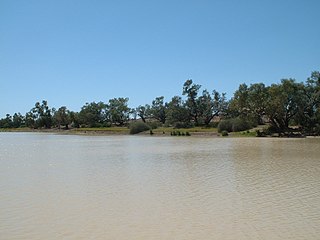
The Warrego River is an intermittent river that is part of the Darling catchment within the Murray–Darling basin, which is located in South West Queensland and in the Orana region of New South Wales, Australia. The Warrego River is the northernmost tributary of the Darling River.

<span class="mw-page-title-main">Shire of Paroo</span> Local government area in Queensland, Australia

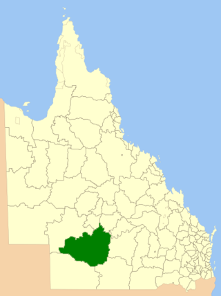
The Shire of Paroo is a local government area in South West Queensland, Australia. The administrative centre is the town of Cunnamulla. The Paroo Shire covers an area of 47,623 square kilometres (18,387 sq mi). In the 2021 census, the Shire had a population of 1,679.

<span class="mw-page-title-main">Cameron Corner, Queensland</span> Suburb of Bulloo Shire, Queensland, Australia

Cameron Corner is an outback locality in the Shire of Bulloo, Queensland, Australia. In the 2016 census, Cameron Corner had a population of 5 people. It is on the Queensland border with New South Wales to the south and South Australia to the west.

<span class="mw-page-title-main">Noccundra</span> Town in Queensland, Australia

Noccundra is a rural town and locality in the Shire of Bulloo in South West Queensland, Australia. The town was previously known as Nocundra. Prior to 2020 the locality was previously known as Nockatunga.

<span class="mw-page-title-main">Shire of Quilpie</span> Local government area in Queensland, Australia

The Shire of Quilpie is a local government area in South West Queensland, Australia. It covers an area of 67,415 square kilometres (26,029 sq mi), and its administrative centre is the town of Quilpie.

<span class="mw-page-title-main">Shire of Bulloo</span> Local government area in Queensland, Australia

The Shire of Bulloo is a local government area in South West Queensland, Australia.

<span class="mw-page-title-main">Eulo, Queensland</span> Town in Queensland, Australia

Eulo is an outback town and locality in the Shire of Paroo, Queensland, Australia. In the 2016 census, Eulo had a population of 95 people. It is known for its opal mining.

<span class="mw-page-title-main">Hungerford, Queensland</span> Town in Queensland, Australia

Hungerford is an outback town in the Shire of Bulloo and a locality in the Shire of Bulloo and Shire of Paroo, South West Queensland, Australia. The locality is on the Queensland border with New South Wales.

<span class="mw-page-title-main">Bulloo River</span> River in Queensland, Australia

The Bulloo RiverBUUL-oo is an isolated drainage system in western Queensland, central Australia. Its floodplain, which extends into northern New South Wales, is an important area for waterbirds when inundated. It comprises most of the Bulloo-Bancannia drainage basin.

Adavale is a rural town and locality in the Shire of Quilpie, Queensland, Australia. In the 2016 census, the locality of Adavale had a population of 93 people. By 2021, the population was down to 72.

<span class="mw-page-title-main">South West Queensland</span> Region in Queensland, Australia

South West Queensland is a remote region in the Australian state of Queensland which covers 319,808 km2 (123,479 sq mi). The region lies to the south of Central West Queensland and west of the Darling Downs and includes the Maranoa district and parts of the Channel Country. The area is noted for its cattle grazing, cotton farming, opal mining and oil and gas deposits.

<span class="mw-page-title-main">Bulloo Developmental Road</span> Road in Queensland, Australia

The Bulloo Developmental Road is an outback road in Queensland, Australia. It is part of the Adventure Way, a route from Brisbane to Adelaide via the Australian outback.

<span class="mw-page-title-main">Durham, Queensland</span> Suburb of Bulloo Shire, Queensland, Australia

Durham is a rural locality in the Shire of Bulloo, Queensland, Australia. It is on the Queensland border with South Australia. In the 2016 census Durham had a population of 36 people.

<span class="mw-page-title-main">Bulloo Downs, Queensland</span> Suburb of Shire of Bulloo, Queensland, Australia

Bulloo Downs is a rural locality in the Shire of Bulloo, Queensland, Australia. It is on the Queensland border with New South Wales. In the 2016 census, Bulloo Downs had a population of 0 people.

Bullawarra is a former locality in the Shire of Bulloo, Queensland, Australia. In the 2016 census, Bullawarra had a population of 5 people.

<span class="mw-page-title-main">Norley, Queensland</span> Suburb of Shire of Bulloo, Queensland, Australia

Norley is a former locality in the Shire of Bulloo, Queensland, Australia. In the 2016 census, Norley had a population of 0 people.

Cheepie is a town in the locality of Adavale in Shire of Quilpie, Queensland, Australia. It has a population of 2 people.

References

  1. 1 2 3 Australian Bureau of Statistics (27 June 2017). "Dynevor (SSC)". 2016 Census QuickStats. Retrieved 20 October 2018. OOjs UI icon edit-ltr-progressive.svg
  2. "Dynevor – locality (entry 49863)". Queensland Place Names. Queensland Government . Retrieved 27 May 2017.
  3. "Job number 19-068: Bullawarra, Bulloo Downs, Cameron Corner, Dynevor, Noccundra, Nockatunga, Norley, Thargomindah". Recent place name decisions. Queensland Government. 17 April 2020. Archived from the original on 23 April 2020. Retrieved 28 June 2020.
  4. "Proposed Locality names and boundaries for the Shire of Bulloo" (PDF) (Map). Queensland Government. 22 November 2019. Archived from the original (PDF) on 23 April 2020. Retrieved 28 June 2020.
  5. "Locality names and boundaries for the Shire of Bulloo" (PDF) (Map). Queensland Government. 17 April 2020. Archived from the original (PDF) on 23 April 2020. Retrieved 28 June 2020.
  6. 1 2 3 4 "Queensland Globe". State of Queensland . Retrieved 27 May 2017.
  7. "Dynevor Downs Airport" . Retrieved 27 May 2017.
  8. "Margany". State Library of Queensland . Retrieved 15 January 2020.