Eulo is 64 kilometres (40mi) west of Cunnamulla and 887 kilometres (551mi) west of Brisbane.
The town is located beside and to the east of the Paroo River which flows in a roughly north–south direction. This results in flooding events that affects people, livestock, and wildlife. With Cyclone Audrey in mid-January 1964, the town experienced 11 inches (280mm) of rain in one twenty-four hour period, which was double the previous record of 1887.[5] Former-Cyclone Dianne saw flood waters came south from Longreach, resulting in the Paroo breaching the town's levee on Saturday, 29 March 2025.[6] Occupants of only three houses were impacted, and sixty persons in the town otherwise unaffected.
Preferring barren, dry, rocky sites in only a few selected locations in Australia, the flowering Prostanthera megacalyx shrub can be found in the Eulo area.[7]
Vincent Dowling (1835–1903) began exploring in south west Queensland, tracing the Paroo and the Bulloo Rivers to their sources, and in 1861, established Caiwarroo and Eulo stations, and later a pastoral lease of Thargomindah.[9] The town takes its name from a settlement on the Paroo River first appearing on an 1872 map of Queensland map.[3]
The post office opened on 6 September 1872; the first postmaster was the publican William Shearer.[3][10]
A town reserve was proclaimed in 1874 described as "near the Eulo waterhole".[3]
A police station was established about 1 January 1880.[11]
A Court of Petty Sessions was established on 18 August 1880 and operated until 31 December 1964.[12]
By 1883, the Cobb and Co. mail and stage coach would leave Thargomindah on a Wednesday at 1:00 pm to arrive in Hungerford by 6:00 pm Friday; and from there leaving Sunday at 6:00 am, arriving in Eulo at 1:00 pm Monday, and back at Thargomindah by 1:00 pm Tuesday.[13] Stage coach driver Billy Chute (William Tuite) later went on to run the Gladstone Hotel with his wife Margaret.[14] The last Cobb and Co. coach ran in Australia in 1920.
The Eulo Provisional School opened on 7 May 1888. On 1 January 1909 it became the Eulo State School.[15][16]
Over time, there were a number of public hotels:[17]
Eulo Hotel (established 1868) with licensee (G)eorge Felix Davies.[17][18] The name was changed to the Royal Mail Hotel (c.1888), then the licence went to Richard Robinson and his wife Isabel Gray whence it was renamed as the Empire Hotel in May 1894,[19] before closing in 1898. Frank Hickling was also identified as a proprietor of the Empire in 1896.[20]
A robbery of the Empire Hotel occurred in May 1896 during a ball where the landlord's safe was removed, with over £50 cash and £20 of opals; with the offenders later arrested.[21]
The Empire Hotel was destroyed by fire, "burned to the ground", in January 1911.[22] Made from pise, the mud walls remained long afterwards.[23]
Isabel Gray, the Eulo Queen
Metropolitan Hotel (established 1888),[24] closed in December 1912, and allegedly destroyed by fire later on.[17]
By 1894 with Robinson at the Royal Mail Hotel, James Wheeler held the licence for the Metropolitan.[25] It was bought in 1912 by Isabel Gray and her husband Richard Robinson.[24][26] In the same year, the hotel's cook was very successful on a Melbourne Cup sweeps with £1000 (as of 2020, equivalent of A$125,000), such that within a few days she wed one of the "big gun fencers of the district".[27]
Gladstone Hotel (established 1900).[17] In 1894, the proprietor was James Kearney.[25] Another early licensee was John Frank Hickling (d. December 1898) and his wife Margaret Hickling.[28] Margaret continued on after the death of her husband.[29] William Henry Tuite (c.1878–1935; also called 'Billy Chute') and Margaret Tuite took over the Gladstone by 1928, where William had been a driver for the Cobb and Co. mail coaches for over 25 years.[14] In March 1937, the licence changed from Margaret Tuite to the gentleman and former manager of Tilboroo Station, Arthur Michael Patch.[30] He sold the hotel in June 1945.[31]
The hotel was destroyed by fire at 0:45 am, Monday, 10 October 1949.[32] It was described as a single-story wooden hotel, "a relic of the days of Cobb and Co." stage coaching. At the time there were twelve boarders and the licensee Mrs V. B. Prow.[33] As the last Eulo hotel, there was no bar for 100 miles (160km) between Thargomindah and Cunnamulla.[34] As a result in a town with 11 houses and 60 residents, a working bee created a temporary bar within days.[35]
The hotel was rebuilt and renamed as the Eulo Queen Hotel, on Leo Street.[17] Before the Prow licence, the licensee was W. Connolly.[36] At a time, Samuel Lovie was the publican, before moving south in 1958.[37] It was otherwise possibly originally established in 1886.[38]
There was some unfriendly rivalry between the hotels, when in early 1890, Isabel Gray had her substantial liquor holdings (£350; as of 2020, in excess of A$55,000) and furniture seized, upon information supplied by Hickling (formerly of the Gladstone and the Royal Mail), Kearney (of the Gladstone), and one other.[39] She had just purchased the Royal Mail Hotel from merchant R. Burke on 1 September 1889, where the furniture of former licensee Mr Julius was held by a bill-of-sale. Kearney was appointed as a trustee for the possible insolvency of Julius; but had a conflict of interest as a rival to Gray. The matter went before the court, where the confiscation order was annulled.[40]
Circa 1900, Thomas James Cooney (1873–1953) opened a small butchering business in Eulo, having worked the area as a blade shearer involved in the 1894 shearers strike, was an opal gouger, and undertook fence post cutting and kangaroo shooting to make a living.[41] The business and his family expanded, before going onto acquire several large sheep and cattle properties including Goonamurra, and Turn Turn (SW of Eulo).[42]
Saint Francis' Anglican Church was dedicated by Archbishop Reginald Halse on 15 September 1957. Its closure on 12 June 2010 was approved by Archbishop Phillip Aspinall.[44] A former Catholic church of Saint Joseph is beside Saint Francis. The first wedding celebrated at the church was that of the eldest son of butcher-cum-grazier Tom Cooney on 17 March 1929,[45] although that was subject to a decree nisi in October 1937.[46]
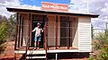
The town hosts an old World War II air raid shelter on Leo Street,[47] the town then being a communications link, and on the flight path from Darwin to Melbourne.[24]
The eastern entrance to the town has a statue of a diprotodon.[24]
Demographics
In the 2006 census, the locality of Eulo had a population of 108 people.[48]
In the 2016 census, the locality of Eulo had a population of 95 people.[49]
In the 2021 census, the locality of Eulo had a population of 94 people.[1]
Eulo has one public hotel and a small general store as well as fuel service station. The general store and fuel bowsers were destroyed by fire on 25 July 2011,[51] but since rebuilt.[52]
Immediately south of the town is the 2,000 metres (6,600ft) earthen runway airport (ICAO code YEUO). In 2023, the airstrip became the first Queensland town to test runway emergency lanterns that could be used by the Royal Flying Doctor Service for night-time call-outs.[53]
Education
Eulo State School is a government primary (Early childhood to Year 6) school for boys and girls on the southern corner of Leo Street and Emu Street (28°09′27″S145°03′01″E / 28.1575°S 145.0504°E / -28.1575; 145.0504 (Eulo State School)).[54][55] The enrolments between 2010 and 2012 have ranged from 11 to 16 students. In 2018, the school had an enrolment of 14 students with two teachers and four non-teaching staff (two full-time equivalent).[56] Some students travel up to 130 kilometres (81mi) each day to attend school, while other students live in the Eulo and District Hostel during the week in order to attend. After completing primary school in Eulo, there are no nearby secondary schools, so most students attend a secondary boarding school in Brisbane or Toowoomba.[57]
Events
Eulo lizard racing track, 2006
Eulo hosts an annual lizard racing championships on their Paroo Track every August/September,[58] which commenced in 1968, held in conjunction with the Cunnamulla and Eulo Opal Festival.[24]
The Eulo Polocrosse Club has an annual July event, and a motorbike gymkhana and enduro is conducted each Easter.[24]
The town was one of the stops in the March 2023 Shitbox Rally motoring event rally.
Notable residents
Isabel Gray (better known as the Eulo Queen) was a publican, storekeeper and prostitute[59]
↑ Rutledge, Martha. "Vincent James Dowling (1835–1903)". Australian Dictionary of Biography. Australian National Bibliography. Retrieved 18 January 2013.
↑ Premier Postal History. "Post Office List". Premier Postal Auctions. Retrieved 16 May 2014.
↑ "The Warrego". Dalby Herald and Western Queensland Advertiser. Vol.III, no.145. Queensland, Australia. 27 June 1868. p.3. Retrieved 4 April 2025– via National Library of Australia.
↑ "Current News". The Queenslander. Queensland, Australia. 5 May 1894. p.859. Retrieved 4 April 2025– via National Library of Australia.
↑ "Advertising". Worker. Vol.7, no.268. Queensland, Australia. 20 June 1896. p.13. Retrieved 4 April 2025– via National Library of Australia.
↑ "Queensland". Barrier Miner. Vol.9, no.2533. New South Wales, Australia. 29 May 1896. p.2. Retrieved 4 April 2025– via National Library of Australia.
↑ "Glimpses of country life". The Sydney Mail. Vol.XLVIII, no.1237. New South Wales, Australia. 11 December 1935. p.2. Retrieved 3 April 2025– via National Library of Australia.
↑ "Personal notes". The Queenslander. No.2733. Queensland, Australia. 18 January 1919. p.40. Retrieved 4 April 2025– via National Library of Australia.
↑ "Temporary bar built". Bundaberg News-Mail. No.13171. Queensland, Australia. 11 October 1949. p.1. Retrieved 4 April 2025– via National Library of Australia.
↑ "Cunnamulla". Balonne Beacon. Vol.44, no.50. Queensland, Australia. 9 December 1948. p.4. Retrieved 4 April 2025– via National Library of Australia.
↑ "Obituary". The Western Herald. New South Wales, Australia. 12 August 1960. p.8. Retrieved 4 April 2025– via National Library of Australia.
↑ "Sly Grog-selling". The Queenslander. Vol.XXXVII, no.752. Queensland, Australia. 1 March 1890. p.391. Retrieved 4 April 2025– via National Library of Australia.
↑ "Sly grog-selling". The Brisbane Courier. Vol.XLVI, no.10, 019. Queensland, Australia. 24 February 1890. p.3. Retrieved 4 April 2025– via National Library of Australia.
↑ "History". Eulo Queen Hotel. Archived from the original on 26 June 2014. Retrieved 16 May 2014.
↑ Anglican Church of Southern Queensland. "Closed Churches". Archived from the original on 3 April 2019. Retrieved 3 April 2019.
↑ "COONEY—M'CARTHY". The Brisbane Courier. No.22, 209. Queensland, Australia. 3 April 1929. p.22. Retrieved 4 April 2025– via National Library of Australia.
↑ "Old Bill's". Brisbane Telegraph. Queensland, Australia. 17 November 1951. p.1 (Last race). Retrieved 4 April 2025– via National Library of Australia.
↑ Gill, J. C. H. "Isabel Gray (1851–1929)". Gray, Isabel (1851–1929). National Centre for Biography, Australian National University. Archived from the original on 3 March 2017. Retrieved 16 May 2014.{{cite book}}: |work= ignored (help)
This page is based on this Wikipedia article Text is available under the CC BY-SA 4.0 license; additional terms may apply. Images, videos and audio are available under their respective licenses.


