The Birdsville Track is a notable outback road in Australia. The 517-kilometre (321 mi) track runs between Birdsville in south-western Queensland and Marree, a small town in the north-eastern part of South Australia. It traverses three deserts along the route, the Strzelecki Desert, Sturt Stony Desert and Tirari Desert.

Mitchell Highway is an outback state highway located in the central and south western regions of Queensland and the northern and central western regions of New South Wales in Australia. The southern part of Mitchell Highway forms part of the National Highway A32 B71 corridor, which stretches from Sydney to Brisbane via Dubbo. Mitchell Highway also forms part of the shortest route between Sydney and Darwin, via Bourke and Mount Isa, making it an important road link for the transport of passengers and freight for regional New South Wales and Queensland. The highway is a part of route Alternative A2 between Augathella and Charleville, route A71 and B71 between Charleville and Nyngan, and part of route A32 between Nyngan and Bathurst.

Eyre Highway is a 1,664-kilometre (1,034 mi) highway linking Western Australia and South Australia via the Nullarbor Plain. Signed as National Highways 1 and A1, it forms part of Highway 1 and the Australian National Highway network linking Perth and Adelaide. It was named after explorer Edward John Eyre, who was the first European to cross the Nullarbor by land, in 1840–1841. Eyre Highway runs from Norseman in Western Australia, past Eucla, to the state border. Continuing to the South Australian town of Ceduna, it crosses the top of the Eyre Peninsula before reaching Port Augusta.
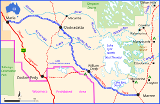
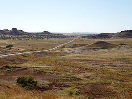
The Oodnadatta Track is an unsealed 614 km (382 mi) outback road in the Australian state of South Australia, connecting Marla in the north-west via Oodnadatta to Marree in the south-east. Along the way, the track passes the settlements of Oodnadatta and William Creek, the southern lake of the Kati Thanda-Lake Eyre National Park, and mound springs known as Freeling Springs, Strangways Springs, and The Bubbler and Blanche Cup.

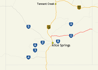
Stuart Highway is a major Australian highway. It runs from Darwin, in the Northern Territory, via Tennant Creek and Alice Springs, to Port Augusta in South Australia; a distance of 2,720 km (1,690 mi). Its northern and southern extremities are segments of Australia's Highway 1. The principal north–south route through the central interior of mainland Australia, the highway is often referred to simply as "The Track".

Great Northern Highway is an Australian highway that links Western Australia's capital city Perth with its northernmost port, Wyndham. With a length of almost 3,200 kilometres (2,000 mi), it is the longest highway in Australia, with the majority included as part of the Perth Darwin National Highway. The highway is constructed as a sealed, predominantly two-lane single carriageway, but with some single-lane bridges in the Kimberley. The Great Northern Highway travels through remote areas of the state, and is the only sealed road link between the Northern Territory and northern Western Australia. Economically, it provides vital access through the Wheatbelt and Mid West to the resource-rich regions of the Pilbara and Kimberley. In these areas, the key industries of mining, agriculture and pastoral stations, and tourism are all dependent on the highway.

The Barkly Highway is a national highway of both Queensland and the Northern Territory in Australia. It is the only sealed road between Queensland and the Northern Territory.

Landsborough Highway is a highway in western Queensland, Australia, running in the northwest–southeast direction from Morven to Cloncurry. The Landsborough Highway runs through vast tracts of land that was once occupied by William Landsborough, an Australian explorer of the 19th century. It is also the central part of the tourist route known as the Matilda Way after the popular Australian song Waltzing Matilda, which extends from Bourke in central northern New South Wales to Karumba on the Gulf of Carpentaria.

The Victoria Highway links the Great Northern Highway in Western Australia with the Stuart Highway in the Northern Territory. The highway is a part of the Perth - Darwin National Highway link. It is signed as National Highway 1, and is part of Highway 1, a circular route around the country. It is 555 kilometres (345 mi) long, and most of the route – some 470 kilometres (290 mi) – lies within the Northern Territory. In some areas it runs in parallel with the Northern Territory's Victoria River, from which its name originates.

Kidman Way is a state rural road in the western Riverina and western region of New South Wales, Australia. The 643-kilometre (400 mi) highway services the Murrumbidgee Irrigation Area and outback communities and links the Newell Highway with the Sturt, Mid-Western, Barrier, Mitchell and Kamilaroi highways. The road is designated route B87 for its entire length, with its northern terminus at Bourke and its southern terminus just north of Jerilderie. Kidman Way is fully sealed and is accessible by two or four-wheel drive.

The Gibb River Road is a road in the Kimberley region of Western Australia.
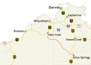
The Tanami Road, also known as the Tanami Track, Tanami Highway, and the McGuire Track, is a road in Australia that runs between the Stuart Highway in the Northern Territory and the Great Northern Highway in Western Australia. It is also known as State Route 5 in the Northern Territory. Its southern junction is 19 kilometres (12 mi) north of Alice Springs and the northern junction is 17 kilometres (11 mi) south-west of Halls Creek. It follows a cattle droving route northwest from the MacDonnell Ranges area of central Australia to Halls Creek in the Kimberley.

The Kennedy Highway is a highway in northern Queensland, Australia. It runs as National Route 1 for approximately 243 km from Smithfield, on the northern outskirts of Cairns, to the Gulf Developmental Road in the vicinity of Forty Mile Scrub and Undara Volcanic national parks. South of this junction, the road continues as the Kennedy Developmental Road to Boulia about 936 kilometres away, via Hughenden. West of the junction, National Route 1 continues as the Gulf Developmental Road to Normanton.

The Great Central Road is a mostly unsealed Australian outback highway that runs 1,126 km (700 mi) from Laverton, Western Australia to Yulara, Northern Territory. It passes through a number of small communities on the way.
The Plenty Highway is a 498-kilometre (309 mi) outback mostly unsealed road in the Northern Territory of Australia between the Stuart Highway and north-western Queensland.

Strzelecki Track is a mostly unsealed outback track in South Australia, linking Innamincka to Lyndhurst.

The Buntine Highway is a 581-kilometre highway in the Northern Territory and Western Australia. It runs from the Victoria Highway via Top Springs and Kalkarindji and then to Nicholson, Western Australia. The section from the Victoria Highway to Kalkaringi is a single-lane sealed road with a few dual-lane sections; the remaining section is unsealed. Funding for maintenance is provided by the Northern Territory government.

Balgo, previously Balgo Hills and Balgo Mission, is a community in Western Australia that is linked with both the Great Sandy Desert and the Tanami Desert. The community is in the Shire of Halls Creek, off the Tanami Road, and was established by German missionaries in 1939. In the 2021 census Balgo's population numbered 430.

The Burke Developmental Road is a Queensland (Australia) developmental road. It links Cloncurry and Normanton in a south–north direction, then turns to the north-east 30 km (19 mi) north of Normanton for 230 km (140 mi) before turning south-east till Dimbulah, where it becomes the Mareeba Dimbulah Road.

The Donohue Highway is a 249 km (155 mi) mostly unpaved outback track that leads through the northern foothills of the Simpson Desert in Queensland to Tobermorey Homestead, Northern Territory near the Northern Territory/Queensland border in Australia.