The Birdsville Track is a notable outback road in Australia. The 517 kilometres (321 mi) track runs between Birdsville in south-western Queensland and Marree, a small town in the north-eastern part of South Australia. It traverses three deserts along the route, the Strzelecki Desert, Sturt Stony Desert and Tirari Desert.

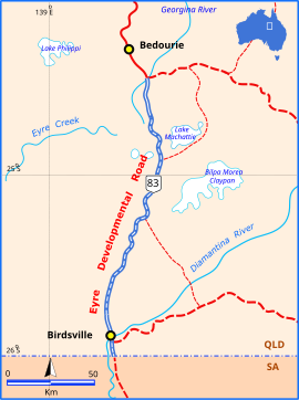
Bedourie is a town and a locality in the Shire of Diamantina, Queensland, Australia. In the 2016 census, Bedourie had a population of 122 people.
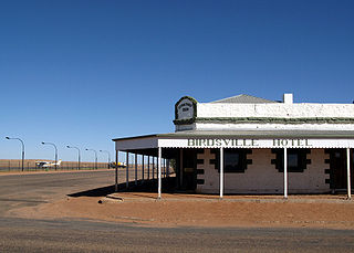
Birdsville is a small town and locality in the Shire of Diamantina, Queensland, Australia.

The Diamantina River is a major river located in Central West Queensland and the far north of South Australia.

The Channel Country is a region of outback Australia mostly in the state of Queensland but also in parts of South Australia, Northern Territory and New South Wales. The name comes from the numerous intertwined rivulets that cross the region, which cover 150,000 km². The Channel Country is over the Cooper and Eromanga geological basins and the Lake Eyre Basin drainage basin. Further to the east is the less arid Maranoa district.

The Kennedy Highway is a highway in northern Queensland, Australia. It runs as National Route 1 for approximately 243 km from Smithfield, on the northern outskirts of Cairns, to the Gulf Developmental Road in the vicinity of Forty Mile Scrub and Undara Volcanic national parks. South of this junction, the road continues as the Kennedy Developmental Road to Boulia about 936 kilometres away, via Hughenden. West of the junction, National Route 1 continues as the Gulf Developmental Road to Normanton.

The Gulf Developmental Road links the Cairns and Normanton regions in northern Queensland, Australia. It is the only sealed (asphalt) road linking these two regions.

The Shire of Diamantina is a local government area in Central West Queensland, bordering South Australia and the Northern Territory. Its administrative centre is in the town of Bedourie.

Birdsville Airport is an airport serving Birdsville, Queensland, Australia. During the Birdsville Races weekend each September, as many as 200 light aircraft visit the airport, with aviators permitted to camp under the wings of their planes. The Channel Mail Run, the world's longest mail run operates between Port Augusta, South Australia and Birdsville, stopping in the town to collect mail for the remote Queensland cattle stations of Glengyle and Durrie.

The Donohue Highway is a 249 km (155 mi) mostly unpaved outback track that leads through the northern foothills of the Simpson Desert in Queensland to Tobermorey Homestead, Northern Territory near the Northern Territory/Queensland border in Australia.

Central West Queensland is a remote region in the Australian state of Queensland which covers 396 650.2 km2. The region lies to the north of South West Queensland and south of the Gulf Country.

Cowarie Station most commonly known as Cowarie is a pastoral lease that operates as a cattle station in north east South Australia.
Pandie Pandie Station, most commonly known as Pandie Pandie, also often spelled as Pandi Pandi or Pandy Pandy, is a pastoral lease that operates as a cattle station in north east South Australia. It lies on the eastern edge of Karanguru territory.

The Diamantina Developmental Road is a gazetted road in Queensland, Australia. that runs from Charleville in the south-central part of the state to Mount Isa in the north-west.

The Wills Developmental Road is a road in north-west Queensland running between Julia Creek and Burketown. As of 2016 it is sealed with a total length of 500 kilometres (310 mi). There are no major towns along the entire route, but fuel and supplies are available at the Burke and Wills Roadhouse and Gregory, Queensland. The Wills Developmental Road joins the Burke Developmental Road for approximately 1.2 kilometres to avoid a direct crossroads at their intersection. Two major rivers are crossed by the Wills Developmental Road en route, the Cloncurry and the Leichhardt.

The Suttor Developmental Road is a highway in the east of the Australian state of Queensland. It runs in SE-NW direction and has a length of 167 km. It connects the Peak Downs Highway with the Bowen Developmental Road. It is signed as State Route 11.

The Fitzroy Developmental Road is a designated road in the Central Highlands Region of Queensland consisting of three separate segments. The general direction is from south to north.

The Thomson Developmental Road is a designated sealed road in south-west Queensland running between Longreach and Windorah. The length is 319 kilometres (198 mi), and it was formerly part of National Route 79 from Melbourne to Longreach. Towns en route are Stonehenge and Jundah, and the road crosses the Thomson River just west of Jundah. The road has no major intersections.
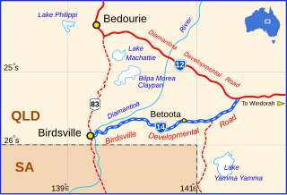
The Birdsville Developmental Road is a mostly unsealed road in south-west Queensland that branches off the Diamantina Developmental Road at a point 103 kilometres (64 mi) west of Windorah and runs to Birdsville. Its length is 273 kilometres (170 mi). The road crosses a major channel of the Diamantina River just prior to reaching Birdsville.

Farrars Creek is a rural locality in the Shire of Barcoo, Queensland, Australia. In the 2016 census, Farrars Creek had a population of 0 people.