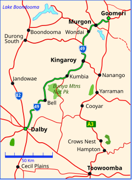
Kingaroy is a rural town and locality in the South Burnett Region, Queensland, Australia. The town is situated on the junction of the D'Aguilar and the Bunya Highways, 218 kilometres (135 mi) north-west of the state capital Brisbane and 141 kilometres (88 mi) south west of Gympie. In the 2021 census, the locality of Kingaroy had a population of 10,266 people.

The Burnett Highway is an inland rural highway located in Queensland, Australia. The highway runs from its junction with the Bruce Highway at Gracemere, just south of Rockhampton, to the D'Aguilar Highway in Nanango. Its length is approximately 542 kilometres. The highway takes its name from the Burnett River, which it crosses in Gayndah. The Burnett Highway provides the most direct link between the northern end of the New England Highway and Rockhampton. It is designated as a State Strategic Road by the Queensland Government.

The D'Aguilar Highway is a two-lane highway linking the Bruce Highway near Caboolture with the Bunya Highway in Kingaroy in the state of Queensland, Australia. Major towns along the route include Woodford, Kilcoy, Blackbutt, Yarraman, and Nanango. The highway is approximately 164 km (102 mi) in length. The D'Aguilar Highway's highest elevation along its length is 527 m just north of Yarraman, and the lowest point is at 26.8 m just west of Caboolture.

Murgon is a rural town and locality in the South Burnett Region, Queensland, Australia. In the 2016 census, the locality of Murgon had a population of 2,378 people.

The Wide Bay Highway is a short state highway of Queensland, Australia running between Goomeri on the Burnett Highway and a junction on the Bruce Highway. From the junction it is 12 kilometres south to Gympie or 69 kilometres north to Maryborough. The length of the highway is 62.6 kilometres. It is a state-controlled regional road.

Goomeri is a rural town and locality in the Gympie Region, Queensland, Australia. In the 2016 census, the locality of Goomeri had a population of 664 people.
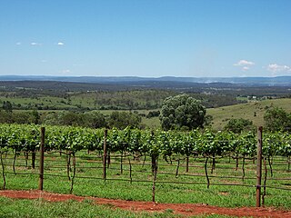
The South Burnett is a peanut growing and wine-producing area on the Great Dividing Range, north of the Darling Downs, in Queensland. It is with the basin of the Burnett River. The area is within two local government areas, South Burnett Region and Gympie Region.

Tingoora is a rural town and a locality in the South Burnett Region, Queensland, Australia.

The Nanango railway line was a narrow-gauge branch railway located in Queensland, Australia. On 31 October 1882, parliament approved the construction of a branch line from Theebine west to Kilkivan after gold and copper were discovered in this region of Queensland, Australia. The section was opened in two stages – to Dickabram on 1 January 1886 after two crossings of the Mary River and to Kilkivan on 6 December 1886.
The Kilkivan to Kingaroy Rail Trail is an 88-kilometre (55 mi) recreation trail from Kilkivan to Kingaroy. The trail follows the old Kingaroy Branch railway and is open to walkers, cyclists and horse riders.
Kilcoy-Murgon Road is a major inland rural road located in Queensland, Australia. It is a state-controlled district road rated as a local road of regional significance (LRRS).

The Suttor Developmental Road is a state-controlled regional road part of which is rated as a local road of regional significance (LRRS). It is a highway in the east of the Australian state of Queensland. It runs in SE-NW direction and has a length of 162 km. It connects the Peak Downs Highway with the Bowen Developmental Road. It is signed as State Route 11.
The Surat Developmental Road is a sealed road in the Western Downs Region, Queensland, Australia. It is a state-controlled district road, rated as a local road of regional significance (LRRS).

Kinbombi is a rural town and locality in the Gympie Region, Queensland, Australia. In the 2016 census, the locality of Kinbombi had a population of 37 people.
Chinchilla–Wondai Road is a continuous 151.6 kilometres (94.2 mi) road route in the Western Downs and South Burnett regions of Queensland, Australia. Part of the route is signed as State Route 82. It is a state-controlled part regional and part district road. It provides an alternate route between the Warrego Highway and the South Burnett, bypassing Dalby, Oakey and Toowoomba.
Toowoomba–Cecil Plains Road is a continuous 78.6 kilometres (48.8 mi) road route in the Toowoomba region of Queensland, Australia. Most of the road is not signed with any route number, but a short section near Cecil Plains is part of State Route 82. Toowoomba–Cecil Plains Road is a state-controlled district road, part of which is rated as a local road of regional significance (LRRS).
Dalby–Jandowae Road is a continuous 47.3 kilometres (29.4 mi) road route in the Western Downs region of Queensland, Australia. The road is signed as State Route 82. Dalby–Jandowae Road is a state-controlled regional road.
The roads that join the towns of Dalby, Oakey and Cooyar form a triangle that encloses some of the most fertile land on the Darling Downs in Queensland, Australia. These roads are the Warrego Highway, Oakey–Cooyar Road and Dalby–Cooyar Road. Several of the more significant internal roads intersect with Dalby–Cooyar Road, and these are briefly described in this article, along with some significant external roads.
Bunya Mountains road network is a group of roads that provide access to the mountain community from various lowland localities. The network ensures continuity of access in times of flooding or other natural disasters, and during planned maintenance activities. The locality of Bunya Mountains includes the Bunya Mountains National Park and the enclosed locality of Mowbullan. The area hosts a small residential community plus many tourism accommodation venues.
Mundubbera–Durong Road is a continuous 105-kilometre (65 mi) road route in the North Burnett and South Burnett local government areas of Queensland, Australia. It is signed as State Route 75. It is a state-controlled regional road. It has been designated as a road of strategic importance by the Federal Government.