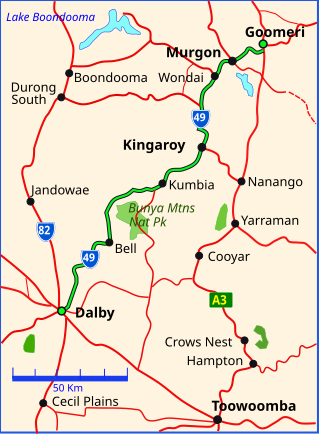
The Bunya Highway is a state highway of Queensland, Australia. It is a relatively short road, running approximately 173 kilometres in a south-westerly direction from Goomeri to Dalby. The highway connects the Warrego and Burnett Highways.

Wondai is a rural town and locality in the South Burnett Region, Queensland, Australia. In the 2021 census, the locality of Wondai had a population of 1,975 people.
Proston is a rural town and locality in the South Burnett Region, Queensland, Australia.

The South Burnett Region is a local government area in the South Burnett district of Queensland, Australia.

Tingoora is a rural town and a locality in the South Burnett Region, Queensland, Australia.

Durong is a rural locality in the South Burnett Region, Queensland, Australia. In the 2021 census, Durong had a population of 219 people.
Okeden is a rural locality in the South Burnett Region, Queensland, Australia. In the 2021 census, Okeden had a population of 53 people.
Chelmsford is a rural locality in the South Burnett Region, Queensland, Australia. In the 2021 census, Chelmsford had a population of 100 people.

Cinnabar is a rural locality in the Gympie Region, Queensland, Australia. In the 2021 census, Cinnabar had a population of 83 people.
Cushnie is a rural locality in the South Burnett Region, Queensland, Australia. In the 2021 census, Cushnie had a population of 145 people.
Wattle Camp is a rural locality in the South Burnett Region, Queensland, Australia. In the 2021 census, Wattle Camp had a population of 543 people.
Keysland is a rural locality in the South Burnett Region, Queensland, Australia. In the 2021 census, Keysland had a population of 19 people.

Kinbombi is a rural town and locality in the Gympie Region, Queensland, Australia. In the 2021 census, the locality of Kinbombi had a population of 34 people.
Leafdale is a rural locality in the South Burnett Region, Queensland, Australia. In the 2021 census, Leafdale had a population of 12 people.

Mondure is a rural town and locality in the South Burnett Region, Queensland, Australia. In the 2021 census, the locality of Mondure had a population of 102 people.

Stonelands is a rural locality in the South Burnett Region, Queensland, Australia. In the 2021 census, Stonelands had a population of 34 people.
Ballogie is a locality in the South Burnett Region, Queensland, Australia. In the 2021 census, Ballogie had a population of 276 people.
Charlestown is a rural locality in the South Burnett Region, Queensland, Australia. In the 2021 census, Charlestown had a population of 79 people.

Coverty is a rural locality in the South Burnett Region, Queensland, Australia. In the 2021 census, Coverty had a population of 107 people.
Kawl Kawl is a rural locality in the South Burnett Region, Queensland, Australia. In the 2021 census, Kawl Kawl had a population of 24 people.
