Charlestown, Queensland

Last updated

Charlestown
Queensland
Australia Queensland location map.svg
Red pog.svg
Charlestown
Coordinates 26°22′00″S151°55′00″E / 26.3666°S 151.9166°E / -26.3666; 151.9166 (Charlestown (centre of locality))
Population79 (SAL 2021) [1]
Postcode(s) 4608
Area190.3 km2 (73.5 sq mi)
Time zone AEST (UTC+10:00)
Location
LGA(s) South Burnett Region
State electorate(s) Nanango
Federal division(s)
Suburbs around Charlestown:
Wondai Cherbourg Moffatdale
Tingoora Charlestown Barambah
Johnstown
Wooroolin Corndale Wyalla
Wattle Camp

Charlestown is a locality in the South Burnett Region, Queensland, Australia. [2] In the 2021 census, Charlestown had a population of 79 people. [3]

Contents

Geography

Most of Charlestown is within protected areas including Wondai State Forest, McEuen State Forest, Cherbourg National Park, and Cherbourg Conservation Park. [4]

Apart from the proteted areas, the predominant land use is grazing on native vegetation with some crop growing. [4]

History

Charlestown Provisional School opened circa 1894 and closed circa 1894. [5]

Demographics

In the 2016 census, Charlestown had a population of 65 people. [6]

In the 2021 census, Charlestown had a population of 79 people. [3]

Education

There are no schools in Charlestown. The nearest government primary schools are Wondai State School in neighbouring Wondai to the north-west, Tingoora State School in neighbouring Tingoora to the west, Wooroolin State School in neighbouring Wooroolin to the south-west, and Moffatdale State School in neighbouring Moffatdale to the north-west. The nearest government secondary schools are Wondai State School (to Year 10) in Wondai, Murgon State High School in Murgon to the north, and Kingaroy State High School in Kingaroy to the south. [4]

Related Research Articles

<span class="mw-page-title-main">Bunya Highway</span> Highway in Queensland

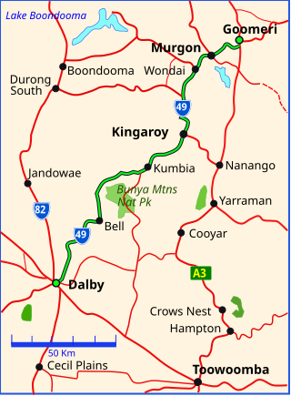
The Bunya Highway is a state highway of Queensland, Australia. It is a relatively short road, running approximately 173 kilometres in a south-westerly direction from Goomeri to Dalby. The highway connects the Warrego and Burnett Highways.

<span class="mw-page-title-main">Murgon</span> Town in Queensland, Australia

Murgon is a rural town and locality in the South Burnett Region, Queensland, Australia. In the 2016 census, the locality of Murgon had a population of 2,378 people.

<span class="mw-page-title-main">Wondai</span> Town in Queensland, Australia

Wondai is a rural town and locality in the South Burnett Region, Queensland, Australia. In the 2021 census, Wondai had a population of 1,975 people.

<span class="mw-page-title-main">Shire of Murgon</span> Local government area in Queensland, Australia

The Shire of Murgon was a local government area in the South Burnett region of Queensland, Australia. The shire covered an area of 664.7 square kilometres (256.6 sq mi), and existed as a local government entity from 1914 until 2008, when it amalgamated with several other councils in the South Burnett area to become the South Burnett Regional Council.

<span class="mw-page-title-main">South Burnett</span> Region in Queensland, Australia

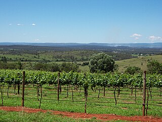
The South Burnett is a peanut growing and wine-producing area on the Great Dividing Range, north of the Darling Downs, in Queensland. It is with the basin of the Burnett River. The area is within two local government areas, South Burnett Region and Gympie Region.

<span class="mw-page-title-main">Tingoora</span> Town in Queensland, Australia

Tingoora is a rural town and a locality in the South Burnett Region, Queensland, Australia.

<span class="mw-page-title-main">Wooroolin, Queensland</span> Town in Queensland, Australia

Wooroolin is a rural town and a locality in the South Burnett Region, Queensland, Australia.

<span class="mw-page-title-main">Memerambi, Queensland</span> Town in Queensland, Australia

Memerambi is a rural town and locality in the South Burnett Region, Queensland, Australia. In the 2021 census, the locality of Memerambi had a population of 338 people.

The Kilkivan to Kingaroy Rail Trail is an 88-kilometre (55 mi) recreation trail from Kilkivan to Kingaroy. The trail follows the old Kingaroy Branch railway and is open to walkers, cyclists and horse riders.

<span class="mw-page-title-main">Durong, Queensland</span> Suburb of South Burnett Region, Queensland, Australia

Durong is a rural locality in the South Burnett Region, Queensland, Australia.

Gordonbrook is a rural locality in the South Burnett Region, Queensland, Australia. In the 2016 census Gordonbrook had a population of 175 people.

<span class="mw-page-title-main">Crawford, Queensland</span> Suburb of South Burnett Region, Queensland, Australia

Crawford is a locality in the South Burnett Region, Queensland, Australia.

<span class="mw-page-title-main">Brooklands, Queensland</span> Suburb of South Burnett Region, Queensland, Australia

Brooklands is a rural locality in the South Burnett Region, Queensland, Australia. In the 2021 census, Brooklands had a population of 324 people.

<span class="mw-page-title-main">Cinnabar, Queensland</span> Suburb of Gympie Region, Queensland, Australia

Cinnabar is a rural locality in the Gympie Region, Queensland, Australia. In the 2016 census, Cinnabar had a population of 72 people.

<span class="mw-page-title-main">Corndale, Queensland</span> Suburb of South Burnett Region, Queensland, Australia

Corndale is a rural locality in the South Burnett Region, Queensland, Australia. In the 2021 census, Corndale had a population of 58 people.

Cushnie is a rural locality in the South Burnett Region, Queensland, Australia.

Keysland is a rural locality in the South Burnett Region, Queensland, Australia. In the 2016 census, Keysland had a population of 12 people.

<span class="mw-page-title-main">Kinbombi</span> Town in Queensland, Australia

Kinbombi is a rural town and locality in the Gympie Region, Queensland, Australia. In the 2016 census, the locality of Kinbombi had a population of 37 people.

Leafdale is a rural locality in the South Burnett Region, Queensland, Australia. In the 2016 census, Leafdale had a population of 28 people.

Moondooner is a rural locality in the South Burnett Region, Queensland, Australia. In the 2016 census, Moondooner had a population of 58 people.

References

  1. Australian Bureau of Statistics (28 June 2022). "Charlestown (Qld) (Suburb and Locality)". Australian Census 2021 QuickStats. Retrieved 28 June 2022.  OOjs UI icon edit-ltr-progressive.svg
  2. "Charlestown – locality in South Burnett Region (entry 46204)". Queensland Place Names. Queensland Government . Retrieved 30 May 2019.
  3. 1 2 Australian Bureau of Statistics (28 June 2022). "Charlestown (SAL)". 2021 Census QuickStats. Retrieved 28 February 2023. OOjs UI icon edit-ltr-progressive.svg
  4. 1 2 3 "Queensland Globe". State of Queensland . Retrieved 30 August 2023.
  5. Queensland Family History Society (2010), Queensland schools past and present (Version 1.01 ed.), Queensland Family History Society, ISBN   978-1-921171-26-0
  6. Australian Bureau of Statistics (27 June 2017). "Charlestown (SSC)". 2016 Census QuickStats. Retrieved 20 October 2018. OOjs UI icon edit-ltr-progressive.svg