
Nanango is a rural town and locality in the South Burnett Region, Queensland, Australia. In the 2021 census, the locality of Nanango had a population of 3,679 people.
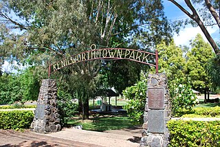
Kenilworth is a rural town and locality in the Sunshine Coast Region, Queensland, Australia. In the 2016 census, the locality of Kenilworth had a population of 558 people. In the 2021 census, Kenilworth had a population of 604 people. The residents of Kenilworth are 49.0% males and 51.0% females and reported a median age of 51 years old.

Tingoora is a rural town and a locality in the South Burnett Region, Queensland, Australia.

Memerambi is a rural town and locality in the South Burnett Region, Queensland, Australia. In the 2021 census, the locality of Memerambi had a population of 338 people.

Benarkin is a rural town and locality in the South Burnett Region, Queensland, Australia. The nearby town of Blackbutt is the origin of the town and the two towns are often referred to as the joint entity Blackbutt-Benarkin. In the 2016 census, Benarkin had a population of 61 people.

Colinton is a rural locality in the Somerset Region, Queensland, Australia. In the 2021 census, Colinton had a population of 60 people.

Didcot is a rural locality in the North Burnett Region, Queensland, Australia. In the 2021 census, Didcot had a population of 85 people.
Pimpimbudgee is a rural locality in the South Burnett Region, Queensland, Australia. In the 2021 census, Pimpimbudgee had a population of 61 people.

Abbeywood is a rural locality in the South Burnett Region, Queensland, Australia. In the 2021 census, Abbeywood had a population of 38 people.

Boonara is a rural locality in the Gympie Region, Queensland, Australia. In the 2021 census, Boonara had a population of 60 people.

Brooklands is a rural locality in the South Burnett Region, Queensland, Australia. In the 2021 census, Brooklands had a population of 324 people.
Goodger is a rural locality in the South Burnett Region, Queensland, Australia. In the 2021 census, Goodger had a population of 176 people.
Manyung is a rural locality split between the Gympie Region and the South Burnett Region, Queensland, Australia. In the 2021 census, Manyung had a population of 83 people.

Mondure is a rural town and locality in the South Burnett Region, Queensland, Australia. In the 2016 census, Mondure had a population of 100 people.
Nukku is a rural locality in the South Burnett Region, Queensland, Australia. In the 2021 census, Nukku had a population of 40 people.
South Nanango is a rural locality in the South Burnett Region, Queensland, Australia. In the 2021 census, South Nanango had a population of 893 people.

East Nanango is a rural locality in the South Burnett Region, Queensland, Australia. In the 2021 census, East Nanango had a population of 273 people.
Glan Devon is a rural locality in the South Burnett Region, Queensland, Australia. In the 2021 census, Glan Devon had a population of 219 people.
South East Nanango is a rural locality in the South Burnett Region, Queensland, Australia. In the 2021 census, South East Nanango had a population of 344 people.
Mount McEuen is a mountain which also gives its name to the surrounding rural locality in the South Burnett Region, Queensland, Australia. In the 2021 census, Mount McEuen had a population of 34 people.
